Category:Dorfkirche Trampe (Barnim)
Jump to navigation
Jump to search
| Object location | | View all coordinates using: OpenStreetMap |
|---|
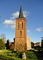
church building in Barnim district, Brandenburg state, Germany _2015_NW.jpg) | |||||
| Upload media | |||||
| Instance of | |||||
|---|---|---|---|---|---|
| Location | Trampe (Barnim), Breydin, Barnim District, Brandenburg, Germany | ||||
| Heritage designation | |||||
 | |||||
This is the category of the Brandenburger Baudenkmal (cultural heritage monument) with the ID 09175302 (Wikidata)
|
English: Trampe church, Breydin municipality, Barnim district, Brandenburg state, Germany
Deutsch: Dorfkirche Trampe, Gemeinde Breydin, Landkreis Barnim, Land Brandenburg, Deutschland
Media in category "Dorfkirche Trampe (Barnim)"
The following 6 files are in this category, out of 6 total.
-
 Dorfkirche Trampe (Barnim) 2015 E.jpg 2,592 × 1,944; 2.19 MB
-
 Dorfkirche Trampe (Barnim) 2015 NE.jpg 2,592 × 1,944; 1.99 MB
-
 Dorfkirche Trampe (Barnim) 2015 NW.jpg 1,944 × 2,592; 1.99 MB
-
 Dorfkirche Trampe (Barnim) 2015 SE.jpg 2,592 × 1,944; 2.16 MB
-
 Dorfkirche Trampe (Barnim) 2015 SW.jpg 1,944 × 2,592; 2.11 MB
-
 Dorfkirche Trampe (Barnim) 2015 W.jpg 1,732 × 2,442; 1.7 MB
_2015_E.jpg)
_2015_NE.jpg)
_2015_SE.jpg)
_2015_SW.jpg)
_2015_W.jpg)