Category:Dorfkirche Warsow (Havelland)
Jump to navigation
Jump to search
| Object location | | View all coordinates using: OpenStreetMap |
|---|
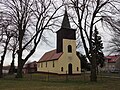
Deutsch: Dorfkirche in Warsow, Gemeinde Wiesenaue, Landkreis Havelland, Land Brandenburg, Deutschland.
Français : Église de Warsow, commune de Wiesenaue, arrondissement Pays de la Havel, état fédéral de Brandebourg, Allemagne
 | |||||
| Upload media | |||||
| Instance of | |||||
|---|---|---|---|---|---|
| Location | Warsow, Wiesenaue, Havelland District, Brandenburg, Germany | ||||
 | |||||
Media in category "Dorfkirche Warsow (Havelland)"
The following 7 files are in this category, out of 7 total.
-
 Dorfkirche Warsow 01.JPG 4,896 × 3,672; 6.31 MB
-
 Dorfkirche Warsow 02.JPG 4,896 × 3,672; 6.28 MB
-
 Dorfkirche Warsow 03.JPG 4,896 × 3,672; 6.19 MB
-
 Dorfkirche Warsow 04.JPG 4,896 × 3,672; 7.61 MB
-
 Dorfkirche Warsow 05.JPG 4,896 × 3,672; 6.78 MB
-
 Dorfkirche Warsow 06.JPG 4,896 × 3,672; 6.88 MB
-
 WarsowKirche.jpg 1,024 × 683; 201 KB


