Category:Dorfkirche Wolsier
Jump to navigation
Jump to search
| Object location | | View all coordinates using: OpenStreetMap |
|---|
 | |||||
| Upload media | |||||
| Instance of | |||||
|---|---|---|---|---|---|
| Location | Wolsier, Havelaue, Havelland District, Brandenburg, Germany | ||||
| Heritage designation | |||||
 | |||||
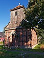
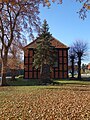
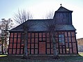
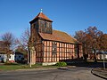
This is the category of the Brandenburger Baudenkmal (cultural heritage monument) with the ID 09150389 (Wikidata)
|
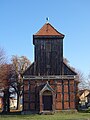
Deutsch: Dorfkirche in Wolsier, Gemeinde Havelaue, Landkreis Havelland, Land Brandenburg, Deutschland.
Français : Église de Wolsier, commune de Havelaue, arrondissement Pays de la Havel, état fédéral de Brandebourg, Allemagne
Media in category "Dorfkirche Wolsier"
The following 17 files are in this category, out of 17 total.
-
 Dorfkirche Wolsier 20211009 1 01.jpg 3,648 × 2,251; 2.81 MB
-
 Dorfkirche Wolsier 20211009 1 02.jpg 3,840 × 5,120; 6.74 MB
-
 Dorfkirche Wolsier 20211009 1 03.jpg 3,648 × 2,736; 4.4 MB
-
 Dorfkirche Wolsier 20211009 1 04.jpg 3,648 × 2,736; 3.69 MB
-
 Dorfkirche Wolsier 20211009 1 05.jpg 3,648 × 2,736; 3.67 MB
-
 Dorfkirche Wolsier 20211009 1 06.jpg 3,648 × 2,736; 3.95 MB
-
 Dorfkirche Wolsier 20211009 1 07.jpg 3,648 × 2,736; 3.8 MB
-
 Wolsier church 2016 blocked portal N.jpg 3,648 × 4,864; 7.14 MB
-
 Wolsier church 2016 E.jpg 3,648 × 4,864; 8.83 MB
-
 Wolsier church 2016 N.jpg 4,864 × 3,648; 7.09 MB
-
 Wolsier church 2016 NE.jpg 4,862 × 3,646; 6.84 MB
-
 Wolsier church 2016 NW.jpg 4,864 × 3,648; 5.55 MB
-
 Wolsier church 2016 portal W.jpg 3,648 × 4,864; 6.58 MB
-
 Wolsier church 2016 S.jpg 4,951 × 4,281; 9.02 MB
-
 Wolsier church 2016 SE.jpg 4,864 × 3,648; 7.64 MB
-
 Wolsier church 2016 SW.jpg 4,864 × 3,648; 6.34 MB
-
 Wolsier church 2016 W.jpg 3,648 × 4,864; 5.34 MB


