Category:Dorfkirche Zabelsdorf
Jump to navigation
Jump to search
| Object location | | View all coordinates using: OpenStreetMap |
|---|
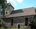
church building in Brandenburg state, Germany  _Feldsteinkirche_Orgel.jpg) | |||||
| Upload media | |||||
| Instance of | |||||
|---|---|---|---|---|---|
| Location | Zabelsdorf, Zehdenick, Oberhavel District, Brandenburg, Germany | ||||
| Heritage designation | |||||
 | |||||
This is the category of the Brandenburger Baudenkmal (cultural heritage monument) with the ID 09165212 (Wikidata)
|
English: Pictures of the church in Zabelsdorf, Zehdenick municipality, Oberhavel district, Brandenburg state, Germany.
Deutsch: Ansichten der Kirche in Zabelsdorf, Stadt Zehdenick, Landkreis Oberhavel, Land Brandenburg, Deutschland.
Français : Photos de l'église à Zabelsdorf, ville de Zehdenick, arrondissement de Oberhavel, état fédéral de Brandebourg, Allemagne
Español: Vistas de la iglesia en Zabelsdorf, ciudad de Zehdenick, distrito de Oberhavel, estado federado de Brandeburgo, Alemania
Address:
Zabelsdorfer Dorfstraße 44, 16792 Zehdenick
Subcategories
This category has only the following subcategory.
I
Pages in category "Dorfkirche Zabelsdorf"
This category contains only the following page.
Media in category "Dorfkirche Zabelsdorf"
The following 7 files are in this category, out of 7 total.
-
 20030710600DR Zabelsdorf (Zehdenick) Feldsteinkirche.jpg 2,705 × 2,235; 3.06 MB
-
 20030710620DR Zabelsdorf (Zehdenick) Feldsteinkirche.jpg 2,533 × 1,863; 3.14 MB
-
 Dorfkirche Zabelsdorf 2020 S.jpg 4,683 × 4,456; 8.29 MB
-
 Dorfkirche Zabelsdorf 2020 Südportal.jpg 4,864 × 3,648; 6.91 MB
-
 Dorfkirche Zabelsdorf 2020 Turm.jpg 3,648 × 4,864; 5.36 MB
-
 Zabelsdorf Kirche 01.JPG 2,600 × 2,112; 2.6 MB
-
 Zabelsdorf Kirchturm.JPG 1,583 × 2,508; 1.97 MB
_Feldsteinkirche.jpg)
_Feldsteinkirche.jpg)


