Category:Dorfkirche Steinbeck (Höhenland)
Jump to navigation
Jump to search
| Object location | | View all coordinates using: OpenStreetMap |
|---|
This is the category of the Brandenburger Baudenkmal (cultural heritage monument) with the ID 09180690 (Wikidata)
|
church building in Brandenburg state, Germany _2018_N.jpg) _2018_Innen_E.jpg) | |||||
| Upload media | |||||
| Instance of | |||||
|---|---|---|---|---|---|
| Location | Steinbeck (Höhenland), Höhenland, Märkisch-Oderland District, Brandenburg, Germany | ||||
| Heritage designation | |||||
 | |||||
English: Pictures of the church in Steinbeck , Höhenland municipality , Märkisch-Oderland district, Brandenburg state, Germany.
Deutsch: Ansichten der Kirche in Steinbeck , Gemeinde Höhenland , Landkreis Märkisch-Oderland , Land Brandenburg, Deutschland.
Français : Photos de l'église à Steinbeck , commune de Höhenland , arrondissement de Märkisch-Oderland , état fédéral de Brandebourg, Allemagne
Español: Vistas de la iglesia en Steinbeck , municipio de Höhenland , distrito de Märkisch-Oderland , estado federado de Brandeburgo, Alemania
Address:
Steinbecker Dorfstraße 27, Steinbeck, 16259 Höhenland
Subcategories
This category has only the following subcategory.
Pages in category "Dorfkirche Steinbeck (Höhenland)"
This category contains only the following page.
Media in category "Dorfkirche Steinbeck (Höhenland)"
The following 5 files are in this category, out of 5 total.
-
 Dorfkirche Steinbeck (Höhenland) 2018 N.jpg 4,864 × 3,648; 6.98 MB
-
 Dorfkirche Steinbeck (Höhenland) 2018 NNE.jpg 4,792 × 3,552; 6.77 MB
-
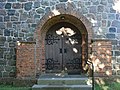 Dorfkirche Steinbeck (Höhenland) 2018 Westportal.jpg 4,864 × 3,648; 5.82 MB
-
 IMG 8478SteinbeckDorfkirche.jpg 600 × 400; 87 KB
-
 Steinbecks Dorfkirche - panoramio.jpg 1,600 × 1,200; 841 KB
_2018_NNE.jpg)
_2018_Westportal.jpg)

