Category:Drainage divides
Aller à la navigation
Aller à la recherche
Deutsch: Wasserscheide.
English: The term 'WATERSHED' is used differently in North American English, and those parts of the of the world more influenced by British academics.
- Drainage divides—(contrast to w:Drainage basin)— include mountain ranges, districts, and individual mountain peaks, located on a w:water divide, the place where two raindrops falling near the same point, flow downhill to different streams.
Français : Lignes de partage des eaux.
Italiano: Linee di spartiacque.
Divides which are in Mountain passes (technically 'Cols' in English) are most correctly categorized into Category:Mountain saddles (the vernacular for Cols).
ligne de séparation de bassins versants  | |||||
| Téléverser des médias | |||||
| Sous-classe de | |||||
|---|---|---|---|---|---|
| |||||
Sous-catégories
Cette catégorie comprend 6 sous-catégories, dont les 6 ci-dessous.
C
G
M
T
Média dans la catégorie « Drainage divides »
Cette catégorie comprend 59 fichiers, dont les 59 ci-dessous.
-
 Basin-Border Water-Shed Vistula-Prypjat(Dnepr).png 481 × 378 ; 100 kio
-
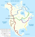
 Europäische Wasserscheiden Ostsee.png 459 × 419 ; 129 kio
-
 Hydrographische Karte 1852 Rathlef.jpg 1 603 × 2 112 ; 1 000 kio
-
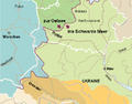
 Memel-Becken Europäische Wasserscheide Ostsee-Scharzes Meer.jpg 251 × 176 ; 12 kio
-
 Weichsel-Becken Europäische Wasserscheide Ostsee-Scharzes Meer.jpg 450 × 567 ; 81 kio
-
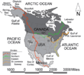
 NorthAmerica-WaterDivides.png 900 × 900 ; 370 kio
-
 NorthAmerica-WaterDivides.svg 1 677 × 1 789 ; 1,03 Mio
-
 NorthAmericaDivides.gif 540 × 481 ; 56 kio
-
 SouthAmerica-ContinentalDivide.png 648 × 838 ; 795 kio
-

-
 1773-Flexenpass-N.jpg 6 016 × 3 384 ; 6,88 Mio
-
 Europäische Wasserscheiden - Zoom auf Pass Lunghin.png 1 200 × 1 184 ; 700 kio
-
 Main chain of the Alps.jpg 404 × 198 ; 21 kio
-
 Alps orographic.png 600 × 371 ; 262 kio
-
 At Blakehope Nick - geograph.org.uk - 113025.jpg 1 280 × 960 ; 927 kio
-
 Atlantik-Nordsee-Wasserscheide.png 2 118 × 1 516 ; 673 kio
-
 Bealach Traligill - geograph.org.uk - 158717.jpg 640 × 447 ; 99 kio
-
 Bega.jpg 900 × 174 ; 73 kio
-
 Bolshaya Ipelka.jpg 640 × 468 ; 48 kio
-
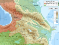 Caucasus hydro map-fr.svg 1 155 × 898 ; 5,42 Mio
-
 Continental Divide, Ontario Highway 11, Between Fort Frances and Thunder Bay, Ontario (43925756282).jpg 3 860 × 2 656 ; 12,57 Mio
-
 Cuenca del Boeza - Divisoria de aguas.png 800 × 565 ; 202 kio
-
 East West Watershed - geograph.org.uk - 169098.jpg 640 × 474 ; 82 kio
-
En-us-watershed.ogg 1,0 s ; 19 kio
-
 Euroopa veelahkmed.png 1 200 × 1 184 ; 620 kio
-
 Weichsel Pregel Memel Windau Düna.png 332 × 190 ; 45 kio
-
 Europäische Wasserscheide - panoramio (1).jpg 4 608 × 3 456 ; 6,05 Mio
-
 Figure of a drainage basin.svg 512 × 275 ; 643 kio
-
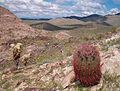 Granite Wash Mountains 2005.jpg 1 632 × 1 232 ; 756 kio
-
 Great Basin National Park 102007 031.JPG 2 304 × 1 452 ; 482 kio
-
 GreenValleySignEdit2717.jpg 588 × 686 ; 273 kio
-
 Hwy 101 Divide ON.jpg 1 298 × 981 ; 245 kio
-
 Hydrographia Germaniæ.png 4 964 × 4 132 ; 31,33 Mio
-
 Zollmann Hydrographia Germaniae.jpg 4 577 × 3 885 ; 17,37 Mio
-
 Iberian-drainage-divide.png 683 × 496 ; 580 kio
-
 Ríos de Andalucía with water divide.png 989 × 607 ; 155 kio
-
 Iran drainage basins.png 610 × 608 ; 402 kio
-
 Israel Drainage divide.jpg 249 × 598 ; 15 kio
-
 Kirche-poppberg.jpg 1 200 × 1 600 ; 173 kio
-
 La Biche divide sign.jpg 2 048 × 1 108 ; 699 kio
-
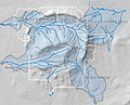 Bassins versants du Mont-Mégantic.jpg 3 144 × 2 551 ; 2,95 Mio
-

-
 Sangyeongpyo (1913).pdf 750 × 1 185, 112 pages ; 22,24 Mio
-
 Schuylkill-Lehigh River Drainage Divides USGS, Hazelton-Mauch Chunk & Mountain Quads, NW+NE-4.jpg 2 890 × 2 730 ; 2,01 Mio
-
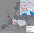
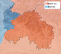 Sea Basins South Ossetia.svg 6 082 × 5 404 ; 549 kio
-
 Triple Lochans - geograph.org.uk - 231553.jpg 640 × 440 ; 92 kio
-
 Triple-pass-divide-thumb.jpg 750 × 500 ; 151 kio
-
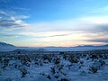 Utah winter scene in Great Basin.jpg 2 304 × 1 728 ; 681 kio
-
 Waldkarpaten Bieszczady 1.jpg 600 × 450 ; 97 kio
-
 Wasserscheide.svg 709 × 448 ; 122 kio
-
 Watershed-Gudenå-Skjernå.jpg 1 360 × 908 ; 915 kio
-
 WatershedDivide-Grand-UpperThames.jpg 2 592 × 1 944 ; 1,22 Mio
-
 Wododil-1.jpg 3 072 × 2 304 ; 4,23 Mio
-
 Wododil-3.jpg 3 072 × 2 304 ; 3,44 Mio
-
 Z85wasserscheide.jpg 1 000 × 750 ; 132 kio
-
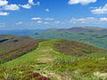
 Aonach Breac - geograph.org.uk - 1406515.jpg 640 × 480 ; 140 kio
-
 Burn of Tarland watershed - geograph.org.uk - 1513626.jpg 640 × 373 ; 89 kio
-
 Corran River watershed - geograph.org.uk - 1424765.jpg 640 × 480 ; 90 kio
-
 Pass of Drumochter - Watershed - geograph.org.uk - 353449.jpg 640 × 472 ; 112 kio
.png)


%27_(11159562855).jpg)


.jpg)


.jpg)


_(14566027347).jpg)


