Category:Drought in Australia
Jump to navigation
Jump to search
Countries of Oceania: Australia
rainfall deficiency in Australia | |||||
| Upload media | |||||
| Subclass of | |||||
|---|---|---|---|---|---|
| Location |
| ||||
| |||||
Media in category "Drought in Australia"
The following 51 files are in this category, out of 51 total.
-
 15 April 2009 Duststorm in Wagga Wagga.jpg 1,600 × 1,064; 1.38 MB
-
 1944 drought.jpg 1,550 × 2,493; 936 KB
-
 Callistemon desiccated by drought.jpg 4,000 × 3,000; 2.13 MB
-
 Cows on a sand island in the Murrumbidgee River.jpg 1,500 × 997; 931 KB
-
 CSIRO ScienceImage 429 Drought Effected Landscape.jpg 2,559 × 1,636; 4.25 MB
-
 CSIRO ScienceImage 505 Drought Affected Ground.jpg 1,697 × 2,563; 4.25 MB
-
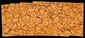
 CSIRO ScienceImage 607 Effects of Drought on the Soil.jpg 2,552 × 1,672; 4.8 MB
-
 Dead and dying Cyprinus carpio carpio in Lake Albert.jpg 2,000 × 1,313; 2.51 MB
-
 Drought affected paddock on the Hay Plains.jpg 1,911 × 2,996; 1.98 MB
-
 Drought affected River Red Gums along Redbank Road.jpg 2,000 × 1,330; 2.19 MB
-
 Drought and heatwave affected London Plane Trees (Platanus × hispanica).jpg 1,600 × 1,064; 2.1 MB
-
 Drought in the wetlands of the Coorong National Park.jpg 1,632 × 1,232; 1.24 MB
-
 Drought Swimming Hole.JPG 3,872 × 2,592; 4.86 MB
-
 Drought, Hughenden, Queensland, Australia 2014-08-09 11-19.jpg 2,057 × 1,536; 1.04 MB
-
 Drought, Hughenden, Queensland, Australia 2014-08-09 11-20.jpg 2,057 × 1,536; 1.15 MB
-
 Drought-affected paddock in North Wagga.jpg 1,500 × 997; 535 KB
-
 Dry sowing near Junee to east.jpg 1,832 × 1,152; 1.51 MB
-
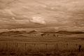 DrySeasonFarming-Tasmania-Australia-Sepia.jpg 4,896 × 3,264; 4.06 MB
-
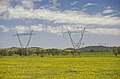 Electricity pylons and paddocks of Capeweed.jpg 2,000 × 1,317; 2.02 MB
-
 Endless Stations 102 - Beautifully Dry.jpg 5,120 × 2,320; 14.16 MB
-
 Feeding cattle cotton seeds.jpg 687 × 515; 93 KB
-
 Fields outside benambra.jpg 2,250 × 924; 587 KB
-
 Harsh existance in the drought.... - panoramio.jpg 2,244 × 1,496; 1.13 MB
-
 Jimmy the Rain Gauge.jpg 2,175 × 3,471; 1.6 MB
-
 Lac Hume.jpg 2,048 × 1,536; 1.04 MB
-
 Lake Albert 30 January 2010 panorama.jpg 4,300 × 499; 2.6 MB
-
 Lake Albert covered in a unknown water weed.jpg 997 × 1,500; 650 KB
-
 Lake Albert panorama 30 January 2010.jpg 2,000 × 733; 1.59 MB
-
 Lake Albert Panorama.jpg 2,500 × 950; 909 KB
-
 Lake Albert viewed from Rocky Hill 01.jpg 2,000 × 1,330; 2.52 MB
-
 Lake Albert viewed from Rocky Hill.jpg 2,000 × 1,330; 2.05 MB
-
 Lake Hume on the Upper Murray.jpg 1,840 × 1,224; 2.35 MB
-
 OnTheRoadFromHayToBooligal.jpg 600 × 878; 68 KB
-

-
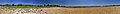
 Panorama from the northern end on the lake bed of Lake Albert polar.jpg 1,014 × 1,014; 687 KB
-
 Panorama from the northern end on the lake bed of Lake Albert.jpg 8,500 × 1,016; 7.37 MB
-
 Panorama of the southeastern end of Lake Albert.jpg 5,500 × 700; 4.35 MB
-
 Panorama of the southern end of Lake Albert.jpg 5,600 × 998; 7.07 MB
-
 Panorama of the southwestern end of Lake Albert.jpg 8,200 × 801; 6.77 MB
-
 Progardes surving drought Richmond Qld Feb 2014 4555.JPG 3,648 × 2,736; 5.1 MB
-

-

-

-
-
 Riverina Sheep (during drought).jpg 2,816 × 2,112; 1.81 MB
-
 Sheep on a drought-affected paddock.jpg 1,600 × 1,064; 1.88 MB
-
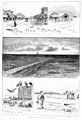
 The drought, sheep at a dry creek 1878.jpg 1,000 × 688; 270 KB
-
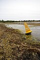
 Water depth marker in the dry lake bed of Lake Albert.jpg 1,330 × 2,000; 2.34 MB
-
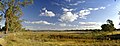
 Wetland during drought Girraween National Park Wyberba Queensland 1980s IMG 0012 (3).jpg 6,416 × 4,304; 19.57 MB
-
 Wetland in drought Girraween National Park Wyberba Queensland 1990s IMG 0009 (3).jpg 6,400 × 4,304; 19.13 MB
-
 Wollundry Lagoon dried up during the 1912 drought.jpg 1,000 × 700; 487 KB


.jpg)


.jpg)


.jpg)


.jpg)
.jpg)
