Category:Dyatlov Pass incident
Pereiti į navigaciją
Jump to search
unsolved deaths of nine ski hikers in the northern Ural Mountains in the Soviet Union (now Russia) between 1 February and 2 February 1959  A view of the tent as the rescuers found it on Feb. 26, 1959. The tent had been cut open from inside, and most of the skiers had fled in socks or barefoot. Photo taken by soviet authorities at the camp of the Dyatlov Pass incident and anexed to the legal inquest that investigated the deaths.   | |||||
| Įkelti mediją | |||||
| Tai yra | |||||
|---|---|---|---|---|---|
| Pavadintas pagal | |||||
| Vieta |
| ||||
| Taškas laike |
| ||||
| Number of deaths |
| ||||
| Number of injured |
| ||||
| Skiriasi nuo | |||||
 | |||||
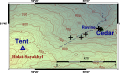
English: The Dyatlov Pass incident refers to an event that resulted in the deaths of nine ski hikers in the northern Ural mountains on the night of February 2, 1959. It happened on the east shoulder of the mountain Kholat Syakhl (Холат Сяхл) (a Mansi name, meaning Mountain of the Dead). The mountain pass where the incident occurred has since been named Dyatlov Pass (Перевал Дятлова) after the group's leader, Igor Dyatlov (Игорь Дятлов).
Daugialypės terpės rinkmenos kategorijoje „Dyatlov Pass incident“
Rodomi 35 šios kategorijos rinkmenos (iš viso kategorijoje yra 35 rinkmenos).
-
 3d model of dyatlov pass 1.png 1 920 × 1 080; 2,13 MiB
-
 Cycle map of djatlov pass incident 1.svg 931 × 688; 1 MiB
-
 Djatlov pass incident map 1.png 1 280 × 720; 66 KiB
-
 Djatlov pass incident map 1.svg 1 200 × 675; 80 KiB
-
 Draft map of Dyatlov pass 3.png 960 × 720; 48 KiB
-
 Draft map of Dyatlov pass 3.svg 992 × 558; 92 KiB
-
 Dyatlov Pass incident 02.jpg 809 × 640; 394 KiB
-
 Dyatlov pass incident accurate fancy map 1.svg 956 × 559; 332 KiB
-
 Dyatlov pass incident accurate fancy map 2.svg 708 × 430; 541 KiB
-
 Dyatlov pass incident accurate fancy map 3.svg 708 × 410; 88 KiB
-
 Dyatlov pass incident accurate fancy map 4.svg 634 × 378; 49 KiB
-
 Dyatlov pass incident accurate mountain and tent map 1.svg 730 × 380; 268 KiB
-
 Dyatlov pass incident accurate mountain and tent map 2.svg 730 × 776; 189 KiB
-
 Dyatlov pass incident avalanche possibility map 1.svg 730 × 503; 488 KiB
-
 Dyatlov pass incident avalanche possibility map 2.svg 730 × 430; 501 KiB
-
 Dyatlov pass incident fancy map 1.svg 744 × 686; 1,17 MiB
-
 Dyatlov pass incident fancy map 2.svg 1 000 × 483; 681 KiB
-
 Dyatlov pass incident fancy map 3.svg 1 071 × 980; 8,48 MiB
-
 Dyatlov pass incident satellite height map 1.svg 1 029 × 508; 1 008 KiB
-
 Dyatlov pass incident slope map 1.svg 730 × 503; 4,33 MiB
-
 Dyatlov.Volume 1.Original cover.jpg 431 × 651; 232 KiB
-
 Dyatlov.Volume 1.Page 1 verso.jpg 2 199 × 3 728; 706 KiB
-
 Dyatlov.Volume 1.Page 1.jpg 2 280 × 3 731; 897 KiB
-
 Dyatlov.Volume 1.Page 301 verso.jpg 2 328 × 3 672; 849 KiB
-
 Dyatlov.Volume 1.Page 301.jpg 2 327 × 3 667; 826 KiB
-
 Dyatlov.Volume 1.Page 340.jpg 2 393 × 3 714; 910 KiB
-
 Dyatlov.Volume 1.Page 370.jpg 2 550 × 3 510; 755 KiB
-
 Dyatlov.Volume 1.Page 384.jpg 2 284 × 3 797; 999 KiB
-
 Dyatlov.Volume 1.Page 385.jpg 2 299 × 3 796; 1,03 MiB
-
 Dyatlov.Volume 1.Page 386.jpg 2 290 × 3 796; 1,11 MiB
-
 Dyatlov.Volume 1.Page 387.jpg 2 325 × 3 796; 994 KiB
-
 Map of djatlov pass incident 2.svg 998 × 560; 138 KiB
-
 Topo map of djatlov pass incident 1.svg 989 × 688; 3,63 MiB
-
 Ауспия 2015.JPG 3 264 × 2 448; 3,96 MiB
-
 Юрий Коптелов. Заметки о поисковых работах (группа Дятлова).jpg 2 400 × 3 000; 926 KiB


.jpg)