Category:Early Cycladic settlement Skarkos in Ios
Jump to navigation
Jump to search
| Object location | | View all coordinates using: OpenStreetMap |
|---|
archaeological site  Jaciment de Skarkos | |||||
| Upload media | |||||
| Instance of | |||||
|---|---|---|---|---|---|
| Culture | |||||
| Location | Ios Municipality, Thira Regional Unit, South Aegean Region, Decentralized Administration of the Aegean, Greece | ||||
| Heritage designation |
| ||||
 | |||||
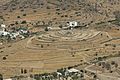
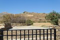
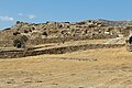
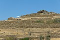
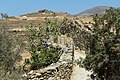
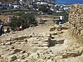
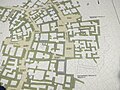
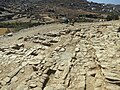
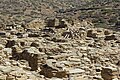
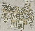
Early Cycladic settlement on the hill Skarkos on the island of Ios. One of the largest excavated settlements of this civilization. Early Bronze Age, EC II, 2800 to 2300 BC.
There were, however, already something older. Also later there was a Mycenaean cemetery (Late Bronze Age, LC).
Pages in category "Early Cycladic settlement Skarkos in Ios"
This category contains only the following page.
Media in category "Early Cycladic settlement Skarkos in Ios"
The following 39 files are in this category, out of 39 total.
-
 13M814.jpg 2,812 × 1,880; 3.66 MB
-
 Early Cycladic settlement Skarkos from kastro, Ios, 130344.jpg 4,992 × 3,328; 8.48 MB
-
 Skarkos 130258.jpg 5,184 × 3,456; 11.58 MB
-
 Skarkos 130260.jpg 5,184 × 3,456; 8.2 MB
-
 Skarkos 130265.jpg 5,184 × 3,456; 8.74 MB
-
 Skarkos 130294.jpg 5,184 × 3,456; 7.87 MB
-
 Skarkos 130295.jpg 5,184 × 3,456; 8.16 MB
-
 Skarkos 130296.jpg 5,184 × 3,456; 7.57 MB
-
 Skarkos 130298.jpg 5,184 × 3,456; 7.85 MB
-
 Skarkos 130302.jpg 5,184 × 3,456; 8.78 MB
-
 Skarkos 130303.jpg 5,184 × 3,456; 9.09 MB
-
 Skarkos 130306.jpg 5,184 × 3,456; 8.19 MB
-
 Skarkos 130307.jpg 5,184 × 3,456; 7.95 MB
-
 Skarkos 130309.jpg 5,184 × 3,456; 7.87 MB
-
 Skarkos 130320.jpg 5,184 × 3,456; 8.31 MB
-
 Skarkos 13M796.jpg 2,710 × 1,788; 2.7 MB
-
 Skarkos 13M805.jpg 2,816 × 2,112; 3.62 MB
-
 Skarkos 13M807.jpg 2,816 × 2,112; 3.76 MB
-
 Skarkos 13M808.jpg 2,816 × 1,882; 3.88 MB
-
 Skarkos 13M817.jpg 2,815 × 1,874; 3.25 MB
-
 Skarkos 13M824.jpg 2,752 × 2,030; 3.02 MB
-
 Skarkos EC II 113M816.jpg 2,816 × 2,112; 3.65 MB
-
 Skarkos EC II 130262.jpg 5,184 × 3,456; 9.08 MB
-
 Skarkos EC II 130263.jpg 5,184 × 3,456; 9.38 MB
-
 Skarkos EC II 130264.jpg 4,906 × 3,255; 9.52 MB
-
 Skarkos EC II 130268.jpg 5,184 × 3,456; 10.11 MB
-
 Skarkos EC II 130269.jpg 5,184 × 3,456; 8.81 MB
-
 Skarkos EC II 130270.jpg 5,184 × 3,456; 9.21 MB
-
 Skarkos EC II 130271.jpg 5,184 × 3,456; 9 MB
-
 Skarkos EC II 130272.jpg 5,184 × 3,456; 9.85 MB
-
 Skarkos EC II 130274.jpg 5,184 × 3,456; 7.95 MB
-
 Skarkos EC II 130275.jpg 5,184 × 3,456; 8.27 MB
-
 Skarkos EC II 130285.jpg 5,184 × 3,456; 7.65 MB
-
 Skarkos EC II 130286.jpg 5,184 × 3,456; 8.66 MB
-
 Skarkos EC II 130287.jpg 5,184 × 3,456; 9.21 MB
-
 Skarkos EC II 130288.jpg 5,184 × 3,456; 9.11 MB
-
 Skarkos Hill Settlement on Ios.jpg 1,024 × 768; 1.15 MB
-
 Skarkos map 130266.jpg 3,866 × 3,411; 6.75 MB
-
 Σκάρκος 6253.jpg 4,608 × 3,072; 6.98 MB


