Category:Earthquakes
Przejdź do nawigacji
Przejdź do wyszukiwania
| Category Earthquakes on sister projects: | |||||||||
|---|---|---|---|---|---|---|---|---|---|
Wikinews |
Commons | ||||||||
| Earthquakes by year |
Català: Terratrèmols.
- Afegeix la teva nova imatge a la [[Category:Earthquakes of (any)]], exemple: Category: Earthquakes by year
Deutsch: Erdbebenereignis.
- Neue Bilder können in der entsprechenden Unterkategorie im Schema [[Category:Earthquakes of (year)]] hinzugefügt werden. Die entsprechenden Jahreskategorien sind unter Category: Earthquakes by year zu finden.
English: Earthquakes.
- Add your new image into a [[Category:Earthquakes of (year)]] subcategory, found under Category: Earthquakes by year.
Español: Terremotos.
rozładowanie naprężeń litosfery  | |||||
| Prześlij plik multimedialny | |||||
| Podklasa dla |
| ||||
|---|---|---|---|---|---|
| Inne niż | |||||
| |||||
Podkategorie
Poniżej wyświetlono 29 spośród wszystkich 29 podkategorii tej kategorii.
*
+
- Books about earthquakes (3 pliki)
- Earthquake icons (8 plików)
- Map of volcanoes and earthquakes (2 pliki)
A
D
E
- Earthquake-triggered avalanches (2 pliki)
G
L
- Locked faults (4 pliki)
P
- Population exposure to earthquakes (4 pliki)
S
- Earthquake scarps (6 plików)
- Seismograms (185 plików)
T
Ō
†
Pliki w kategorii „Earthquakes”
Poniżej wyświetlono 77 spośród wszystkich 77 plików w tej kategorii.
-
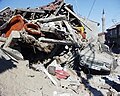
 09.21 總統出席「大規模震災消防救災動員演練」.jpg 2048 × 1365; 1,75 MB
-
 1995paphosearthquake.png 940 × 565; 272 KB
-
 1995paphosquake.png 529 × 531; 131 KB
-
 2021 Taiwan Fault Distribution Map.jpg 1240 × 1754; 503 KB
-
 Amplification Model of Ground Acceleration in a Site.jpg 3024 × 4032; 2,7 MB
-
 Artificial earthquakes.jpg 2048 × 1536; 204 KB
-
 Ashfdiuqg.jpg 5312 × 2988; 5,95 MB
-
 Distribution-map-of-large-rock-avalanches-triggered-by-the-Wenchuan-earthquake.png 1223 × 1038; 2,02 MB
-
 Earthquake (HY).svg 512 × 436; 13 KB
-
 Earthquake .jpg 437 × 503; 71 KB
-
Earthquake Below.ogv 14 min 24 s, 400 × 300; 63,19 MB
-
 Earthquake casualties.jpg 441 × 526; 115 KB
-
 Earthquake safety (HY).svg 512 × 272; 108 KB
-
 Earthquake Safety Checklist (zh-cn) text.pdf 1275 × 1650, 8 stron; 258 KB
-
 Earthquake Safety Checklist (zh-cn).pdf 750 × 1650, 14 stron; 2,1 MB
-
 Earthquake safty.svg 512 × 273; 101 KB
-
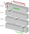
 Earthquake wave shadow zone japanese2.svg 450 × 550; 229 KB
-
Earthquake.ogg 2 min 40 s; 971 KB
-
Earthquakes of the First 15 Years of the 21st Cent.ogv 3 min 50 s, 1280 × 720; 114,75 MB
-
Earthquakes of the First 15 Years of the 21st Century.webm 3 min 50 s, 3840 × 2160; 713,81 MB
-
 Emergency light.JPG 1280 × 960; 228 KB
-
 Emergency Storehouse.jpg 1280 × 960; 241 KB
-
 Epizentroa eta hipozentroa.jpg 337 × 221; 37 KB
-
 Exemple intensityM7.jpg 977 × 600; 241 KB
-
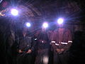
 Failures in mine.jpg 1024 × 768; 255 KB
-
 FALHA DE SAMAMBAIA.png 1064 × 637; 1,78 MB
-
 Fault&Earthquake generation IT.png 1280 × 720; 146 KB
-
 Fig.1.1-1.4 59, 83, 84, 167, 170, 250 year cycles in 40 major earthquakes (M8.4).pdf 1239 × 1754, 4 strony; 180 KB
-
 Fig.2.1-2.16.pdf 1239 × 1754, 21 stron; 5,2 MB
-
-
-
 Fig.8-Map of Moon position at the time of 39 large earthquakes (M8.4).pdf 1239 × 1754; 203 KB
-
 Fig.9-Map of The direction of the earth-moon system.pdf 1239 × 1754; 364 KB
-
Fr-tremblement-terre.ogg 1,8 s; 20 KB
-
 Gambar Cincin Api Pasifik.png 3568 × 2619; 16,04 MB
-
 Gangwonearthquake.jpg 3444 × 2130; 2,01 MB
-
 Graph of the number of earthquakes.svg 512 × 512; 125 KB
-
 Grieta en barranco por temblor de Mala.jpg 1250 × 735; 271 KB
-
 Ground failure.jpeg 761 × 512; 53 KB
-
 Historischer Seismograph.jpg 5077 × 3316; 7,99 MB
-
 IBM Mainframe Server Mounted on THK Seismic Isolation Table TSD.jpg 445 × 567; 272 KB
-
 Informal refugee's camp in Ponce.jpg 4608 × 3456; 7,15 MB
-
 Interferogram Iran.jpg 948 × 485; 282 KB
-
 ITK.manimaran.jpg 1280 × 959; 101 KB
-
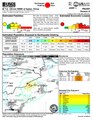
 JMA Tsunami Warnings 1 January 2024 ja.png 878 × 988; 257 KB
-
 Kandilli-Erdbebenwarte-Wagen.jpg 5184 × 3456; 7,25 MB
-
Kurzerklärt - Richtiges Verhalten bei Erdbeben.webm 45 s, 1080 × 1920; 51,53 MB
-
Kurzerklärt - So entstehen Erdbeben.webm 25 s, 720 × 1280; 25,88 MB
-
 Lurrikararen eskema.png 666 × 546; 740 KB
-
 Map of the Kermadec and Tonga subduction trench.jpg 3292 × 3690; 1,8 MB
-
 Miner in mine.jpg 1536 × 2048; 107 KB
-
 Phase unwrapping.jpg 1287 × 458; 83 KB
-
 Proteccion.jpg 1536 × 2048; 1,17 MB
-
-
 Richter magnitude scale (HY).svg 512 × 274; 96 KB
-
 Sawtooth Range, Idaho earthquakes (25 July 2020 to 24 August 2020).jpg 1113 × 688; 160 KB
-
 Screenshot of my emails with Okal.png 1502 × 660; 64 KB
-
 Shadow zone graph diagram japanese.svg 800 × 500; 27 KB
-
So entsteht ein Erdbeben.webm 1 min 44 s, 1920 × 1080; 124,15 MB
-
 Summary of Tables explaining the JMA Seismic Intensity Scale.pdf 1239 × 1752; 803 KB
-
 Surface Ruptures.png 625 × 116; 104 KB
-
 Terremoto de Almería de 1522.jpg 323 × 492; 61 KB
-
 The Pager of 2024 Uqturpan earthquake.pdf 1275 × 1650; 677 KB
-
 The Philosophy of Earthquakes, Natural and Religious.djvu 1275 × 1650, 98 stron; 3,77 MB
-
 The-Puente-Hills-Fault-L.A.s-Biggest-Monster.jpg 1200 × 630; 119 KB
-
 The-Puente-Hills-Fault-Map-LA.jpg 945 × 630; 523 KB
-
 Tsunami formation .png 639 × 479; 441 KB
-
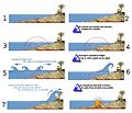 Tsunami-étapes.jpg 1284 × 1104; 532 KB
-
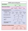 UCERF3 LogicTreeTD v15.png 1103 × 1226; 182 KB
-
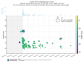 Us7000lsze aftershocks dp magnitude vs day.png 1200 × 900; 112 KB
-
Vampire 3component.ogg 30 s; 299 KB
-
 Yıkılan Bir Ev 1.jpg 251 × 201; 13 KB
-
 Yıkılan Bir Ev 2.jpg 265 × 190; 10 KB
-
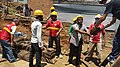
 Young Scientists.jpg 1600 × 1200; 269 KB
-
 Zemetrasenie Komárno.jpg 1870 × 916; 309 KB
-
探访云南漾濞县地震安置点:物资充足 井然有序.webm 1 min 52 s, 1920 × 1080; 42,73 MB
-
 郯城大地震的烈度图.jpg 1429 × 1880; 876 KB


.svg)


.svg)


.svg)
.jpg)


