Category:Ehemaliges Rathaus (Odersbach)
Jump to navigation
Jump to search
| Object location | | View all coordinates using: OpenStreetMap |
|---|
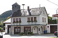
Cultural heritage monument in Odersbach, Hesse, Germany  | |||||
| Upload media | |||||
| Instance of | |||||
|---|---|---|---|---|---|
| Location | Weilburg-Odersbach, Weilburg, Limburg-Weilburg, Giessen Government Region, Hesse, Germany | ||||
| Street address |
| ||||
| Heritage designation | |||||
 | |||||
This is the category of the Hessian Kulturdenkmal (cultural monument) with the ID 52521 (Wikidata)
|
Media in category "Ehemaliges Rathaus (Odersbach)"
The following 6 files are in this category, out of 6 total.
-
 Weilburg-Odersbach WLMMH 52521 by Stepro IMG 1244.JPG 3,168 × 4,752; 5.45 MB
-
 Weilburg-Odersbach WLMMH 52521 by Stepro IMG 1246.JPG 4,752 × 3,168; 5.2 MB
-
 Weilburg-Odersbach WLMMH 52521 by Stepro IMG 1247.JPG 4,752 × 3,168; 4.49 MB
-
 Weilburg-Odersbach WLMMH 52521 by Stepro IMG 1248.JPG 4,752 × 3,168; 4.41 MB
-
 Weilburg-Odersbach WLMMH 52521 by Stepro IMG 1249.JPG 3,168 × 4,752; 4.58 MB
-
 Weilburg-Odersbach WLMMH 52521 by Stepro IMG 1250.JPG 4,752 × 3,168; 5.22 MB


