Category:Erinnerungsmal an den Luftangriff (Stettfeld)
Jump to navigation
Jump to search
This is the category of the Bavarian Baudenkmal (cultural heritage monument) with the ID D-6-74-201-2 (Wikidata)
|
| Object location | | View all coordinates using: OpenStreetMap |
|---|
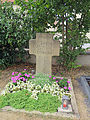
Deutsch: Erinnerungsmal an den Luftangriff 1944, um 1955. Nähe Kirchplatz/Gartenstraße, im Kirchhof, Stettfeld, Landkreis Haßberge, Unterfranken, Deutschland
Media in category "Erinnerungsmal an den Luftangriff (Stettfeld)"
This category contains only the following file.
-
 D-6-74-201-2 Erinnerungsmal an den Luftangriff.jpg 3,000 × 4,000; 2.49 MB
