Category:Evangelische Kirche (Jabel in der Prignitz)
Jump to navigation
Jump to search
| Object location | | View all coordinates using: OpenStreetMap |
|---|
 | |||||
| Upload media | |||||
| Instance of | |||||
|---|---|---|---|---|---|
| Location | Jabel, Heiligengrabe, Ostprignitz-Ruppin District, Brandenburg, Germany | ||||
| Heritage designation | |||||
 | |||||
This is the category of the Brandenburger Baudenkmal (cultural heritage monument) with the ID 09170819 (Wikidata)
|
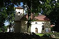
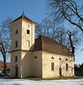
Deutsch: Die Evangelische Kirche in Jabel in der Prignitz (zu Heiligengrabe), Mark Brandenburg, gehört und dient einer lutherischen Gemeinde der unierten Evangelischen Kirche Berlin-Brandenburg-Schlesische Oberlausitz.
English: The Protestant Church in Jabel in the Prignitz (a locality of Heiligengrabe), March of Brandenburg, Germany, is owned and used by a Lutheran congregation within the Evangelical Church of Berlin-Brandenburg-Silesian Upper Lusatia, a united Protestant church body of Calvinist, Lutheran and united congregations.
Media in category "Evangelische Kirche (Jabel in der Prignitz)"
The following 3 files are in this category, out of 3 total.
-
 Dorkirche Jabel Heiligengrabe.jpg 4,928 × 3,264; 10.08 MB
-
 Jabel church 2013.jpg 1,992 × 2,040; 619 KB
-
 Jabel church.jpg 1,422 × 1,470; 304 KB

