Category:Fanellhorn
Zur Navigation springen
Zur Suche springen
| Objektposition | | Karte mit allen Koordinaten: OpenStreetMap |
|---|
Berg in den Alpen    | |||||
| Medium hochladen | |||||
| Ist ein(e) | |||||
|---|---|---|---|---|---|
| Ort | Kanton Graubünden, Schweiz | ||||
| Gebirgszug |
| ||||
| Schartenhöhe |
| ||||
| Dominanz |
| ||||
| Höhe über dem Meeresspiegel |
| ||||
| Bezugsberg | |||||
 | |||||
Medien in der Kategorie „Fanellhorn“
Folgende 11 Dateien sind in dieser Kategorie, von 11 insgesamt.
-
 Chilchalphorn and Fanell Glacier.jpg 4.032 × 3.024; 3,33 MB
-
 Fanellhorn as seen from Zervreilahorn.jpg 4.608 × 3.456; 7,18 MB
-
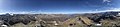 Fanellhorn Panorama.jpg 16.382 × 3.628; 7,69 MB
-
 Fanellhorn Spherical Panorama.jpg 21.504 × 10.752; 38,29 MB
-
 Fanellhorn-aug-2018.jpg 4.896 × 3.672; 6,74 MB
-
 Fanellhorn-ausblick-aug-2018.jpg 4.896 × 3.672; 5,63 MB
-
 Fanellhorn-wegweiser-aug-2018.jpg 4.896 × 3.672; 7,57 MB
-
 Fanellhorn.JPG 2.592 × 1.944; 2,25 MB
-
 Guraletschhorn and Ampervreilhorn.jpg 3.024 × 4.032; 3,42 MB
-
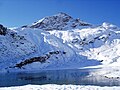
 Guraletschsee.jpg 3.024 × 4.032; 2,74 MB
-
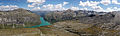 Zerfreilasee.jpg 5.802 × 1.730; 3,79 MB


