Category:Adula Alps
Jump to navigation
Jump to search
part of Swiss Alps containing Mt. Adula or Rheinwaldhorn  | |||||
| Upload media | |||||
| Instance of |
| ||||
|---|---|---|---|---|---|
| Made from material | |||||
| Location | |||||
| Mountain range |
| ||||
| Highest point | |||||
| Elevation above sea level |
| ||||
 | |||||
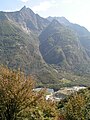
The Lepontine Alps are a mountain range in the north-western part of the Alps. They are located in Switzerland (Valais, Ticino, Uri and Graubünden) and Italy (Piedmont and Lombardy). The eastern portion of the Lepontine Alps, from the St Gotthard Pass to the Splügen Pass, is sometimes named the Adula Alps.
Subcategories
This category has the following 38 subcategories, out of 38 total.
A
- Pizzas d’Anarosa (26 F)
B
- Breitstock (Adula Alps) (2 F)
C
- Capanna Quarnei (6 F)
- Chilchalphorn (8 F)
- Cima Rossa (Adula Alps) (13 F)
- Cogn (9 F)
- Crest Ault (7 F)
- Crest dil Cut (10 F)
- Croce di Sasso (8 F)
E
- Einshorn (14 F)
F
- Fanellhorn (11 F)
- Furggeltihorn (11 F)
G
- Glaser Grat (4 F)
- Grauhorn (Adula) (10 F)
- Güferhorn (20 F)
L
- Lago di Luzzone (40 F)
- Lüschgrat (2 F)
M
- Pizzo Magn (24 F)
- Matro (22 F)
- Piz Muraun (6 F)
P
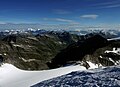
- Panoramics of the Adula Alps (12 F)
- Pianca Bella (10 F)
- Pizzo Pianché (13 F)
- Cima di Pinadee (10 F)
- Piz de Groven (4 F)
- Pizzo di Claro (23 F)
- Präzer Höhi (32 F)
R
S
- Sosto (22 F)
V
Z
- Zapporthorn (7 F)
Pages in category "Adula Alps"
The following 2 pages are in this category, out of 2 total.
Media in category "Adula Alps"
The following 45 files are in this category, out of 45 total.
-
 Aerial photographs 2010 -Adula-Alpen- by-RaBoe 032.jpg 1,111 × 738; 801 KB
-
 Aerial photographs 2010-by-RaBoe-33.jpg 1,111 × 738; 880 KB
-
 Aerial photographs 2010-by-RaBoe-34.jpg 1,111 × 738; 849 KB
-
 Bellinzona from above.jpg 4,032 × 2,268; 4.65 MB
-
 Blick in die Bergwelt von Graubünden.jpg 3,456 × 2,304; 4.78 MB
-
 Bruschghorn von Turrahuus.jpg 963 × 801; 225 KB
-
 Buzza di Biasca 3274.jpg 480 × 640; 116 KB
-
 CapBrogoldoneSO.jpg 1,024 × 768; 143 KB
-
 Chur - 27-47.jpg 3,457 × 4,998; 3.58 MB
-
 Pizzo Cramorino.jpg 2,592 × 1,944; 1.54 MB
-
 ETH-BIB-Casserio bei Corzonesco-LBS H1-015909.tif 6,628 × 4,555; 86.55 MB
-

-
 ETH-BIB-Piz Giuv, Piz Nair, Adula v. N. aus 3300 m-Inlandflüge-LBS MH01-006316.tif 6,409 × 4,334; 79.61 MB
-

-
 ETH-BIB-Rheinwaldtal, Nufenen, Adulagruppe v. O. aus 3200 m-Inlandflüge-LBS MH01-003773.tif 6,482 × 4,429; 82.27 MB
-
-
-
 ETH-BIB-Valle di Blenio, Blick nach Norden, Piz Vial-LBS H1-009206.tif 6,425 × 4,424; 81.43 MB
-
 ETH-BIB-Valle Leventina, Blick Ostsüdosten Piz di Strega-LBS H1-027312.tif 8,392 × 5,940; 142.66 MB
-
 ETH-BIB-Valle Leventina, Blick Südosten Piz di Strega-LBS H1-027313.tif 8,589 × 5,900; 145.02 MB
-
 Garzora-SO.jpg 6,000 × 3,376; 4.67 MB
-
 Gipfel Val Sumvitg Ostseite.jpg 2,198 × 1,338; 1.68 MB
-
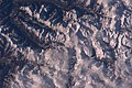 ISS012-E-15613 - View of Switzerland.jpg 1,520 × 1,008; 157 KB
-
 ISS022-E-100576 - View of Switzerland.jpg 4,288 × 2,848; 2.06 MB
-
 ISS022-E-5797 - View of Switzerland.jpg 4,288 × 2,848; 1.6 MB
-
 ISS022-E-5798 - View of Switzerland.jpg 4,288 × 2,848; 1.54 MB
-
 ISS027-E-8014 - View of Switzerland.jpg 4,288 × 2,929; 1.94 MB
-
 ISS030-E-17134 - View of Switzerland.jpg 4,288 × 2,848; 1.99 MB
-
 ISS031-E-30409 - View of Switzerland.jpg 4,256 × 2,832; 1.59 MB
-
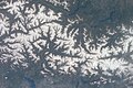
 ISS061-E-13445 - View of Earth.jpg 5,568 × 3,712; 3.09 MB
-
 ISS061-E-13446 - View of Earth.jpg 5,568 × 3,712; 3.08 MB
-
 ISS061-E-13448 - View of Earth.jpg 5,568 × 3,712; 3.35 MB
-
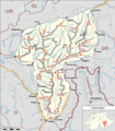 Karte Adula-Alpen.png 3,295 × 3,757; 2.98 MB
-
 Laentatal.jpg 2,722 × 1,980; 1.21 MB
-
 Lago di Luzzone from NE.jpg 5,349 × 3,566; 7.43 MB
-
 Lajets & Pass Cristallina.jpg 4,912 × 3,264; 5.09 MB
-
 Lavaz-Gletscher 2011.jpg 4,912 × 3,264; 7.34 MB
-
 Madra e la Val Madra viste da Anzano - panoramio.jpg 600 × 800; 141 KB
-
 Malvaglia Air3.jpg 4,056 × 3,040; 6.91 MB
-
 PizMedel (cropped).JPG 1,510 × 912; 546 KB
-
 PizMedel.JPG 1,600 × 1,200; 758 KB
-
 Pizzo di Claro.jpg 1,584 × 1,097; 477 KB
-
 Ri di Mutarasc.jpg 1,746 × 2,620; 2.23 MB
-
 Val Soja.jpg 1,200 × 1,600; 1.03 MB
-
 Veduta su Biasca.jpg 640 × 480; 259 KB


.JPG)


