Category:Feldkapelle (Gartenäcker)
Jump to navigation
Jump to search
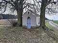
This is the category of the Bavarian Baudenkmal (cultural heritage monument) with the ID D-3-77-139-32 (Wikidata)
|
| Object location | | View all coordinates using: OpenStreetMap |
|---|
building in Mähring, Upper Palatinate, Germany  | |||||
| Upload media | |||||
| Instance of | |||||
|---|---|---|---|---|---|
| Location | Mähring, Tirschenreuth, Upper Palatinate, Bavaria, Germany | ||||
| Street address |
| ||||
| Heritage designation | |||||
 | |||||
Media in category "Feldkapelle (Gartenäcker)"
The following 2 files are in this category, out of 2 total.
-
 Feldkapelle - Gartenäcker, am Weg nach Dippersreuth.jpg 4,000 × 3,000; 6.75 MB
-
 Feldkapelle - Gartenäcker, am Weg nach Dippersreuth2.jpg 4,000 × 3,000; 6.93 MB
