Category:Felslindl (A 54)
Jump to navigation
Jump to search
Geotop in Landkreis Amberg-Sulzbach in Bavaria, Germany  | |||||
| Upload media | |||||
| Instance of | |||||
|---|---|---|---|---|---|
| Location | Auerbach in der Oberpfalz, Amberg-Sulzbach, Upper Palatinate, Bavaria, Germany | ||||
| Heritage designation | |||||
| Width |
| ||||
| Length |
| ||||
| Area |
| ||||
| Elevation above sea level |
| ||||
| official website | |||||
 | |||||
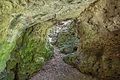
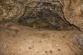
Deutsch: Die Felslindl (HFA-Katasternummer: A 54) ist eine Karsthöhle bei Saaß. Sie ist ein Geotop (371H008) sowie ein Naturdenkmal.
Media in category "Felslindl (A 54)"
The following 9 files are in this category, out of 9 total.
-
 2016 Felslindl 01.jpg 5,184 × 3,456; 5.53 MB
-
 2016 Felslindl 02.jpg 5,184 × 3,456; 5.42 MB
-
 2016 Felslindl 03.jpg 5,184 × 3,456; 5.15 MB
-
 2016 Felslindl 04.jpg 5,184 × 3,456; 6.74 MB
-
 2016 Felslindl 05.jpg 5,184 × 3,456; 5.49 MB
-
 2016 Felslindl 06.jpg 3,456 × 5,184; 4.4 MB
-
 Felsländl 1 - panoramio.jpg 2,048 × 1,536; 562 KB
-
 Felsländl 2 - panoramio.jpg 2,048 × 1,536; 786 KB
-
 Felsländl 3 - panoramio.jpg 2,048 × 1,536; 613 KB


Categories:
- Caves of Karstgebiet A
- Geography in Auerbach in der Oberpfalz
- Caves of Landkreis Amberg-Sulzbach
- Natural monuments in Landkreis Amberg-Sulzbach
- Geotopes in Landkreis Amberg-Sulzbach
- Felsen am Speckbach
- Saaß (Auerbach in der Oberpfalz)
- Caves in Naturpark Fränkische Schweiz-Veldensteiner Forst
- Geotopes in Naturpark Fränkische Schweiz-Veldensteiner Forst
- Protected areas in Naturpark Fränkische Schweiz-Veldensteiner Forst