Category:Fifehead Neville
Jump to navigation
Jump to search
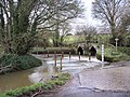
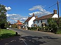
English: Fifehead Neville is a village in north Dorset, England, situated in the Blackmore Vale two miles south west of Sturminster Newton. The village has a population of 127. The village is situated next to the River Divelish which runs down from the high plains of Bulbarrow Hill. Thomas Hardy, who variously lived in nearby Dorchester and Sturminster Newton, once remarked of Fifehead Neville "Never before have I seen such beauty and activity combine so harminously."
village and civil parish in Dorset, United Kingdom  | |||||
| Upload media | |||||
| Instance of | |||||
|---|---|---|---|---|---|
| Location | Dorset, South West England, England | ||||
 | |||||
Subcategories
This category has the following 2 subcategories, out of 2 total.
A
F
Media in category "Fifehead Neville"
The following 57 files are in this category, out of 57 total.
-
 'Ford' south of Fifehead St. Quintin - geograph.org.uk - 5644761.jpg 640 × 480; 186 KB
-
 Bluebells, Fudge Copse - geograph.org.uk - 5351785.jpg 640 × 480; 241 KB
-

-
 Old Chapel, Fifehead Neville - geograph.org.uk - 336417.jpg 640 × 480; 120 KB
-
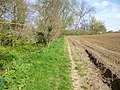
 Countryside near Fifehead Neville - geograph.org.uk - 1530910.jpg 640 × 480; 69 KB
-
 Crate Hill - geograph.org.uk - 5644653.jpg 640 × 480; 120 KB
-
-
 Fifehead Common - geograph.org.uk - 3446967.jpg 1,024 × 768; 275 KB
-
 Fifehead Neville Ford - geograph.org.uk - 4550181.jpg 1,084 × 725; 384 KB
-
 Fifehead Neville Village Hall - geograph.org.uk - 3446196.jpg 1,024 × 768; 169 KB
-
 Fifehead Neville, country lane - geograph.org.uk - 3446272.jpg 1,024 × 768; 262 KB
-
 Fifehead Neville, farm buildings - geograph.org.uk - 3446200.jpg 1,024 × 768; 175 KB
-
 Fifehead Neville, footpath - geograph.org.uk - 3446202.jpg 768 × 1,024; 332 KB
-
 Fifehead Neville, footpath - geograph.org.uk - 3446813.jpg 1,024 × 768; 332 KB
-
 Fifehead Neville, ford - geograph.org.uk - 3446280.jpg 1,024 × 768; 332 KB
-
 Fifehead Neville, ford ^ bridge - geograph.org.uk - 3446207.jpg 1,024 × 768; 342 KB
-

-

-
 Fifehead Neville, stile - geograph.org.uk - 3446822.jpg 1,024 × 768; 332 KB
-
 Fifehead Neville, the telephone box - geograph.org.uk - 3794187.jpg 480 × 640; 105 KB
-
 Fifehead St Quintin Ford - geograph.org.uk - 4550158.jpg 1,084 × 725; 433 KB
-
 Fifehead St Quintin, byway - geograph.org.uk - 3447585.jpg 1,024 × 768; 352 KB
-
 Fifehead St Quintin, farm entrance - geograph.org.uk - 3447611.jpg 1,024 × 768; 199 KB
-
 Fifehead St Quintin, ford and bridge - geograph.org.uk - 3447595.jpg 1,024 × 768; 205 KB
-
 Fifehead St Quintin, gas pipeline marker - geograph.org.uk - 3447619.jpg 768 × 1,024; 188 KB
-
 Fifehead St Quintin, River Divelish - geograph.org.uk - 3447572.jpg 1,024 × 768; 226 KB
-
 Fifehead St Quintin, River Divelish - geograph.org.uk - 3447599.jpg 1,024 × 768; 367 KB
-
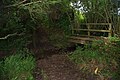
 Footbridge over River Divelish - geograph.org.uk - 5351794.jpg 640 × 480; 218 KB
-

-
 Ford at Fifehead St Quintin - geograph.org.uk - 4550170.jpg 1,084 × 725; 396 KB
-
 Ford near Fifehead Neville - geograph.org.uk - 1530958.jpg 640 × 480; 114 KB
-
 Ford, Fifehead Neville - geograph.org.uk - 336340.jpg 640 × 480; 162 KB
-
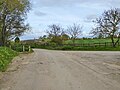
 Gateway view - geograph.org.uk - 5644648.jpg 640 × 480; 118 KB
-
 Kitford Ford - geograph.org.uk - 4550149.jpg 1,084 × 725; 452 KB
-
 Kitford, ford - geograph.org.uk - 3331354.jpg 1,024 × 768; 250 KB
-
 Lane towards Fifehead St Quintin - geograph.org.uk - 5644803.jpg 640 × 480; 189 KB
-
 Laneside Early Purple Orchids - geograph.org.uk - 5644792.jpg 640 × 480; 248 KB
-
 Old pump, Lower Fifehead Farm - geograph.org.uk - 5351801.jpg 640 × 480; 172 KB
-
 Pasture near Fifehead Neville - geograph.org.uk - 1530957.jpg 640 × 422; 54 KB
-
 Road junction, Fifehead Common - geograph.org.uk - 5351815.jpg 640 × 480; 108 KB
-
 Road towards Fifehead Common - geograph.org.uk - 5644644.jpg 640 × 480; 151 KB
-

-
-
 Barn on Haydon Lane near Fifehead Neville - geograph.org.uk - 653631.jpg 640 × 480; 104 KB
-
 Bridleway gate near Salkeld Bridge - geograph.org.uk - 336374.jpg 640 × 480; 133 KB
-

-
 Bridleway, Fifehead Neville - geograph.org.uk - 336368.jpg 640 × 480; 107 KB
-
 Cockcrow Copse from Zoar Lane - geograph.org.uk - 570654.jpg 640 × 426; 124 KB
-
 Coolplay - kids' indoor play park - geograph.org.uk - 336387.jpg 640 × 480; 80 KB
-
 Fifehead St Quinton - geograph.org.uk - 386167.jpg 640 × 480; 185 KB
-

-
 Home Farm, Fifehead Neville - geograph.org.uk - 336413.jpg 640 × 480; 106 KB
-
 Little Haydon Farm - geograph.org.uk - 653617.jpg 640 × 480; 112 KB
-
 Locketts Cottages - geograph.org.uk - 570663.jpg 640 × 426; 82 KB
-

-

-


