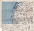
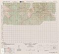
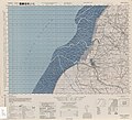
Category:Formosa (Taiwan) 1:50,000 AMS Series L792
Jump to navigation
Jump to search
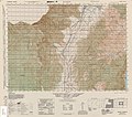
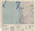
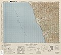
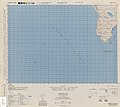
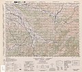
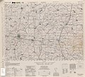
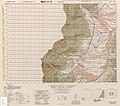
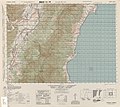
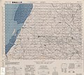
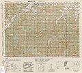
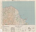
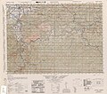
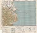
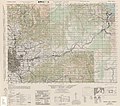
English: Maps of Formosa (Taiwan) produced by the Army Map Service, United States Army Corps of Engineers, 1944-1945 (see also Political divisions of Taiwan (1895–1945)). Courtesy of the University of Texas Libraries, The University of Texas at Austin. Includes at least 105 map sheets plus the index map; in total 106 maps. Location names in the maps are alphabetically indexed in "Gazetteer to Maps of Formosa (Taiwan) Map Series AMS L792, Scale 1:50,000". Listed by sheet number here. Some maps based on the Japanese Imperial Land Survey's 1927 1:50,000 maps of Taiwan: see page 281
Other maps[1] in the series that may have been produced:
2119-I, Tokatsukutsu, Formosa
2214-III, Daijurin-San, Formosa
2214-IV, Minami-Daibu-San, Formosa
2219-IV, Taiwan-Toyohara
Other maps[1] in the series that may have been produced:
2119-I, Tokatsukutsu, Formosa
2214-III, Daijurin-San, Formosa
2214-IV, Minami-Daibu-San, Formosa
2219-IV, Taiwan-Toyohara
-
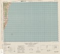
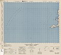
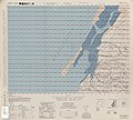
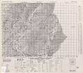
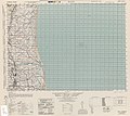
 Index Map

Media in category "Formosa (Taiwan) 1:50,000 AMS Series L792"
The following 107 files are in this category, out of 107 total.
-
 Gazetteer to maps of Formosa (Taiwan).pdf 1,239 × 1,754, 210 pages; 306.45 MB
-
Index map Series L792.jpg 2,200 × 3,214; 967 KB
-
 Txu-pclmaps-oclc-6550512-ari-san-2217-i.jpg 4,648 × 4,175; 8.92 MB
-
 Txu-pclmaps-oclc-6550512-babukutsu-2315-i.jpg 4,680 × 4,155; 3.84 MB
-
 Txu-pclmaps-oclc-6550512-bandai-2318-iv.jpg 4,733 × 4,160; 7.97 MB
-
 Txu-pclmaps-oclc-6550512-basshi-2317-i.jpg 4,682 × 4,126; 8.7 MB
-
 Txu-pclmaps-oclc-6550512-bokushi-2117-iii.jpg 4,657 × 4,185; 5.12 MB
-
 Txu-pclmaps-oclc-6550512-bombon-yama-2320-i.jpg 4,719 × 4,162; 8.56 MB
-
 Txu-pclmaps-oclc-6550512-bozan-2213-iv.jpg 4,677 × 4,227; 5.71 MB
-
 Txu-pclmaps-oclc-6550512-byobi-to-2212-iv.jpg 4,666 × 4,176; 3.54 MB
-
 Txu-pclmaps-oclc-6550512-byoko-2417-iv.jpg 4,630 × 4,166; 3.85 MB
-
 Txu-pclmaps-oclc-6550512-byoritsu-2220-i.jpg 4,619 × 4,134; 7.41 MB
-
 Txu-pclmaps-oclc-6550512-chikuto-2321-iii.jpg 4,705 × 4,139; 9.08 MB
-
 Txu-pclmaps-oclc-6550512-chuho-2217-iii.jpg 4,680 × 4,129; 8.03 MB
-
 Txu-pclmaps-oclc-6550512-chureki-2321-iv.jpg 4,684 × 4,169; 7.48 MB
-
 Txu-pclmaps-oclc-6550512-daibu-2214-ii.jpg 4,659 × 4,146; 7.9 MB
-
 Txu-pclmaps-oclc-6550512-dora-2220-ii.jpg 4,614 × 4,188; 7.79 MB
-
 Txu-pclmaps-oclc-6550512-gaian-1917-i.jpg 4,638 × 4,176; 3.31 MB
-
 Txu-pclmaps-oclc-6550512-garan-bi-2212-i.jpg 4,676 × 4,214; 4.42 MB
-
 Txu-pclmaps-oclc-6550512-gokan-zan-2319-ii.jpg 4,680 × 4,134; 8.18 MB
-
 Txu-pclmaps-oclc-6550512-goshi-zan-2320-iv.jpg 4,739 × 4,169; 7.96 MB
-
 Txu-pclmaps-oclc-6550512-hakushaton-2220-iv.jpg 4,634 × 4,191; 4.21 MB
-
 Txu-pclmaps-oclc-6550512-hana-shima-1917-ii.jpg 4,668 × 4,235; 3.87 MB
-
 Txu-pclmaps-oclc-6550512-hokko-2117-i.jpg 4,598 × 4,185; 5.81 MB
-
 Txu-pclmaps-oclc-6550512-hori-2218-i.jpg 4,664 × 4,158; 9.36 MB
-
 Txu-pclmaps-oclc-6550512-horin-2318-ii.jpg 4,668 × 4,137; 6.53 MB
-
 Txu-pclmaps-oclc-6550512-kagi-2117-ii.jpg 4,655 × 4,195; 6.94 MB
-
 Txu-pclmaps-oclc-6550512-kaiko-2118-iii.jpg 4,675 × 4,195; 4.38 MB
-
 Txu-pclmaps-oclc-6550512-kakubanzazn-2321-ii.jpg 4,664 × 4,169; 7.72 MB
-
 Txu-pclmaps-oclc-6550512-kannon-bana-2213-i.jpg 4,657 × 4,136; 6.78 MB
-
 Txu-pclmaps-oclc-6550512-karenko-2418-iv.jpg 4,687 × 4,171; 5.44 MB
-
 Txu-pclmaps-oclc-6550512-kasho-to-2314-i.jpg 4,645 × 4,189; 3.73 MB
-
 Txu-pclmaps-oclc-6550512-kasowan-2316-i.jpg 4,678 × 4,172; 7.32 MB
-
 Txu-pclmaps-oclc-6550512-keishu-2118-i.jpg 4,603 × 4,161; 5.45 MB
-
 Txu-pclmaps-oclc-6550512-kendouru-san-2215-ii.jpg 4,663 × 4,213; 9.25 MB
-
 Txu-pclmaps-oclc-6550512-kitsubai-to-2018-iii.jpg 4,615 × 4,178; 3.48 MB
-
 Txu-pclmaps-oclc-6550512-kizan-2115-i.jpg 4,673 × 4,204; 7.42 MB
-
 Txu-pclmaps-oclc-6550512-kobi-2118-ii.jpg 4,620 × 4,162; 5.84 MB
-
 Txu-pclmaps-oclc-6550512-koho-2316-iv.jpg 4,685 × 4,149; 7 MB
-
 Txu-pclmaps-oclc-6550512-kokusei-2219-ii.jpg 4,680 × 4,172; 8.59 MB
-
 Txu-pclmaps-oclc-6550512-kosei-to-2017-iii.jpg 4,601 × 4,205; 3.35 MB
-
 Txu-pclmaps-oclc-6550512-kosen-2216-iii.jpg 4,685 × 4,157; 6.65 MB
-
 Txu-pclmaps-oclc-6550512-koshibutsu-2213-ii.jpg 4,614 × 4,132; 6.52 MB
-
 Txu-pclmaps-oclc-6550512-koshun-2213-iii.jpg 4,666 × 4,136; 4.67 MB
-
 Txu-pclmaps-oclc-6550512-koto-sho-2413-iii.jpg 4,670 × 4,176; 4.45 MB
-
 Txu-pclmaps-oclc-6550512-kyuko-2221-i.jpg 4,921 × 4,323; 3.38 MB
-
 Txu-pclmaps-oclc-6550512-mako-2017-iv.jpg 4,693 × 4,185; 4.77 MB
-
 Txu-pclmaps-oclc-6550512-mato-2116-iv.jpg 4,638 × 4,190; 5.62 MB
-
 Txu-pclmaps-oclc-6550512-mida-2115-iii.jpg 4,670 × 4,213; 3.62 MB
-
 Txu-pclmaps-oclc-6550512-mino-2215-iv.jpg 4,657 × 4,143; 8.5 MB
-
 Txu-pclmaps-oclc-6550512-mu-sha-2319-iii.jpg 4,729 × 4,173; 8.25 MB
-
 Txu-pclmaps-oclc-6550512-nanko-tai-san-2320-ii.jpg 4,738 × 4,153; 8.05 MB
-
 Txu-pclmaps-oclc-6550512-nanshi-2115-ii.jpg 4,641 × 4,201; 5.98 MB
-
 Txu-pclmaps-oclc-6550512-niitaka-yama-2217-ii.jpg 4,626 × 4,197; 6.03 MB
-
 Txu-pclmaps-oclc-6550512-noko-zan-2318-i.jpg 4,693 × 4,162; 10.02 MB
-
 Txu-pclmaps-oclc-6550512-nonto-2218-iv.jpg 4,636 × 4,133; 7.52 MB
-
 Txu-pclmaps-oclc-6550512-o-shima-1916-i.jpg 4,636 × 4,214; 3.52 MB
-
 Txu-pclmaps-oclc-6550512-osono-2322-iii.jpg 4,607 × 4,159; 4.85 MB
-
 Txu-pclmaps-oclc-6550512-raipunroku-2215-i.jpg 4,738 × 4,212; 4.79 MB
-
 Txu-pclmaps-oclc-6550512-riran-2316-iii.jpg 4,637 × 4,134; 6.79 MB
-
 Txu-pclmaps-oclc-6550512-rokko-2119-ii.jpg 4,605 × 4,196; 4.91 MB
-
 Txu-pclmaps-oclc-6550512-saigaen-2215-iii.jpg 4,678 × 4,194; 7.73 MB
-
 Txu-pclmaps-oclc-6550512-seira-keiko-2118-iv.jpg 4,689 × 4,195; 3.46 MB
-
 Txu-pclmaps-oclc-6550512-shinchiku-2221-ii.jpg 4,563 × 4,171; 5.68 MB
-
 Txu-pclmaps-oclc-6550512-shinei-2116-i.jpg 4,666 × 4,208; 7.58 MB
-
 Txu-pclmaps-oclc-6550512-shinka-2116-ii.jpg 4,621 × 4,165; 7.37 MB
-
 Txu-pclmaps-oclc-6550512-shinko-2316-ii.jpg 4,648 × 4,168; 6.16 MB
-
 Txu-pclmaps-oclc-6550512-shushu-2218-ii.jpg 4,651 × 4,206; 7.82 MB
-
 Txu-pclmaps-oclc-6550512-suirembi-2418-iii.jpg 4,666 × 4,166; 4.86 MB
-
 Txu-pclmaps-oclc-6550512-suirin-2117-iv.jpg 4,642 × 4,195; 4.89 MB
-
 Txu-pclmaps-oclc-6550512-tabito-2319-i.jpg 4,698 × 4,169; 8.21 MB
-
 Txu-pclmaps-oclc-6550512-taichu-2219-iii.jpg 4,596 × 4,183; 7.02 MB
-
 Txu-pclmaps-oclc-6550512-taiho-2216-iv.jpg 4,724 × 4,216; 6.64 MB
-
 Txu-pclmaps-oclc-6550512-taihoku-west-2322-ii.jpg 4,603 × 4,145; 7.62 MB
-
 Txu-pclmaps-oclc-6550512-taiko-2220-iii.jpg 4,600 × 4,178; 5.74 MB
-
 Txu-pclmaps-oclc-6550512-tainan-north-2116-iii.jpg 4,662 × 4,193; 6.42 MB
-
 Txu-pclmaps-oclc-6550512-tainan-south-2115-iv.jpg 4,676 × 4,182; 4.1 MB
-
 Txu-pclmaps-oclc-6550512-taito-2315-iii.jpg 4,654 × 4,140; 5.25 MB
-
 Txu-pclmaps-oclc-6550512-takao-2114-i.jpg 4,712 × 4,214; 5.61 MB
-
 Txu-pclmaps-oclc-6550512-takezaki-2217-iv.jpg 4,626 × 4,176; 9.16 MB
-
 Txu-pclmaps-oclc-6550512-tamari-2214-i.jpg 4,659 × 4,204; 9.46 MB
-
 Txu-pclmaps-oclc-6550512-tamari-east-2314-iv.jpg 4,650 × 4,140; 3.25 MB
-
 Txu-pclmaps-oclc-6550512-tamazato-2317-ii.jpg 4,697 × 4,176; 8.48 MB
-
 Txu-pclmaps-oclc-6550512-tamazato-yama-2317-iii.jpg 4,756 × 4,122; 2.65 MB
-
 Txu-pclmaps-oclc-6550512-tansui-2322-i.jpg 4,653 × 4,166; 4.31 MB
-
 Txu-pclmaps-oclc-6550512-to-kichi-to-2016-iv.jpg 4,660 × 4,190; 3.35 MB
-
 Txu-pclmaps-oclc-6550512-toen-2321-i.jpg 4,619 × 4,149; 8.96 MB
-
 Txu-pclmaps-oclc-6550512-toku-2114-ii.jpg 4,634 × 4,156; 3.67 MB
-
 Txu-pclmaps-oclc-6550512-toran-san-2315-iv.jpg 4,673 × 4,180; 8.45 MB
-
 Txu-pclmaps-oclc-6550512-toroku-2218-iii.jpg 4,638 × 4,145; 7.38 MB
-
 Txu-pclmaps-oclc-6550512-tosei-2219-i.jpg 4,614 × 4,157; 8.08 MB
-
 Txu-pclmaps-oclc-6550514-bito-kaku-2422-ii.jpg 4,624 × 4,128; 6.1 MB
-
 Txu-pclmaps-oclc-6550514-buta-sha-2420-iii.jpg 4,645 × 4,143; 9.13 MB
-
 Txu-pclmaps-oclc-6550514-dakusui-2420-iv.jpg 4,618 × 4,124; 9.32 MB
-
 Txu-pclmaps-oclc-6550514-fukikaku-2422-iv.jpg 4,618 × 4,122; 5.78 MB
-
 Txu-pclmaps-oclc-6550514-giran-2421-iii.jpg 4,626 × 4,130; 8.01 MB
-
 Txu-pclmaps-oclc-6550514-gukutsu-2419-iv.jpg 4,678 × 4,123; 8.81 MB
-
 Txu-pclmaps-oclc-6550514-hoka-sho-2523-iv.jpg 4,612 × 4,115; 3.43 MB
-
 Txu-pclmaps-oclc-6550514-kahei-sho-2423-ii.jpg 4,702 × 4,148; 3.46 MB
-
 Txu-pclmaps-oclc-6550514-menka-sho-2523-iii.jpg 4,671 × 4,094; 3.49 MB
-
 Txu-pclmaps-oclc-6550514-nano-2420-ii.jpg 4,670 × 4,122; 4.43 MB
-
 Txu-pclmaps-oclc-6550514-rato-2421-ii.jpg 4,619 × 4,112; 4.25 MB
-
 Txu-pclmaps-oclc-6550514-shinjo-2419-iii.jpg 4,666 × 4,166; 6.57 MB
-
 Txu-pclmaps-oclc-6550514-shinten-2421-iv.jpg 4,657 × 4,124; 9.66 MB
-
 Txu-pclmaps-oclc-6550514-suo-2420-i.jpg 4,638 × 4,124; 5.77 MB
-
 Txu-pclmaps-oclc-6550514-taihoku-east-2422-iii.jpg 4,647 × 4,111; 8.06 MB
-
 Txu-pclmaps-oclc-6550514-toi-2421-i.jpg 4,628 × 4,132; 5.86 MB


