Category:Forstamt Mantel
Jump to navigation
Jump to search
| Object location | | View all coordinates using: OpenStreetMap |
|---|
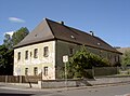
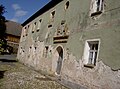
building in Mantel, Germany  | |||||
| Upload media | |||||
| Instance of | |||||
|---|---|---|---|---|---|
| Location | Mantel, Neustadt an der Waldnaab, Upper Palatinate, Bavaria, Germany | ||||
| Street address |
| ||||
| Heritage designation | |||||
 | |||||
This is the category of the Bavarian Baudenkmal (cultural heritage monument) with the ID D-3-74-134-3 (Wikidata)
|
Media in category "Forstamt Mantel"
The following 5 files are in this category, out of 5 total.
-
 MantelForstamt 01.jpg 2,304 × 1,704; 902 KB
-
 MantelForstamt 02.jpg 2,304 × 1,704; 791 KB
-
 MantelForstamt 03.jpg 2,304 × 1,704; 931 KB
-
 MantelForstamt 04.jpg 2,304 × 1,704; 940 KB
-
 MantelForstamt 05.jpg 2,304 × 1,704; 898 KB


