Category:Friedrich-Ebert-Straße 25 (Bonn)
Jump to navigation
Jump to search
| Object location | | View all coordinates using: OpenStreetMap |
|---|
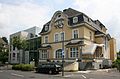
building in Bad Godesberg, Germany  | |||||
| Upload media | |||||
| Instance of | |||||
|---|---|---|---|---|---|
| Location | Bad Godesberg, Bonn, Cologne Government Region, North Rhine-Westphalia, Germany | ||||
| Located on street | |||||
| Heritage designation | |||||
 | |||||
| This category shows a heritage building in Germany, located in the North Rhine-Westphalian city Bonn (no. A 1718). |
Media in category "Friedrich-Ebert-Straße 25 (Bonn)"
The following 3 files are in this category, out of 3 total.
-
 2009-06-28 Bad Godesberg Augenklinik Dardenne.jpg 3,569 × 2,360; 3.59 MB
-
 Bad Godesberg, Friedrich-Ebert-Straße 25 1.jpg 3,322 × 2,838; 8.28 MB
-
 Bad Godesberg, Friedrich-Ebert-Straße 25.jpg 4,137 × 3,078; 11.89 MB

