Category:Fumarole Butte
Jump to navigation
Jump to search
shield volcano in Juab County, Utah, United States  | |||||
| Upload media | |||||
| Instance of | |||||
|---|---|---|---|---|---|
| Location | Juab County, Utah | ||||
| Topographic prominence |
| ||||
| Elevation above sea level |
| ||||
 | |||||
English: Media related to Fumarole Butte, a 5,259-foot (1,603 m) shield volcano on Crater Bench in central Juab County, Utah, United States. The butte is on the north-center, towards the northeast of the Sevier Desert, part of the landforms on the deserts northern perimeter; most are hills, or sections of mountain ranges. Fumarole Butte is a stand-alone exception, approximately circular, about 6 miles (9.7 km) in diameter.
Media in category "Fumarole Butte"
The following 3 files are in this category, out of 3 total.
-
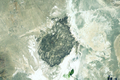 Fumarole Butte satellite.png 666 × 446; 694 KB
-
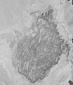 Fumarole Butte volcanic complex 1978 AR1VERD00020029.jpg 2,600 × 3,000; 952 KB
-
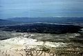 FumaroleButte USGS.jpg 400 × 271; 12 KB


Categories:
- Buttes of Utah
- Sevier Desert
- Crater Bench
- Mountains of the Great Basin (USA) in Utah
- Volcanoes in Utah
- Shield volcanoes in the United States
- Volcanic plugs in the United States
- 1600s mountains of the United States
- Bimodal volcanism in the United States
- Basalt volcanoes in the United States
- Rhyolite volcanoes in the United States
- Lava shields
- Pleistocene volcanoes in the United States