Category:Gabo Island
Jump to navigation
Jump to search
island located off the coast of eastern Victoria, Australia  Maják na ostrově Gabo na historické rytině | |||||
| Upload media | |||||
| Instance of | |||||
|---|---|---|---|---|---|
| Location | Pacific Ocean, international waters | ||||
| Located in or next to body of water | |||||
| Elevation above sea level |
| ||||
 | |||||
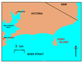
English: Gabo Island is a 154 ha island located off the coast of eastern Victoria, between Mallacoota and Cape Howe on the border with New South Wales. It is separated from the mainland by a 500 m wide channel; access is available by arranged flights and boats. Gabo Island is a shipping reference commonly referred to in Victorian weather warnings issued by the Australian Bureau of Meteorology. (→Gabo Island)
Français : L'île Gabo est une petite île située au large de la côte de l'est du Victoria, en Australie, entre Mallacoota et cap Howe à proximité de la frontière avec la Nouvelle-Galles du Sud. (→Île Gabo)
Media in category "Gabo Island"
The following 9 files are in this category, out of 9 total.
-

-
 Admiralty Chart No 1016 South coast of Australia Corner Inlet to Gabo Island, Published 1872.jpg 21,792 × 11,709; 81.68 MB
-
 Admiralty Chart No 1017 Gabo Island to Montagu Island, New South Wales, Published 1870.jpg 11,406 × 18,615; 67.35 MB
-
 Admiralty Chart No 1211 Australia Gabo Island to Port Jackson, Published 1888.jpg 8,234 × 12,360; 8.22 MB
-

-
 Admiralty Chart No 3169 Port Phillip to Gabo Island Australia, Published 1902.jpg 16,416 × 11,186; 60.31 MB
-
 GABOMAP.png 817 × 618; 32 KB
-
 Gabomap1.png 682 × 656; 25 KB
-
 Off Gabo Island (11863658903).jpg 1,772 × 1,772; 312 KB
_Corner_Inlet_to_Gabo_Island_Surveyed_by_Navg._Lieutt._H.J._Stanley_R.N._1871,_Published_1872.jpg)


.jpg)