Category:Gare de Dordives
Jump to navigation
Jump to search
| Object location | | View all coordinates using: OpenStreetMap |
|---|
railway station in Dordives, France  | |||||
| Upload media | |||||
| Instance of | |||||
|---|---|---|---|---|---|
| Location | Dordives, canton of Ferrières-en-Gâtinais | ||||
| Transport network | |||||
| Owned by | |||||
| Operator | |||||
| Elevation above sea level |
| ||||
| Connecting line | |||||
| Adjacent station | |||||
 | |||||
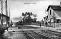
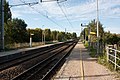
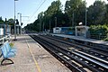
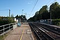
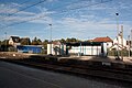
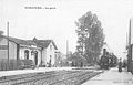
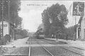
Français : La gare de Dordives est une gare ferroviaire française, de la ligne de Moret - Veneux-les-Sablons à Lyon-Perrache, située sur le territoire de la commune de Dordives, dans le département du Loiret, en région Centre.
Media in category "Gare de Dordives"
The following 19 files are in this category, out of 19 total.
-
 CPA colorisée Gare de Dordives Gillet 1900.jpg 1,010 × 665; 460 KB
-
 CPA Gare de Dordives ...eau 1900.jpg 1,227 × 818; 579 KB
-
 CPA Gare de Dordives Gillet-Fournier 1900.jpg 984 × 636; 390 KB
-
 CPA Gare de Dordives Leloup 1900.jpg 1,229 × 786; 543 KB
-
 CPA Gare de Dordives Leloup 1910.jpg 934 × 589; 386 KB
-
 CPA Gare de Dordives Leloup 1920.jpg 1,010 × 655; 500 KB
-
 Dordives IMG 0303.JPG 4,272 × 2,848; 1.5 MB
-
 Dordives IMG 0304.JPG 4,272 × 2,848; 1.57 MB
-
 Dordives IMG 0305.JPG 4,272 × 2,848; 2.11 MB
-
 Dordives IMG 0306.JPG 4,272 × 2,848; 1.92 MB
-
 Dordives IMG 0307.JPG 4,272 × 2,848; 1.93 MB
-
 Dordives IMG 0308.JPG 4,272 × 2,848; 1.91 MB
-
 Dordives IMG 0310.JPG 4,272 × 2,848; 1.76 MB
-
 Dordives IMG 0311.JPG 4,272 × 2,848; 1.63 MB
-
 Dordives IMG 0312.JPG 4,272 × 2,848; 1.4 MB
-
 Dordives IMG 0313.JPG 4,272 × 2,848; 1.5 MB
-
 Gare-de-Dordives-1.jpg 1,580 × 1,020; 1.3 MB
-
 Gare-de-Dordives-2.jpg 1,580 × 1,036; 1.55 MB
-
 Gare-de-Dordives-3.jpg 1,580 × 960; 1.35 MB


