Category:Gare de Romilly-sur-Seine
Jump to navigation
Jump to search
| Object location | | View all coordinates using: OpenStreetMap |
|---|
railway station in Romilly-sur-Seine, France  | |||||
| Upload media | |||||
| Instance of | |||||
|---|---|---|---|---|---|
| Location | Romilly-sur-Seine, canton of Romilly-sur-Seine-1 | ||||
| Transport network | |||||
| Owned by | |||||
| Operator | |||||
| Date of official opening |
| ||||
| Elevation above sea level |
| ||||
| Connecting line | |||||
| Adjacent station | |||||
 | |||||
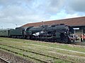
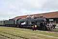
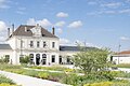
Français : La gare de Romilly-sur-Seine est une gare ferroviaire de la ligne de Paris-Est à Mulhouse, située à proximité du centre ville de Romilly-sur-Seine, dans le département de l'Aube en région Champagne-Ardenne.
Media in category "Gare de Romilly-sur-Seine"
The following 12 files are in this category, out of 12 total.
-
 241P17 - 52912047701.jpg 4,000 × 3,000; 2.3 MB
-
 241P17 - 52912196854.jpg 6,000 × 4,000; 6.73 MB
-
 241P17 - 52912429730.jpg 6,000 × 4,000; 7.41 MB
-
 241P17 - 52912501623.jpg 5,645 × 2,834; 13.88 MB
-
 34P325 - 52913815697.jpg 6,000 × 4,000; 6.3 MB
-
 34P325.jpg 4,000 × 3,000; 1.97 MB
-
 Gare SNCF Romilly sur Seine.jpg 3,406 × 2,270; 4.87 MB
-
 Gare SNCF Romilly-sur-Seine.jpg 1,845 × 1,230; 1.73 MB
-
 Romilly-sur-Seine - Station - 1.jpg 2,048 × 1,536; 846 KB
-
 Romilly-sur-Seine - Station - 2.jpg 2,048 × 1,536; 870 KB
-
 Romilly-sur-Seine - Station - 3.jpg 2,048 × 1,536; 598 KB
-
 Romilly-sur-Seine - Station - 4.jpg 2,048 × 1,536; 808 KB


