Category:Gare de Tessonnières
Jump to navigation
Jump to search
| Object location | | View all coordinates using: OpenStreetMap |
|---|
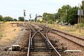
railway station in Gaillac, France  | |||||
| Upload media | |||||
| Instance of | |||||
|---|---|---|---|---|---|
| Location | Gaillac, Tarn, Occitania, Metropolitan France, France | ||||
| Transport network | |||||
| Owned by | |||||
| Operator | |||||
| Date of official opening |
| ||||
| Elevation above sea level |
| ||||
| Connecting line | |||||
| Adjacent station | |||||
 | |||||
Français : La gare de Tessonnières est une gare ferroviaire française des lignes de Brive-la-Gaillarde à Toulouse-Matabiau via Capdenac et de Tessonnières à Albi située quartier de Tessonnières sur le territoire de la commune de Gaillac, dans le département du Tarn, en région Midi-Pyrénées.
Media in category "Gare de Tessonnières"
The following 4 files are in this category, out of 4 total.
-
 BV de Tessonnières (1) par Cramos.JPG 4,000 × 2,250; 2.91 MB
-
 BV de Tessonnières (2) par Cramos.JPG 4,000 × 2,667; 1.97 MB
-
 Gare de Tessonnières par Cramos.JPG 4,000 × 2,667; 3.76 MB
-
 Gare de Tessonnières.jpg 2,048 × 1,536; 1.69 MB
_par_Cramos.JPG)
_par_Cramos.JPG)
