Category:Gare routière de Clermont-Ferrand
Jump to navigation
Jump to search
| Object location | | View all coordinates using: OpenStreetMap |
|---|
|
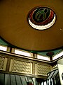
This building is inscrit au titre des monuments historiques de la France. It is indexed in the base Mérimée, a database of architectural heritage maintained by the French Ministry of Culture, under the reference PA63000081
|
 | |||||
| Upload media | |||||
| Instance of | |||||
|---|---|---|---|---|---|
| Location | Clermont-Ferrand, Puy-de-Dôme, Auvergne-Rhône-Alpes, Metropolitan France, France | ||||
| Street address |
| ||||
| Architect |
| ||||
| Heritage designation |
| ||||
| Date of official opening |
| ||||
 | |||||
Media in category "Gare routière de Clermont-Ferrand"
The following 7 files are in this category, out of 7 total.
-
 LeDuc gare routiere 03.jpg 600 × 800; 401 KB
-
 LeDuc gare routiere 04.jpg 600 × 800; 386 KB
-
 LeDuc gare routiere 08.jpg 800 × 600; 348 KB
-
 LeDuc GR 210306 10.jpg 800 × 600; 301 KB
-
 LeDuc GR 210306 22.jpg 600 × 800; 389 KB
-
 LeDuc mdc 101005 06.jpg 800 × 600; 399 KB
-
 LeDuc mdc 101005 07.jpg 600 × 800; 441 KB


