Category:Geography of Pennsylvania
Vai alla navigazione
Vai alla ricerca
Stati degli USA: Alabama · Alaska · Arizona · Arkansas · California · Carolina del Nord · Carolina del Sud · Colorado · Connecticut · Dakota del Nord · Dakota del Sud · Delaware · Florida · Georgia · Hawaii · Idaho · Illinois · Indiana · Iowa · Kansas · Kentucky · Louisiana · Maine · Maryland · Massachusetts · Michigan · Minnesota · Mississippi · Missouri · Montana · Nebraska · Nevada · New Hampshire · New Jersey · New York · Nuovo Messico · Ohio · Oklahoma · Oregon · Pennsylvania · Rhode Island · Tennessee · Texas · Utah · Vermont · Virginia · Virginia Occidentale · Washington · Wisconsin · Wyoming – Distretto di Columbia: Washington
aree insulari degli Stati Uniti d'America: Guam · Isole Marianne Settentrionali · Isole Vergini Americane · Porto Rico · Samoa Americane – Atollo di Midway · Atollo Johnston · isola Baker · isola di Wake · Isola Howland · isola Jarvis · isola Navassa · Kingman Reef · Palmyra
aree insulari degli Stati Uniti d'America: Guam · Isole Marianne Settentrionali · Isole Vergini Americane · Porto Rico · Samoa Americane – Atollo di Midway · Atollo Johnston · isola Baker · isola di Wake · Isola Howland · isola Jarvis · isola Navassa · Kingman Reef · Palmyra
overview of the geography of the state of Pennsylvania in the northeastern US | |||||
| Carica un file multimediale | |||||
| Istanza di |
| ||||
|---|---|---|---|---|---|
| Sottoclasse di | |||||
| Aspetto di | |||||
| Luogo |
| ||||
| |||||
Sottocategorie
Questa categoria contiene le 24 sottocategorie indicate di seguito, su un totale di 24.
File nella categoria "Geography of Pennsylvania"
Questa categoria contiene 40 file, indicati di seguito, su un totale di 40.
-
 1646 - Bethel Twp - View from PA643 near Pleasant Grove Rd.JPG 4 000 × 2 620; 1,95 MB
-
 1659 - Brush Creek Twp - View from PA643 near Old PA126.JPG 4 000 × 3 000; 2,17 MB
-
 1660 - Brush Creek Twp - View from PA643 near Old PA126.JPG 3 905 × 2 860; 1,54 MB
-
 1877PaMap-Right-150r.png 1 889 × 2 427; 2,63 MB
-
 1907 Taneytown Road.png 472 × 1 479; 1,47 MB
-
 2007 06 01 - View from I99 a.JPG 2 589 × 381; 132 KB
-
 2007 06 01 - View from I99 b.JPG 2 589 × 521; 183 KB
-
 2007 06 01 - View from I99 c.JPG 2 581 × 397; 134 KB
-
 2007 06 01 - View from I99 d.JPG 2 557 × 293; 75 KB
-
 82 Mile Stone.jpg 3 024 × 4 032; 4,69 MB
-
 Above Ticklish Rock.jpg 3 000 × 4 000; 3,22 MB
-
 Allegheny County High Point.jpg 4 928 × 3 264; 3,93 MB
-
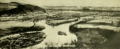
 Bedford-co-air.jpg 1 024 × 593; 265 KB
-
 Camp lohikan1.jpg 448 × 336; 27 KB
-
 Capital City Airport - PA - 13 April 1999.jpg 833 × 767; 279 KB
-
 Chandler field-2.jpg 400 × 272; 33 KB
-
 Chestnut Ridge Bedford Co aerial.jpg 683 × 519; 203 KB
-
 Endless Mountains 1756 map.jpg 1 200 × 900; 1,51 MB
-
 Farmland in Pennsylvania.jpg 2 816 × 2 112; 2,88 MB
-
 Garrett-hill-july-4.JPG 2 592 × 1 944; 1,94 MB
-
 Geologic cross section of Devonian strata from New York to Alabama.svg 1 000 × 500; 221 KB
-
 Glacial Lake beaches of the Lake Erie Basin.JPG 871 × 631; 68 KB
-
 Jesse Robinson House Wellsboro PA Oct 09.JPG 2 592 × 1 944; 575 KB
-
 Johnstown Rockfall 1.JPG 2 975 × 2 125; 4,01 MB
-
 Johnstown Rockfall 2.JPG 2 363 × 1 684; 606 KB
-
 Juniata River meander.jpg 870 × 862; 189 KB
-
 MP overlook.jpg 1 500 × 1 125; 1,32 MB
-
 Olmsted Air National Guard Base - May 1979.jpg 3 600 × 2 700; 2,84 MB
-
 Penn-York Valley Old River View.png 835 × 343; 496 KB
-
 Pennsylvania swine flu map.svg 4 950 × 2 846; 107 KB
-
 PortGriffith2.jpeg 480 × 320; 36 KB
-
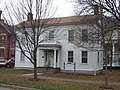 Robinson House Wellsboro PA Oct 09.JPG 2 592 × 1 944; 723 KB
-
 ThousandSteps.JPG 3 648 × 2 736; 2,26 MB
-
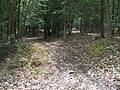 Ticklish Rock Trailhead.jpg 4 000 × 3 000; 4,52 MB
-
 Ticklish Rock.jpg 3 000 × 4 000; 3,92 MB
-
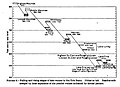
 USGS 2006 1237 Fig7b.png 1 713 × 709; 138 KB
-
 Wave win.jpg 1 024 × 768; 209 KB
-
 WLCarriageHouse.JPG 1 632 × 1 224; 512 KB
-
 Wreaths at Ticklish Rock.jpg 3 000 × 4 000; 5,34 MB
-
 Yough Gorge.jpg 1 722 × 1 139; 963 KB


