Category:Geography of Pennsylvania
Sari la navigare
Sari la căutare
States of the United States: Alabama · Alaska · Arizona · Arkansas · California · Carolina de Nord · Carolina de Sud · Colorado · Connecticut · Dakota de Nord · Dakota de Sud · Delaware · Florida · Georgia · Hawaii · Idaho · Illinois · Indiana · Iowa · Kansas · Kentucky · Louisiana · Maine · Maryland · Massachusetts · Michigan · Minnesota · Mississippi · Missouri · Montana · Nebraska · Nevada · New Hampshire · New Jersey · New Mexico · New York · Ohio · Oklahoma · Oregon · Pennsylvania · Rhode Island · Tennessee · Texas · Utah · Vermont · Virginia · Virginia de Vest · Washington · Wisconsin · Wyoming – Districtul Columbia: Washington, D.C.
the insular areas of the United States: Comunitatea Insulelor Mariane de Nord · Guam · Insulele Virgine Americane · Puerto Rico · Samoa Americană – Atolul Johnston · Atolul Midway · Atolul Palmyra · Insula Baker · Insula Howland · Insula Jarvis · Insula Navassa · Insula Wake · Reciful Kingman
the insular areas of the United States: Comunitatea Insulelor Mariane de Nord · Guam · Insulele Virgine Americane · Puerto Rico · Samoa Americană – Atolul Johnston · Atolul Midway · Atolul Palmyra · Insula Baker · Insula Howland · Insula Jarvis · Insula Navassa · Insula Wake · Reciful Kingman
overview of the geography of the state of Pennsylvania in the northeastern US | |||||
| Încarcă multimedia | |||||
| Este un/o |
| ||||
|---|---|---|---|---|---|
| Subclasă a | |||||
| Fațetă a | |||||
| Locul actual |
| ||||
| |||||
Subcategorii
Această categorie conține următoarele 24 de subcategorii, dintr-un total de 24.
Fișiere media din categoria „Geography of Pennsylvania”
Următoarele 40 fișiere se află în această categorie, dintr-un total de 40.
-
 1646 - Bethel Twp - View from PA643 near Pleasant Grove Rd.JPG 4.000x2.620; 1,95 MB
-
 1659 - Brush Creek Twp - View from PA643 near Old PA126.JPG 4.000x3.000; 2,17 MB
-
 1660 - Brush Creek Twp - View from PA643 near Old PA126.JPG 3.905x2.860; 1,54 MB
-
 1877PaMap-Right-150r.png 1.889x2.427; 2,63 MB
-
 1907 Taneytown Road.png 472x1.479; 1,47 MB
-
 2007 06 01 - View from I99 a.JPG 2.589x381; 132 KB
-
 2007 06 01 - View from I99 b.JPG 2.589x521; 183 KB
-
 2007 06 01 - View from I99 c.JPG 2.581x397; 134 KB
-
 2007 06 01 - View from I99 d.JPG 2.557x293; 75 KB
-
 82 Mile Stone.jpg 3.024x4.032; 4,69 MB
-
 Above Ticklish Rock.jpg 3.000x4.000; 3,22 MB
-
 Allegheny County High Point.jpg 4.928x3.264; 3,93 MB
-
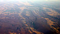 Bedford-co-air.jpg 1.024x593; 265 KB
-
 Camp lohikan1.jpg 448x336; 27 KB
-
 Capital City Airport - PA - 13 April 1999.jpg 833x767; 279 KB
-
 Chandler field-2.jpg 400x272; 33 KB
-
 Chestnut Ridge Bedford Co aerial.jpg 683x519; 203 KB
-
 Endless Mountains 1756 map.jpg 1.200x900; 1,51 MB
-
 Farmland in Pennsylvania.jpg 2.816x2.112; 2,88 MB
-
 Garrett-hill-july-4.JPG 2.592x1.944; 1,94 MB
-
 Geologic cross section of Devonian strata from New York to Alabama.svg 1.000x500; 221 KB
-
 Glacial Lake beaches of the Lake Erie Basin.JPG 871x631; 68 KB
-
 Jesse Robinson House Wellsboro PA Oct 09.JPG 2.592x1.944; 575 KB
-
 Johnstown Rockfall 1.JPG 2.975x2.125; 4,01 MB
-
 Johnstown Rockfall 2.JPG 2.363x1.684; 606 KB
-
 Juniata River meander.jpg 870x862; 189 KB
-
 MP overlook.jpg 1.500x1.125; 1,32 MB
-
 Olmsted Air National Guard Base - May 1979.jpg 3.600x2.700; 2,84 MB
-
 Penn-York Valley Old River View.png 835x343; 496 KB
-
 Pennsylvania swine flu map.svg 4.950x2.846; 107 KB
-
 PortGriffith2.jpeg 480x320; 36 KB
-
 Robinson House Wellsboro PA Oct 09.JPG 2.592x1.944; 723 KB
-
 ThousandSteps.JPG 3.648x2.736; 2,26 MB
-
 Ticklish Rock Trailhead.jpg 4.000x3.000; 4,52 MB
-
 Ticklish Rock.jpg 3.000x4.000; 3,92 MB
-
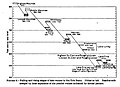
 USGS 2006 1237 Fig7b.png 1.713x709; 138 KB
-
 Wave win.jpg 1.024x768; 209 KB
-
 WLCarriageHouse.JPG 1.632x1.224; 512 KB
-
 Wreaths at Ticklish Rock.jpg 3.000x4.000; 5,34 MB
-
 Yough Gorge.jpg 1.722x1.139; 963 KB


