Category:Geography of Sudan
Sari la navigare
Sari la căutare
geographical features of Sudan   | |||||
| Încarcă multimedia | |||||
| Este un/o |
| ||||
|---|---|---|---|---|---|
| Subclasă a | |||||
| Fațetă a | |||||
| Locul actual |
| ||||
 | |||||
Subcategorii
Această categorie conține următoarele 14 subcategorii, dintr-un total de 14.
+
B
E
F
- Forests of Sudan (1 F)
G
- Gezira Scheme (1 P, 6 F)
L
M
N
- Nubian Sandstone Aquifer System (13 F)
P
T
W
Fișiere media din categoria „Geography of Sudan”
Următoarele 10 fișiere se află în această categorie, dintr-un total de 10.
-
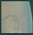 AS09-20-3177 (21938300995).jpg 4.400x4.600; 815 KB
-
 Equatoria 1882-1885.jpg 1.031x1.272; 1,49 MB
-
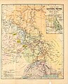
 Equatoria in 1882; its 10 districts.png 950x1.018; 372 KB
-
 GolfvonAdenKartevonDanielPresberger.png 800x668; 145 KB
-
 Incoming Sandstorm.jpg 960x1.280; 169 KB
-
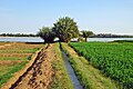
 Karima agriculture.jpg 3.900x2.613; 1,94 MB
-
 Karima nile.jpg 1.920x1.285; 654 KB
-
 L'Égypte et la géographie.pdf 1.275 × 1.650, 113 pagini; 2,24 MB
-
 Memorandum of the spelling of place names in the Sudan.pdf 1.275 × 1.650, 5 pagini; 186 KB
-
 Sudan´s Red Sea litoral.jpg 3.151x1.772; 1,35 MB
.jpg)


