Category:Geography of the Canary Islands
Przejdź do nawigacji
Przejdź do wyszukiwania
Autonomous communities of Spain: Andaluzja · Aragonia · Asturia · Baleary · Kraj Basków · Wyspy Kanaryjskie · Kantabria · Kastylia i León · Kastylia-La Mancha · Katalonia · Estremadura · Galicja · Madryt · Murcja · Nawarra · La Rioja · Walencja · Autonomous cities: Ceuta · Melilla

Geography of the Canary Islands.
| Prześlij plik multimedialny | |||||
| Jest to |
| ||||
|---|---|---|---|---|---|
| Podklasa dla | |||||
| |||||
Podkategorie
Poniżej wyświetlono 27 spośród wszystkich 27 podkategorii tej kategorii.
*
+
?
B
C
E
F
- Fields in the Canary Islands (18 plików)
L
P
R
S
T
- Trig points in the Canary Islands (14 plików)
W
Pliki w kategorii „Geography of the Canary Islands”
Poniżej wyświetlono 11 spośród wszystkich 11 plików w tej kategorii.
-
 Bev entw kanaren.png 917 × 595; 35 KB
-
 Bevolkerungsentwicklung Kanaren.jpg 943 × 608; 89 KB
-
 Canaryislands tmo 2013166 lrg(2).jpg 2600 × 2000; 1006 KB
-
 Chinamada-Roque los Pinos.JPG 640 × 480; 157 KB
-
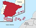 Mapa de España (alternativo).jpg 1611 × 1288; 465 KB
-
 Mapa de España.jpg 2475 × 1288; 537 KB
-
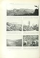 Nouvellegograp02granuoft 0324.jpg 2309 × 3336; 775 KB
-
 Steps to the sea. (27752939787).jpg 3601 × 2404; 11,46 MB
-
 The Shadow (27153408057).jpg 2794 × 1906; 4,99 MB
-
 The woman among the rocks (44029093372).jpg 6016 × 4016; 15,2 MB
-
 Vista de La Graciosa.jpg 5880 × 1584; 2 MB


.jpg)

.jpg)


.jpg)
.jpg)
.jpg)