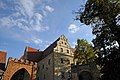
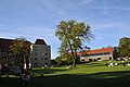
Category:Gola Dzierżoniowska Castle
Jump to navigation
Jump to search
| Object location | | View all coordinates using: OpenStreetMap |
|---|
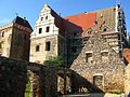
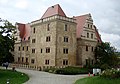
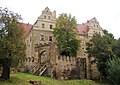
historical castle in Lower Silesian Voivodeship, Poland  | |||||
| Upload media | |||||
| Instance of | |||||
|---|---|---|---|---|---|
| Location | Gmina Niemcza, Dzierżoniów County, Lower Silesian Voivodeship, Poland | ||||
| Architectural style | |||||
| official website | |||||
 | |||||
Polski: Zamek w Goli Dzierżoniowskiej
Deutsch: Schloss Guhlau
English: Gola Dzierżoniowska Castle
Español: Castillo de Gola Dzierżoniowska
Français : Château de Gola Dzierżoniowska
Nederlands: Kasteel van Gola Dzierżoniowska
Media in category "Gola Dzierżoniowska Castle"
The following 24 files are in this category, out of 24 total.
-
 Gola Caste Etat Actuel.jpg 684 × 513; 116 KB
-
 Gola castle arch 2.jpg 2,560 × 1,440; 1.83 MB
-
 Gola castle arch.jpg 1,440 × 2,560; 1.33 MB
-
 Gola Castle Etat Initial.jpg 900 × 343; 81 KB
-
 Gola Castle.jpg 680 × 510; 86 KB
-
 Gola Dzierzoniowska (castle).jpg 3,648 × 2,736; 2.02 MB
-
 Gola Dzierż portal.jpg 1,440 × 2,560; 2.53 MB
-
 Gola Dzierżoniowska - Brama.jpg 2,592 × 3,456; 2.81 MB
-
 Gola Dzierżoniowska - elewacja od strony parku.jpg 3,456 × 2,592; 3.08 MB
-
 Gola Dzierżoniowska - widok od strony parku.jpg 3,455 × 2,420; 2.02 MB
-
 Gola Dzierżoniowska - zamek.jpg 3,331 × 2,366; 2.01 MB
-
 Gola Dzierżoniowska.JPG 2,048 × 1,536; 637 KB
-
 Gola Portal.jpg 428 × 600; 84 KB
-
 Herb von Borwitz.jpg 444 × 514; 64 KB
-
 Herb von Eichholz.jpg 332 × 380; 49 KB
-
 Herb von Pogrel.jpg 416 × 532; 54 KB
-
 Herb von Rohnau.jpg 313 × 387; 41 KB
-
 Herb von von Nassau 1 (2).jpg 792 × 944; 113 KB
-
 Zamek Gola Dzierżoniowska.jpg 4,288 × 2,848; 3.77 MB
-
 Zamek Gola Dzierżoniowska02.jpg 4,288 × 2,848; 3.49 MB
-
 Zamek Gola Dzierżoniowska03.jpg 2,848 × 4,288; 5.25 MB
-
 Zamek Gola Dzierżoniowska04.jpg 4,288 × 2,848; 3.59 MB
-
 Zamek Gola Dzierżoniowska05.jpg 2,848 × 4,288; 3.75 MB
-
 Zamek w Goli Dzierżoniowskiej.jpg 4,163 × 2,341; 3.04 MB


.jpg)


.jpg)


