Category:Graaf van Burenstraat 9, Deventer
Jump to navigation
Jump to search
| Object location | | View all coordinates using: OpenStreetMap |
|---|
house in Deventer, Netherlands  | |||||
| Upload media | |||||
| Instance of | |||||
|---|---|---|---|---|---|
| Location | Deventer, Overijssel, Netherlands | ||||
| Street address |
| ||||
| Located on street | |||||
| Heritage designation |
| ||||
 | |||||
|
This is a category about rijksmonument number 46564
|
| Address |
|
Media in category "Graaf van Burenstraat 9, Deventer"
The following 31 files are in this category, out of 31 total.
-
 Exterieur ACHTERGEVEL - Deventer - 20296958 - RCE.jpg 1,193 × 1,200; 381 KB
-
 Exterieur LETTERS OP VOORGEVEL, DETAIL - Deventer - 20296956 - RCE.jpg 1,200 × 1,188; 406 KB
-
 Exterieur OVERZICHT - Deventer - 20296953 - RCE.jpg 1,195 × 1,200; 331 KB
-
 Exterieur OVERZICHT VOORGEVELS - Deventer - 20296954 - RCE.jpg 1,190 × 1,200; 375 KB
-
 Exterieur PROFIEL DAKLIJST - Deventer - 20296957 - RCE.jpg 1,200 × 1,200; 272 KB
-
 Exterieur STOEP - Deventer - 20296959 - RCE.jpg 1,192 × 1,200; 368 KB
-
 Exterieur VOORGEVEL, DETAIL LETTERS - Deventer - 20296955 - RCE.jpg 1,200 × 1,192; 410 KB
-
 Graaf van Burenstraat 9 Deventer.jpg 640 × 428; 32 KB
-
 INTERIEUR, BEGANE GROND, DETAIL VENSTER - Deventer - 20296965 - RCE.jpg 1,190 × 1,200; 300 KB
-
 INTERIEUR, BEGANE GROND, OVERZICHT KAMER - Deventer - 20296961 - RCE.jpg 1,197 × 1,200; 343 KB
-
 INTERIEUR, BEGANE GROND, OVERZICHT KAMER - Deventer - 20296962 - RCE.jpg 1,200 × 1,200; 337 KB
-
 INTERIEUR, BEGANE GROND, OVERZICHT TRAP - Deventer - 20296967 - RCE.jpg 1,190 × 1,200; 296 KB
-
 INTERIEUR, BEGANE GROND, VENSTER - Deventer - 20296963 - RCE.jpg 1,197 × 1,200; 329 KB
-
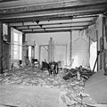
 INTERIEUR, EERSTE VERDIEPING, LINKER GEDEELTE (GESLOOPT) - Deventer - 20296970 - RCE.jpg 1,188 × 1,200; 364 KB
-
 INTERIEUR, EERSTE VERDIEPING, LINKER GEDEELTE (GESLOOPT) - Deventer - 20296971 - RCE.jpg 1,185 × 1,200; 398 KB
-
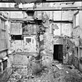 INTERIEUR, EERSTE VERDIEPING, LINKER GEDEELTE (GESLOOPT) - Deventer - 20296972 - RCE.jpg 1,188 × 1,200; 439 KB
-
 INTERIEUR, EERSTE VERDIEPING, OVERZICHT RECHTER KAMER - Deventer - 20296968 - RCE.jpg 1,184 × 1,200; 262 KB
-
 INTERIEUR, EERSTE VERDIEPING, OVERZICHT RECHTER KAMER - Deventer - 20296969 - RCE.jpg 1,195 × 1,200; 290 KB
-
 INTERIEUR, EERSTE VERDIEPING, RAAM IN ACHTERGEVEL - Deventer - 20296973 - RCE.jpg 1,190 × 1,200; 299 KB
-
 INTERIEUR, EERSTE VERDIEPING, TRAPPENHUIS - Deventer - 20296974 - RCE.jpg 1,181 × 1,200; 304 KB
-
 INTERIEUR, GIETIJZEREN RAAM (NEO-GOTISCH) IN ACHTERGEVEL - Deventer - 20296964 - RCE.jpg 1,200 × 1,192; 239 KB
-
 INTERIEUR, NATUURSTENEN RAAMDORPEL - Deventer - 20296966 - RCE.jpg 1,200 × 1,197; 379 KB
-
 INTERIEUR, OVERZICHT KELDER - Deventer - 20296977 - RCE.jpg 1,195 × 1,200; 302 KB
-
 INTERIEUR, VENSTERBANK, DETAIL - Deventer - 20296960 - RCE.jpg 1,200 × 1,188; 278 KB
-
 INTERIEUR, ZOLDER, KAP MET HIJSWERKTUIG - Deventer - 20296976 - RCE.jpg 1,188 × 1,200; 342 KB
-
 INTERIEUR, ZOLDER, OVERZICHT KAPCONSTRUCTIE - Deventer - 20296975 - RCE.jpg 1,195 × 1,200; 328 KB
-
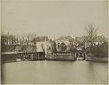
 Overzicht - Deventer - 20055856 - RCE.jpg 1,200 × 946; 226 KB
-
 Stoep - Deventer - 20055859 - RCE.jpg 951 × 1,200; 222 KB
-
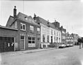 Voorgevels - Deventer - 20055857 - RCE.jpg 1,200 × 932; 223 KB
-
 Voorgevels - Deventer - 20055858 - RCE.jpg 1,200 × 948; 226 KB
-


_-_Deventer_-_20296970_-_RCE.jpg)
_-_Deventer_-_20296971_-_RCE.jpg)
_-_Deventer_-_20296972_-_RCE.jpg)


_IN_ACHTERGEVEL_-_Deventer_-_20296964_-_RCE.jpg)


