Category:Grafton, Wiltshire
Jump to navigation
Jump to search
English: Grafton is a village and civil parish in the east of the English county of Wiltshire. Strictly the village is East Grafton, and the parish also includes the hamlets of West Grafton, Marten, Wexcombe, Wilton and Wolfhall. In the Census 2001, the parish had a population of 604. Grafton had a station on the Midland and South Western Junction Railway until closure in 1961.
Nederlands: Grafton is een civil parish in de unitary authority Wiltshire, in het Engelse graafschap Wiltshire. De civil parish telt
civil parish in Wiltshire, England  | |||||
| Upload media | |||||
| Instance of | |||||
|---|---|---|---|---|---|
| Location | Wiltshire, South West England, England | ||||
| official website | |||||
 | |||||
Subcategories
This category has the following 4 subcategories, out of 4 total.
Media in category "Grafton, Wiltshire"
The following 200 files are in this category, out of 387 total.
(previous page) (next page)-
 267 and 268, Grafton - geograph.org.uk - 2625299.jpg 3,648 × 2,736; 2.18 MB
-
 A Chair at Crofton - geograph.org.uk - 5403669.jpg 1,188 × 1,600; 581 KB
-

-
 A Roman road - geograph.org.uk - 4263257.jpg 640 × 480; 92 KB
-
 A338 approaches crossroads at Piccadilly - geograph.org.uk - 2987487.jpg 3,461 × 2,483; 1.3 MB
-
 A338 approaches East Grafton - geograph.org.uk - 3387501.jpg 3,594 × 2,667; 2.49 MB
-
-
 A338 between West and East Grafton - geograph.org.uk - 2987370.jpg 3,354 × 2,467; 1.84 MB
-
 A338 climbs the downs north of Marten - geograph.org.uk - 2987407.jpg 3,648 × 2,484; 1.55 MB
-
 A338 enters East Grafton - geograph.org.uk - 2987377.jpg 3,396 × 2,551; 2.43 MB
-
 A338 junction with Hollow Lane - geograph.org.uk - 2625989.jpg 3,283 × 2,376; 1.5 MB
-
 A338 junction with Wexcombe Road - geograph.org.uk - 2987404.jpg 3,558 × 2,692; 1.3 MB
-
 A338 north of Kingstone Farm - geograph.org.uk - 2987357.jpg 3,504 × 2,577; 2.56 MB
-
 A338 south of Severalls - geograph.org.uk - 2987384.jpg 3,507 × 2,419; 1.24 MB
-
 A338 southeast of Wilton - geograph.org.uk - 2987398.jpg 3,647 × 2,692; 1.54 MB
-

-
 Along the summit of Fair Mile - geograph.org.uk - 6099425.jpg 1,024 × 683; 237 KB
-
 Appletree Cottage - geograph.org.uk - 2626007.jpg 3,648 × 2,736; 3.91 MB
-

-
 Arable field northeast of Roman Road - geograph.org.uk - 2626048.jpg 3,648 × 2,736; 1.99 MB
-
 Arable fields near East Grafton - geograph.org.uk - 3103488.jpg 2,288 × 1,712; 1.23 MB
-

-
 Bales not Rails - geograph.org.uk - 6089587.jpg 1,600 × 1,067; 326 KB
-
 Behind the hedge, Dark Lane - geograph.org.uk - 4263406.jpg 640 × 480; 97 KB
-
 Boat on Kennet and Avon Canal - geograph.org.uk - 5968505.jpg 1,024 × 681; 166 KB
-
 Bridge over the Kennet and Avon Canal - geograph.org.uk - 4238005.jpg 1,600 × 1,064; 513 KB
-
 Bridleway and footpath, Southgrove Copse - geograph.org.uk - 1229467.jpg 640 × 480; 155 KB
-
 Bridleway past Southgrove Copse - geograph.org.uk - 1229333.jpg 640 × 480; 122 KB
-

-
 Burbage, Former route of the MandSWJR - geograph.org.uk - 1405042.jpg 640 × 480; 116 KB
-
 Byway and farmland, Grafton - geograph.org.uk - 6090825.jpg 1,024 × 768; 231 KB
-
 Canal feeder - geograph.org.uk - 4644349.jpg 640 × 426; 32 KB
-
 Canal feeder - geograph.org.uk - 4644350.jpg 640 × 426; 56 KB
-
 Canal feeder - geograph.org.uk - 4886019.jpg 640 × 426; 48 KB
-
 Canal feeder - geograph.org.uk - 5193283.jpg 640 × 426; 41 KB
-
 Canal feeder - geograph.org.uk - 5193285.jpg 640 × 426; 37 KB
-
 Canal feeder - geograph.org.uk - 5458101.jpg 640 × 426; 33 KB
-
 Canal feeder - geograph.org.uk - 5458104.jpg 640 × 426; 35 KB
-
 Canal feeder - geograph.org.uk - 5564073.jpg 640 × 426; 58 KB
-
 Canal feeder - geograph.org.uk - 5564075.jpg 640 × 426; 54 KB
-
 Canal feeder - geograph.org.uk - 5564077.jpg 640 × 426; 54 KB
-
 Canal feeder - geograph.org.uk - 5660522.jpg 640 × 426; 52 KB
-
 Canal feeder - geograph.org.uk - 5660523.jpg 640 × 426; 54 KB
-
 Canal feeder - geograph.org.uk - 5688420.jpg 640 × 426; 68 KB
-
 Canal feeder - geograph.org.uk - 5688422.jpg 640 × 426; 70 KB
-
 Canal feeder - geograph.org.uk - 5782631.jpg 640 × 303; 37 KB
-
 Canal feeder - geograph.org.uk - 5914486.jpg 1,024 × 681; 119 KB
-
 Canal feeder - geograph.org.uk - 5914488.jpg 1,024 × 681; 129 KB
-
 Canal feeder - geograph.org.uk - 6058493.jpg 1,024 × 681; 203 KB
-
 Canal feeder - geograph.org.uk - 6058497.jpg 1,024 × 681; 173 KB
-
 Canal feeder - geograph.org.uk - 6058499.jpg 1,024 × 681; 225 KB
-
 Canal feeder - geograph.org.uk - 6058502.jpg 1,024 × 681; 174 KB
-
 Canal feeder and farmland - geograph.org.uk - 4644345.jpg 640 × 426; 38 KB
-
 Carr on the north-east bank of Wilton Water - geograph.org.uk - 4495244.jpg 1,024 × 768; 231 KB
-
 Catch Points - geograph.org.uk - 3777905.jpg 1,048 × 1,578; 580 KB
-
 Chalk track, Wexcombe, Wiltshire - geograph.org.uk - 4435828.jpg 573 × 800; 214 KB
-
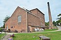
 Chimney, Crofton Beam Engine - geograph.org.uk - 6058522.jpg 1,024 × 727; 119 KB
-
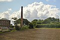
 Chimney, Crofton Pumping Station - geograph.org.uk - 4644355.jpg 383 × 640; 46 KB
-
 Church of St Nicholas at East Grafton - geograph.org.uk - 6099474.jpg 1,024 × 683; 200 KB
-
 Cottage next to the Railway crossing - geograph.org.uk - 3334123.jpg 4,108 × 3,648; 3.14 MB
-
 Cottage on The Green - geograph.org.uk - 2625290.jpg 3,648 × 2,736; 1.81 MB
-
 Cottages, Wexcombe - geograph.org.uk - 4393185.jpg 640 × 480; 162 KB
-
 Country Lane, Wexcombe, Wiltshire - geograph.org.uk - 4437926.jpg 800 × 796; 295 KB
-
 Covered reservoir, north of Wilton - geograph.org.uk - 4495195.jpg 1,024 × 768; 134 KB
-
 Crofton - Railway Line - geograph.org.uk - 2832103.jpg 800 × 600; 154 KB
-
 Crofton Crossing - geograph.org.uk - 5250675.jpg 1,024 × 768; 148 KB
-

-
 Crofton Curve - geograph.org.uk - 3777914.jpg 1,538 × 968; 674 KB
-
 Crofton level crossing - geograph.org.uk - 2759023.jpg 640 × 427; 99 KB
-
 Crofton level crossing - geograph.org.uk - 3361510.jpg 640 × 427; 97 KB
-
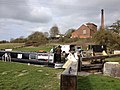
 Crofton Locks - geograph.org.uk - 3138594.jpg 640 × 424; 268 KB
-
 Crofton Locks - geograph.org.uk - 3138888.jpg 640 × 424; 251 KB
-
 Crofton Locks - geograph.org.uk - 5868055.jpg 1,024 × 681; 199 KB
-
 Crofton Locks - geograph.org.uk - 5868058.jpg 1,024 × 572; 117 KB
-
 Crofton Locks - geograph.org.uk - 5968506.jpg 1,024 × 604; 158 KB
-
 Crofton Pumping Station - beam gallery - geograph.org.uk - 3138970.jpg 640 × 424; 279 KB
-
 Crofton Pumping Station - Chimney - geograph.org.uk - 3138899.jpg 640 × 424; 275 KB
-
 Crofton Pumping Station - cylinder head - geograph.org.uk - 3138954.jpg 640 × 424; 269 KB
-

-
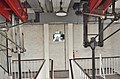 Crofton Pumping Station - Engines - geograph.org.uk - 3138944.jpg 640 × 424; 245 KB
-
 Crofton Pumping Station - geograph.org.uk - 2757349.jpg 427 × 640; 79 KB
-
 Crofton Pumping Station - geograph.org.uk - 3049045.jpg 640 × 427; 91 KB
-
 Crofton Pumping Station - geograph.org.uk - 3138610.jpg 640 × 424; 238 KB
-
 Crofton Pumping Station - geograph.org.uk - 3138903.jpg 640 × 424; 251 KB
-
 Crofton Pumping Station - geograph.org.uk - 4185858.jpg 3,166 × 2,312; 1.59 MB
-
 Crofton Pumping Station - geograph.org.uk - 5250665.jpg 1,024 × 751; 185 KB
-
 Crofton Pumping Station - geograph.org.uk - 5688410.jpg 640 × 426; 62 KB
-
 Crofton Pumping Station - geograph.org.uk - 6099444.jpg 683 × 1,024; 199 KB
-
 Crofton Pumping Station - Wilton Water - geograph.org.uk - 3138891.jpg 424 × 640; 254 KB
-
 Crofton Pumping Station and Wilton Water - geograph.org.uk - 4495258.jpg 1,024 × 768; 114 KB
-
 Crofton Pumping Station from the lock - geograph.org.uk - 2880532.jpg 640 × 480; 138 KB
-
 Crofton pumping station from the south east - geograph.org.uk - 3268507.jpg 1,000 × 675; 461 KB
-
-

-
 Crofton, footpath - geograph.org.uk - 5250639.jpg 1,024 × 769; 216 KB
-
 Crofton, Freewarren Bridge - geograph.org.uk - 6166478.jpg 1,024 × 792; 189 KB
-
 Crofton, Lock No 60 - geograph.org.uk - 5250651.jpg 1,024 × 768; 134 KB
-
 Crofton, Lock No 61 - geograph.org.uk - 5250668.jpg 1,024 × 768; 140 KB
-
 Crofton, sluice - geograph.org.uk - 5250647.jpg 1,024 × 768; 161 KB
-
 Dark Lane enters East Grafton - geograph.org.uk - 4263428.jpg 640 × 480; 144 KB
-
 Dark Lane south of Freewarren Farm - geograph.org.uk - 2625271.jpg 3,636 × 2,534; 1.94 MB
-
 Dark Lane south of Marten - geograph.org.uk - 1248960.jpg 640 × 480; 132 KB
-
 Downland, Wexcombe, Wiltshire - geograph.org.uk - 4435849.jpg 662 × 800; 185 KB
-
 Ducks on Wilton Water - geograph.org.uk - 4172119.jpg 4,608 × 3,456; 5.55 MB
-
 Early evening sunlight at Wilton Water - geograph.org.uk - 4172113.jpg 4,608 × 3,456; 5.59 MB
-

-
 East Grafton, Dark Lane - geograph.org.uk - 1404868.jpg 640 × 480; 135 KB
-
 Farm track on former railway line, West Grafton - geograph.org.uk - 6099948.jpg 1,024 × 683; 285 KB
-
 Farming hillside - geograph.org.uk - 5914492.jpg 1,024 × 681; 114 KB
-
 Farming near Crofton Locks - geograph.org.uk - 5688421.jpg 640 × 426; 78 KB
-
 Farmland above Wexcombe - geograph.org.uk - 1561770.jpg 640 × 480; 149 KB
-
 Farmland and pylon, Grafton - geograph.org.uk - 1561760.jpg 640 × 480; 150 KB
-
 Farmland and pylon, Grafton - geograph.org.uk - 4373344.jpg 640 × 480; 129 KB
-
 Farmland and track, Grafton - geograph.org.uk - 4373311.jpg 640 × 480; 233 KB
-
 Farmland and track, Grafton - geograph.org.uk - 4373360.jpg 640 × 480; 162 KB
-
-
 Farmland east of Grafton - geograph.org.uk - 5435156.jpg 1,024 × 781; 146 KB
-
 Farmland near East Grafton - geograph.org.uk - 1595631.jpg 640 × 479; 329 KB
-
 Farmland north of Wilton Windmill - geograph.org.uk - 4495234.jpg 1,024 × 768; 123 KB
-
 Farmland south of Marten - geograph.org.uk - 1248948.jpg 640 × 480; 125 KB
-
 Farmland west of Wilton Down - geograph.org.uk - 1252369.jpg 640 × 480; 133 KB
-
 Farmland, Grafton - geograph.org.uk - 1561774.jpg 640 × 480; 130 KB
-
 Farmland, Grafton - geograph.org.uk - 2921301.jpg 640 × 480; 183 KB
-
 Farmland, Grafton - geograph.org.uk - 4373320.jpg 640 × 480; 188 KB
-
 Farmland, Grafton - geograph.org.uk - 4373324.jpg 640 × 480; 240 KB
-
 Farmland, Grafton - geograph.org.uk - 4373329.jpg 640 × 480; 171 KB
-
 Farmland, Grafton - geograph.org.uk - 4373353.jpg 640 × 480; 169 KB
-
 Farmland, Grafton - geograph.org.uk - 4373369.jpg 640 × 480; 232 KB
-
 Farmland, Grafton - geograph.org.uk - 4373384.jpg 640 × 480; 222 KB
-
 Farmland, Grafton - geograph.org.uk - 6087660.jpg 1,024 × 768; 294 KB
-
 Farmland, Marten - geograph.org.uk - 1561792.jpg 640 × 480; 159 KB
-
 Farmland, Marten - geograph.org.uk - 738235.jpg 640 × 480; 98 KB
-
 Farmland, Wexcombe - geograph.org.uk - 1561783.jpg 640 × 480; 154 KB
-
 Field beside Wolfhall Road - geograph.org.uk - 6099957.jpg 1,024 × 683; 160 KB
-
 Field by Piccadilly, Marten - geograph.org.uk - 6212041.jpg 1,920 × 1,280; 1.23 MB
-
 Field by Piccadilly, Marten - geograph.org.uk - 6212046.jpg 1,920 × 1,280; 1.08 MB
-
 Field near Crofton - geograph.org.uk - 5918322.jpg 1,024 × 681; 96 KB
-
 Field near Freewarren Bridge - geograph.org.uk - 5688418.jpg 640 × 426; 50 KB
-
 Fields and power grid lines near Marten - geograph.org.uk - 3034939.jpg 2,592 × 1,944; 1.41 MB
-
 Fields near Marten - geograph.org.uk - 3034948.jpg 2,592 × 1,944; 1.72 MB
-
 Fields south-east of Marten - geograph.org.uk - 4263217.jpg 640 × 480; 108 KB
-
 Footpath above Marten - geograph.org.uk - 738245.jpg 640 × 480; 130 KB
-
 Footpath from the Roman road to Wilton - geograph.org.uk - 4495240.jpg 1,024 × 768; 137 KB
-
 Footpath passing Lock No. 61 - geograph.org.uk - 3262400.jpg 1,024 × 768; 1.12 MB
-
-
 Freewarren Bridge - geograph.org.uk - 2757386.jpg 640 × 427; 127 KB
-
 Freewarren Bridge - geograph.org.uk - 3777867.jpg 1,566 × 1,044; 859 KB
-
 Freewarren Bridge - geograph.org.uk - 5383445.jpg 640 × 426; 56 KB
-

-
 Freewarren Bridge, Kennet and Avon Canal - geograph.org.uk - 414611.jpg 640 × 537; 109 KB
-
 Freewarren Farm - geograph.org.uk - 5024980.jpg 640 × 426; 44 KB
-
 Freewarren Farm - geograph.org.uk - 5383448.jpg 640 × 426; 43 KB
-
 Freight Train at Crofton - geograph.org.uk - 2991430.jpg 1,024 × 682; 935 KB
-
 Gate on footpath at East Grafton - geograph.org.uk - 6099469.jpg 1,024 × 683; 332 KB
-
 Gate onto the Towpath - geograph.org.uk - 6089594.jpg 5,152 × 3,864; 2.83 MB
-
 Geese on the Kennet and Avon canal near Crofton - geograph.org.uk - 666764.jpg 1,024 × 768; 1.15 MB
-
 Goods train at Crofton, Wiltshire - geograph.org.uk - 2156098.jpg 1,600 × 1,200; 494 KB
-
 Grafton Place, East Grafton - geograph.org.uk - 6205679.jpg 1,872 × 1,204; 1.2 MB
-
 Great Western Mainline - geograph.org.uk - 3138894.jpg 640 × 424; 267 KB
-
 Great Western Mainline - geograph.org.uk - 3138897.jpg 640 × 424; 281 KB
-
 Great Western Railway at Crofton - geograph.org.uk - 2758949.jpg 640 × 427; 111 KB
-
 Great Western Railway at Crofton - geograph.org.uk - 2758954.jpg 640 × 427; 119 KB
-
 Highway to the sun, Marten - geograph.org.uk - 1248259.jpg 640 × 480; 155 KB
-
 Hillside near Wilton - geograph.org.uk - 5403620.jpg 3,888 × 2,592; 2.06 MB
-
 Hillside sheep, west of Crofton - geograph.org.uk - 3705380.jpg 1,024 × 768; 158 KB
-
 Horsing around - geograph.org.uk - 506544.jpg 640 × 480; 424 KB
-
 In place of a phone - geograph.org.uk - 2823421.jpg 427 × 640; 85 KB
-

-

-
 Island on Wilton Water - geograph.org.uk - 4172111.jpg 4,608 × 3,456; 5.28 MB
-

-
 Jogger on the towpath at Crofton - geograph.org.uk - 3700435.jpg 1,024 × 768; 172 KB
-
 Kennet , Kennet ^ Avon Canal - geograph.org.uk - 2588489.jpg 2,560 × 1,920; 2.42 MB
-
 Kennet and Avon Canal - geograph.org.uk - 3138596.jpg 640 × 424; 254 KB
-
 Kennet and Avon Canal - geograph.org.uk - 3138599.jpg 640 × 424; 249 KB
-
 Kennet and Avon Canal - geograph.org.uk - 3138600.jpg 640 × 424; 224 KB
-
 Kennet and Avon Canal - geograph.org.uk - 3138602.jpg 640 × 424; 240 KB
-
 Kennet and Avon Canal - geograph.org.uk - 3138606.jpg 640 × 424; 223 KB
-
 Kennet and Avon Canal at Crofton - geograph.org.uk - 2284189.jpg 1,600 × 1,043; 497 KB
-
 Kennet and Avon canal at Crofton - geograph.org.uk - 3592579.jpg 640 × 480; 81 KB
-
 Kennet and Avon Canal at Crofton - geograph.org.uk - 6099447.jpg 1,024 × 683; 153 KB
-

-
 Kennet and Avon Canal near Freewarren Bridge - geograph.org.uk - 3103466.jpg 2,288 × 1,712; 1.28 MB
-
 Kennet and Avon Lock number 58 - geograph.org.uk - 2625255.jpg 3,648 × 2,736; 3.27 MB
-
 Kennet ^ Avon canal below lock 56 - geograph.org.uk - 3705366.jpg 1,024 × 768; 142 KB
-
 Kennet ^ Avon canal feeder stream - geograph.org.uk - 3371589.jpg 5,472 × 3,648; 4.13 MB
-
 Kennet ^ Avon Canal near Crofton - geograph.org.uk - 6091084.jpg 4,955 × 3,430; 1.9 MB
-
 Kennet ^ Avon canal towpath - geograph.org.uk - 3705362.jpg 1,024 × 768; 192 KB
-
 Kennet ^ Avon canal towpath, looking west - geograph.org.uk - 3705372.jpg 1,024 × 768; 156 KB
-
 Kennet ^ Avon Canal Walk - geograph.org.uk - 5647986.jpg 640 × 480; 100 KB
-
 Kennet ^ Avon Canal Walk - geograph.org.uk - 5647992.jpg 640 × 480; 73 KB
-
 Kennet ^ Avon Canal Walk - geograph.org.uk - 5648013.jpg 640 × 480; 87 KB
-

-
 Lane at the junction of Piccadilly - geograph.org.uk - 6211006.jpg 1,920 × 1,280; 1.43 MB
-
 Lane in Marten, Wiltshire - geograph-2626026.jpg 3,648 × 2,736; 1.57 MB
-
 Lane towards Wolfhall Manor - geograph.org.uk - 4393227.jpg 640 × 480; 135 KB
-
 Lane ^ Cables, Crofton - geograph.org.uk - 6091075.jpg 4,553 × 3,402; 1.45 MB
-
 Large arable field - geograph.org.uk - 4886010.jpg 640 × 426; 31 KB
-
 Late afternoon across the tracks - geograph.org.uk - 3340510.jpg 4,893 × 3,598; 5.48 MB
-
 Lichen on a railway bridge brickwork - geograph.org.uk - 2758961.jpg 640 × 427; 126 KB


