Category:Graven 11, Deventer
Jump to navigation
Jump to search
| Object location | | View all coordinates using: OpenStreetMap |
|---|
 | |||||
| Upload media | |||||
| Instance of |
| ||||
|---|---|---|---|---|---|
| Location | Deventer, Overijssel, Netherlands | ||||
| Street address |
| ||||
| Located on street | |||||
| Heritage designation |
| ||||
 | |||||
|
This is a category about rijksmonument number 12548
|
| Address |
|
Media in category "Graven 11, Deventer"
The following 8 files are in this category, out of 8 total.
-
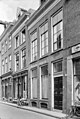 Gevels - Deventer - 20055865 - RCE.jpg 805 × 1,200; 226 KB
-
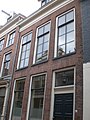 Graven 11.JPG 2,304 × 3,072; 3.99 MB
-
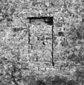
 INTERIEUR, MUUR (XIII EEUW) - Deventer - 20294968 - RCE.jpg 1,190 × 1,200; 393 KB
-
 INTERIEUR, MUUR, DETAIL - Deventer - 20294969 - RCE.jpg 1,188 × 1,200; 379 KB
-
 INTERIEUR, MUUR, DETAIL - Deventer - 20294970 - RCE.jpg 1,181 × 1,200; 525 KB
-
 INTERIEUR, MUUR, DETAIL - Deventer - 20294971 - RCE.jpg 1,197 × 1,200; 474 KB
-
 INTERIEUR, MUUR, DETAIL - Deventer - 20294972 - RCE.jpg 1,197 × 1,200; 445 KB
-
 INTERIEUR, MUUR, DETAIL - Deventer - 20294973 - RCE.jpg 1,197 × 1,200; 385 KB

_-_Deventer_-_20294968_-_RCE.jpg)


