Category:Great Canfield
Jump to navigation
Jump to search

Great Canfield is a village and a civil parish in the Uttlesford district of Essex, England. The parish contains the hamlets and small settlements of Hope End Green, Hellmans Cross, Bacon End, Baconend Green, and Puttocks End.
village in Essex, England, UK | |||||
| Upload media | |||||
| Instance of | |||||
|---|---|---|---|---|---|
| Location | Uttlesford, Essex, East of England, England | ||||
| Said to be the same as | Great Canfield (Wikimedia duplicated page, civil parish) | ||||
 | |||||
Subcategories
This category has the following 8 subcategories, out of 8 total.
- St Mary's Church, Great Canfield (63 F)
B
- Bacon End (6 F)
- Baconend Green (2 F)
C
- Great Canfield Castle (3 F)
H
- Hellman's Cross (28 F)
- Hope End Green (6 F)
P
- Puttock's End (1 F)
Media in category "Great Canfield"
The following 63 files are in this category, out of 63 total.
-
 1881 Great Canfield Occupational Percentage Pie Chart.jpg 706 × 476; 120 KB
-
 'Crataegus' hawthorn tree blossom at Great Canfield, Essex, England.jpg 3,500 × 2,333; 5.69 MB
-
 Bench outside the churchyard of St Mary's Church, Great Canfield.jpg 3,500 × 2,333; 9 MB
-
 House on Church End, Great Canfield, Essex, England.jpg 3,500 × 2,333; 6.17 MB
-
 Houses on Church End, Great Canfield, Essex, England.jpg 3,500 × 2,333; 6.7 MB
-
 Logpile on Church End, Great Canfield, Essex, England.jpg 3,500 × 2,333; 7.55 MB
-
 Daffodils in Great Canfield, Essex England.jpg 5,112 × 3,408; 9.24 MB
-
 Narcissus in Great Canfield, Essex England.jpg 3,899 × 2,599; 6.12 MB
-
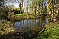
 Pond in Great Canfield, Essex England 01.jpg 4,160 × 6,240; 27.31 MB
-
 Pond in Great Canfield, Essex England 02.jpg 6,240 × 4,160; 30.9 MB
-
 Roadside stream in Great Canfield, Essex, England.jpg 4,160 × 6,240; 21.56 MB
-
 Great Canfield, Fitzjohns Lane, in Essex England.jpg 4,160 × 6,240; 29.46 MB
-
 Great Canfield, barn on Green Street, in Essex England.jpg 6,198 × 4,132; 28.89 MB
-
 Great Canfield, Black Hall on Green Street, in Essex England.jpg 6,087 × 4,058; 24.71 MB
-
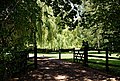
 Entrance drive to Perses Taverners Green Great Canfield Essex 1.jpg 5,685 × 3,972; 21.49 MB
-
 Entrance drive to Perses Taverners Green Great Canfield Essex 2.jpg 6,136 × 4,160; 24.34 MB
-
 Entrance drive to Perses Taverners Green Great Canfield Essex 3.jpg 6,074 × 4,050; 22.77 MB
-
 Great Canfield, pond Fitzjohns Lane Essex England.jpg 4,608 × 3,456; 27.06 MB
-
 Great Canfield, stream bridge Fitzjohns Lane Essex England.jpg 4,608 × 3,456; 26.84 MB
-
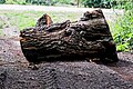 Great Canfield, tree trunk barrier Fitzjohns Lane Essex England.jpg 3,945 × 2,630; 15.58 MB
-
 30 limit on Canfield Road - geograph.org.uk - 3534485.jpg 640 × 480; 133 KB
-
 Bacon End Cottages - geograph.org.uk - 4753151.jpg 4,318 × 3,238; 6.22 MB
-
 Boxley Lane - geograph.org.uk - 4594906.jpg 640 × 480; 158 KB
-
 Canfield Drive - geograph.org.uk - 1710387.jpg 640 × 429; 170 KB
-
 Canfield Road - geograph.org.uk - 1710405.jpg 640 × 429; 142 KB
-
 Canfield Road - geograph.org.uk - 1710430.jpg 640 × 429; 150 KB
-
 Canfield Road - geograph.org.uk - 1710512.jpg 429 × 640; 148 KB
-
 Canfield Road - geograph.org.uk - 1710521.jpg 640 × 429; 153 KB
-
 Canfield Road - geograph.org.uk - 3534439.jpg 640 × 480; 152 KB
-
 Canfield Road near Great Canfield Park - geograph.org.uk - 1710345.jpg 429 × 640; 175 KB
-
 Canfield Road near Great Canfield Park - geograph.org.uk - 1710355.jpg 640 × 429; 158 KB
-
 Canfield Road near Great Canfield Park - geograph.org.uk - 1710529.jpg 640 × 429; 210 KB
-
 Cuckoo Cottage, Hellman's Cross, Essex - geograph.org.uk - 3476162.jpg 3,968 × 2,232; 4.16 MB
-

-
 Eastwards - geograph.org.uk - 3349947.jpg 640 × 466; 67 KB
-

-
 Field at Great Canfield Park - geograph.org.uk - 1710377.jpg 640 × 429; 138 KB
-
 Field at Great Canfield Park - geograph.org.uk - 1710393.jpg 640 × 429; 110 KB
-
 Field at Great Canfield Park - geograph.org.uk - 1710396.jpg 640 × 429; 116 KB
-
 Field at Great Canfield Park - geograph.org.uk - 1710418.jpg 640 × 429; 143 KB
-
 Field by Dunmow Road, Bacon End - geograph.org.uk - 5611218.jpg 1,899 × 1,407; 913 KB
-
 Fields near to Gilmans - geograph.org.uk - 3349948.jpg 640 × 464; 64 KB
-
 Fields south of High Cross Lane - geograph.org.uk - 3349958.jpg 640 × 462; 55 KB
-
 Fine old country house - geograph.org.uk - 2399137.jpg 640 × 425; 100 KB
-
 Fitzjohns Lane meets Green Street - geograph.org.uk - 3534528.jpg 640 × 480; 138 KB
-
 Footbridge to High Roding - geograph.org.uk - 515578.jpg 426 × 640; 143 KB
-
 Footpath at Great Canfield Park - geograph.org.uk - 1710327.jpg 429 × 640; 214 KB
-
 Footpath at Great Canfield Park - geograph.org.uk - 1710338.jpg 429 × 640; 203 KB
-
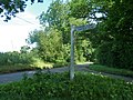
 Footpath marker - geograph.org.uk - 1710537.jpg 429 × 640; 207 KB
-
 Great Canfield 2011 Occupational Data.jpg 527 × 355; 74 KB
-
 Great Canfield civil parish, Essex 1945.PNG 813 × 726; 1.16 MB
-
 Great Canfield from the air - geograph.org.uk - 2412111.jpg 640 × 480; 155 KB
-
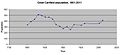 Great canfield population.jpg 684 × 311; 20 KB
-
 Houses, Great Canfield (geograph 3534610).jpg 640 × 480; 100 KB
-
 Lane to Marsh Farm - geograph.org.uk - 3534576.jpg 640 × 480; 157 KB
-
 Little Bullocks Farm Bed ^ Breakfast - geograph.org.uk - 2522260.jpg 3,648 × 2,736; 2.14 MB
-
 Little Bullocks Farm, Hope End Green, Takely, Essex - geograph.org.uk - 3476141.jpg 3,968 × 2,232; 4.22 MB
-
 Northwards - geograph.org.uk - 3349949.jpg 640 × 469; 70 KB
-
 Passing Black Hall - geograph.org.uk - 3349951.jpg 640 × 472; 81 KB
-

-
 Pond by Peckers Farm, Great Canfield - geograph.org.uk - 1753678.jpg 800 × 600; 156 KB
-
 Towards Great Canfield - geograph.org.uk - 3349952.jpg 640 × 485; 96 KB
-
 Westwards - geograph.org.uk - 3349950.jpg 640 × 459; 64 KB


.jpg)


