Category:Grimston, Leicestershire
Jump to navigation
Jump to search
English: Grimston is a village and civil parish in the Melton district, in the county of Leicestershire, England. It is governed by Grimston, Saxelby and Shoby parish council
village in Leicestershire, England, UK  | |||||
| Upload media | |||||
| Instance of | |||||
|---|---|---|---|---|---|
| Location | Grimston, Melton, Leicestershire, East Midlands, England | ||||
 | |||||
Subcategories
This category has the following 3 subcategories, out of 3 total.
Media in category "Grimston, Leicestershire"
The following 200 files are in this category, out of 308 total.
(previous page) (next page)-
 'Belvoir Angel' gravestone, Grimston - geograph.org.uk - 3872692.jpg 1,280 × 960; 434 KB
-

-
 A corner of Grimston Church - geograph.org.uk - 3872708.jpg 960 × 1,280; 420 KB
-
 A field of field beans - geograph.org.uk - 2082876.jpg 640 × 452; 64 KB
-
 A twisty A6006 heading east - geograph.org.uk - 3608517.jpg 640 × 480; 73 KB
-
 A6006 bend, east of Shoby - geograph.org.uk - 3604334.jpg 640 × 480; 62 KB
-
 A6006 east of Scholes Farm - geograph.org.uk - 3604294.jpg 640 × 481; 72 KB
-
 A6006 eastbound near Shoby - geograph.org.uk - 3604309.jpg 640 × 480; 70 KB
-
 A6006 heading east - geograph.org.uk - 3608511.jpg 640 × 480; 68 KB
-
 A6006 heading towards Melton Mowbray - geograph.org.uk - 3608515.jpg 640 × 480; 89 KB
-

-
-
 A6006 towards Loughborough - geograph.org.uk - 5925078.jpg 640 × 439; 52 KB
-
 A6006 towards Loughborough - geograph.org.uk - 5925085.jpg 640 × 423; 46 KB
-
 A6006 towards Melton Mowbray - geograph.org.uk - 5925079.jpg 640 × 451; 72 KB
-
 A6006 towards Melton Mowbray - geograph.org.uk - 5925086.jpg 640 × 421; 44 KB
-

-
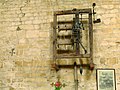
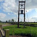
 Air vent, Grimston Tunnel - geograph.org.uk - 4454759.jpg 1,280 × 960; 437 KB
-
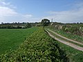
 Along the hedge - geograph.org.uk - 2631369.jpg 640 × 528; 103 KB
-

-
 Aylesford X-Country Course entrance - geograph.org.uk - 5925087.jpg 640 × 438; 45 KB
-
 Aylesford X-Country Course sign - geograph.org.uk - 5925088.jpg 640 × 471; 95 KB
-
 Bales in a field - geograph.org.uk - 1067592.jpg 640 × 449; 75 KB
-
 Barn conversion, Grimston (geograph 6936643).jpg 1,024 × 768; 150 KB
-
 Barn Farm, Grimston - geograph.org.uk - 1265178.jpg 640 × 480; 111 KB
-
 Behind the hedge - geograph.org.uk - 2631386.jpg 640 × 486; 102 KB
-
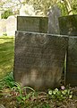
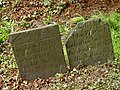
 Belvoir Angel headstone, Grimston Churchyard - geograph.org.uk - 4454763.jpg 1,280 × 960; 501 KB
-
 Belvoir Angel headstone, Grimston Churchyard - geograph.org.uk - 4454767.jpg 1,280 × 960; 507 KB
-
 Belvoir Angel headstone, Grimston Churchyard - geograph.org.uk - 4454776.jpg 1,280 × 960; 479 KB
-
 Belvoir Angel headstone, Saxelbye Churchyard - geograph.org.uk - 4429498.jpg 960 × 1,280; 349 KB
-
 Belvoir Angel headstone, Saxelbye Churchyard - geograph.org.uk - 4429503.jpg 960 × 1,280; 338 KB
-
 Belvoir Angel headstone, Saxelbye Churchyard - geograph.org.uk - 4429508.jpg 919 × 1,280; 358 KB
-
 Belvoir Angel headstone, Saxelbye Churchyard - geograph.org.uk - 4429511.jpg 960 × 1,280; 389 KB
-
 Belvoir Angel headstones, Grimston Churchyard - geograph.org.uk - 4454772.jpg 1,280 × 960; 556 KB
-
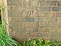 Bench mark, Saxelbye railway bridge - geograph.org.uk - 4429447.jpg 1,280 × 960; 461 KB
-
 Bridleway heading west - geograph.org.uk - 3608520.jpg 640 × 480; 75 KB
-
 Bridleway to Grimston - geograph.org.uk - 1265136.jpg 640 × 480; 86 KB
-
 Brook Farm, Saxelbye - geograph.org.uk - 2356503.jpg 480 × 640; 108 KB
-
 Brook Farmhouse, Saxelbye - geograph.org.uk - 4429482.jpg 960 × 1,280; 451 KB
-
 By Saxelbye Park - geograph.org.uk - 1301011.jpg 640 × 488; 96 KB
-

-
 Cattle and pasture near Shoby - geograph.org.uk - 3167954.jpg 2,181 × 1,523; 1.27 MB
-

-
 Church Cottage, Grimston - geograph.org.uk - 3872688.jpg 1,280 × 960; 370 KB
-
 Church Farm, Grimston - geograph.org.uk - 3872682.jpg 1,280 × 932; 327 KB
-
 Church Farm, Saxelbye (geograph 6937708).jpg 1,024 × 768; 195 KB
-
 Church Farmhouse, Grimston (geograph 6939869).jpg 1,024 × 768; 195 KB
-
 Church farmhouse, Saxelbye - geograph.org.uk - 4429553.jpg 1,280 × 960; 404 KB
-
 Church of St John the Baptist - geograph.org.uk - 4464120.jpg 2,000 × 1,500; 453 KB
-
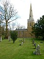
 Church of St John the Baptist, Grimston - geograph.org.uk - 3872686.jpg 1,280 × 960; 515 KB
-
 Church of St John the Baptist, Grimston - geograph.org.uk - 3872711.jpg 1,280 × 890; 258 KB
-
 Church of St John the Baptist, Grimston - geograph.org.uk - 4454790.jpg 1,280 × 1,280; 344 KB
-
 Church of St John the Baptist, Grimston - geograph.org.uk - 4454792.jpg 1,280 × 886; 292 KB
-
 Church of St John the Baptist, Grimston - geograph.org.uk - 4454794.jpg 1,280 × 960; 343 KB
-
 Church of St John the Baptist, Grimston - geograph.org.uk - 4454795.jpg 1,280 × 960; 357 KB
-
 Church of St John the Baptist, Grimston - geograph.org.uk - 4454797.jpg 1,280 × 1,280; 333 KB
-
 Church of St John the Baptist, Grimston - geograph.org.uk - 4454798.jpg 1,280 × 1,280; 310 KB
-
 Church of St Peter, Saxelbye - geograph.org.uk - 4429519.jpg 960 × 1,280; 300 KB
-
 Church of St Peter, Saxelbye - geograph.org.uk - 4429522.jpg 960 × 1,280; 340 KB
-
 Church of St Peter, Saxelbye - geograph.org.uk - 4429535.jpg 1,280 × 1,280; 572 KB
-

-
 Country lane ascending Green Hill - geograph.org.uk - 909633.jpg 578 × 640; 70 KB
-
 Country lane near Saxelbye - geograph.org.uk - 909668.jpg 640 × 412; 99 KB
-
 Country lane to Saxelbye - geograph.org.uk - 909662.jpg 640 × 466; 90 KB
-
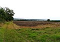
 Crop field off Six Hills Lane - geograph.org.uk - 3608543.jpg 640 × 480; 63 KB
-
 Crop field off the A6006 - geograph.org.uk - 3608509.jpg 640 × 480; 88 KB
-
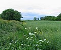
 Crop field towards Saxelbye Wood - geograph.org.uk - 3608539.jpg 640 × 480; 71 KB
-
 Cycling along Perkin's Lane - geograph.org.uk - 909643.jpg 640 × 525; 106 KB
-
 Derelict building in a field - geograph.org.uk - 2000461.jpg 640 × 474; 89 KB
-
 Edge of the wood southwards - geograph.org.uk - 5412668.jpg 640 × 471; 85 KB
-
 Electricity substation building - geograph.org.uk - 5015748.jpg 640 × 422; 72 KB
-
 Electricity supply poles - geograph.org.uk - 5015749.jpg 640 × 638; 102 KB
-

-
 Entrance to Grimston - geograph.org.uk - 3575398.jpg 640 × 462; 88 KB
-
 Entrance to Grimston - geograph.org.uk - 3872493.jpg 1,280 × 935; 313 KB
-
 Entrance to Old Dalby reservoir - geograph.org.uk - 5015750.jpg 640 × 498; 101 KB
-
 Entrance to Saxelbye - geograph.org.uk - 3575389.jpg 640 × 480; 72 KB
-
 Entrance to Shoby Trout Club - geograph.org.uk - 2631360.jpg 640 × 464; 60 KB
-
 Farm track and bridleway - geograph.org.uk - 5925111.jpg 640 × 411; 45 KB
-

-
 Farm track heading south - geograph.org.uk - 3608541.jpg 640 × 480; 114 KB
-
 Farm track near Shoby - geograph.org.uk - 3167962.jpg 3,264 × 2,448; 3.25 MB
-
 Farm track near the A6006 - geograph.org.uk - 3167944.jpg 3,264 × 2,448; 3.42 MB
-
 Farm track off the A6006 - geograph.org.uk - 3608513.jpg 640 × 480; 77 KB
-
 Farmland and woodland - geograph.org.uk - 3608519.jpg 640 × 480; 75 KB
-
 Farmland near Grimston - geograph.org.uk - 3608530.jpg 640 × 480; 80 KB
-

-

-
 Farmland off the A6006 - geograph.org.uk - 3608512.jpg 640 × 480; 67 KB
-
 Field and hedge by Perkin's Lane - geograph.org.uk - 5015751.jpg 640 × 481; 81 KB
-
 Field by lane - geograph.org.uk - 2082885.jpg 640 × 480; 128 KB
-
 Field edge eastwards - geograph.org.uk - 2082878.jpg 640 × 503; 107 KB
-
 Field edge westwards - geograph.org.uk - 2082877.jpg 640 × 430; 93 KB
-
 Fields opposite Shoby Lodge Farm - geograph.org.uk - 2631377.jpg 640 × 441; 58 KB
-
 Fire hydrant at Shoby turn off on A6006 - geograph.org.uk - 5925113.jpg 640 × 512; 148 KB
-

-
 Footpath and bridleway sign - geograph.org.uk - 2825646.jpg 640 × 588; 39 KB
-
 Footpath by the woods - geograph.org.uk - 2631389.jpg 640 × 490; 145 KB
-

-
 Footpath gate - geograph.org.uk - 5925089.jpg 640 × 467; 71 KB
-
 Footpath near Grimston - geograph.org.uk - 3872492.jpg 1,280 × 960; 253 KB
-
 Footpath off Perkin's Lane - geograph.org.uk - 3608531.jpg 640 × 480; 74 KB
-
 Footpath over fields - geograph.org.uk - 3608525.jpg 640 × 480; 107 KB
-
 Footpath to Ragdale - geograph.org.uk - 5925090.jpg 640 × 433; 55 KB
-
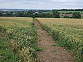
 Footpath towards Grimston - geograph.org.uk - 3608508.jpg 640 × 480; 99 KB
-
 Footpath towards Grimston - geograph.org.uk - 5453271.jpg 640 × 505; 93 KB
-

-
 Footpath towards Melton Mowbray - geograph.org.uk - 2000462.jpg 640 × 475; 65 KB
-
 Footpath towards Wartnaby - geograph.org.uk - 5453272.jpg 640 × 492; 109 KB
-
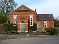 Former Methodist Church, Grimston - geograph.org.uk - 2830105.jpg 640 × 480; 108 KB
-
 Former schoolroom, Saxelbye (geograph 6936681).jpg 1,024 × 779; 247 KB
-
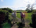 Friendly horses - geograph.org.uk - 5015788.jpg 640 × 498; 91 KB
-
 Gap in hedge - geograph.org.uk - 2082881.jpg 640 × 486; 131 KB
-
 Gas equipment covers - geograph.org.uk - 5015789.jpg 640 × 467; 173 KB
-
 Gate and field track - geograph.org.uk - 5925091.jpg 640 × 445; 68 KB
-
 Gate and track - geograph.org.uk - 5925080.jpg 640 × 430; 48 KB
-
 Gate for Midshires Way towards Hoby - geograph.org.uk - 5925115.jpg 640 × 502; 88 KB
-

-

-
 Gate on track through to the A6006 - geograph.org.uk - 5925118.jpg 640 × 482; 85 KB
-
 Gates and track - geograph.org.uk - 2825643.jpg 640 × 480; 57 KB
-
 Gates and track - geograph.org.uk - 5925074.jpg 640 × 445; 45 KB
-
 Gateway into a field by Shoby - geograph.org.uk - 2631378.jpg 640 × 479; 88 KB
-
 Gateway to road - geograph.org.uk - 2082880.jpg 640 × 445; 88 KB
-
 Glebe Farm - geograph.org.uk - 1067593.jpg 640 × 480; 91 KB
-
 Glebe Farm and farmland - geograph.org.uk - 3146836.jpg 2,630 × 2,080; 2.23 MB
-
 Gorse Farm - geograph.org.uk - 4454756.jpg 1,280 × 957; 421 KB
-
 Gravestones at Grimston - geograph.org.uk - 3872701.jpg 1,280 × 960; 460 KB
-
 Grimston Green - geograph.org.uk - 3872494.jpg 1,280 × 960; 467 KB
-
 Grimston Main Street - geograph.org.uk - 3872659.jpg 1,280 × 960; 321 KB
-
 Grimston Main Street - geograph.org.uk - 909646.jpg 640 × 420; 87 KB
-
 Grimston old school - geograph.org.uk - 3872495.jpg 1,280 × 960; 280 KB
-
 Grimston postbox ref LE14 3 - geograph.org.uk - 3872722.jpg 960 × 1,280; 418 KB
-
 Grimston Village Hall - geograph.org.uk - 3872728.jpg 1,280 × 952; 301 KB
-
 Grimston, aerial 2018 - geograph.org.uk - 5846124.jpg 533 × 800; 112 KB
-
 Hedge cutting at Shoby bends - geograph.org.uk - 5925100.jpg 640 × 481; 94 KB
-
 Horse jump - geograph.org.uk - 2631361.jpg 640 × 454; 73 KB
-
 Horse jump - geograph.org.uk - 2631362.jpg 640 × 594; 98 KB
-
 Houses in Saxelbye Lane, Grimston - geograph.org.uk - 2830119.jpg 640 × 480; 106 KB
-
 Into Shoby - geograph.org.uk - 5925119.jpg 640 × 456; 66 KB
-
-
 Lane heading north through Shoby - geograph.org.uk - 3608523.jpg 640 × 480; 83 KB
-
 Leicestershire landscape - geograph.org.uk - 4455832.jpg 1,280 × 721; 187 KB
-

-
 Local Transformer 1679 - geograph.org.uk - 5015752.jpg 640 × 480; 72 KB
-
 Looking east along the A6006 - geograph.org.uk - 3167894.jpg 2,066 × 1,720; 1.27 MB
-

-
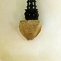
 Medieval cross, Grimston - geograph.org.uk - 3872706.jpg 1,280 × 960; 419 KB
-
 Medieval cross, Grimston churchyard - geograph.org.uk - 4454780.jpg 1,280 × 1,280; 607 KB
-
 Methodist Chapel - geograph.org.uk - 3872726.jpg 1,280 × 975; 351 KB
-
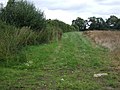
 Midshires Way - geograph.org.uk - 2631380.jpg 640 × 496; 78 KB
-
 Midshires Way near Shoby - geograph.org.uk - 3167971.jpg 3,264 × 2,448; 3.01 MB
-
 Minor road heading north - geograph.org.uk - 3608547.jpg 640 × 480; 95 KB
-
 Morning ride - geograph.org.uk - 1067588.jpg 640 × 511; 107 KB
-

-
 Notice on telecommunications cabinet - geograph.org.uk - 5015754.jpg 640 × 455; 59 KB
-
 Notices, Saxelbye railway bridge - geograph.org.uk - 4429460.jpg 933 × 1,280; 402 KB
-
 Oil Seed Rape - geograph.org.uk - 2631363.jpg 640 × 507; 101 KB
-
 Oil seed rape - geograph.org.uk - 2631370.jpg 640 × 457; 92 KB
-
 Old Dalby Wood House gateway to driveway - geograph.org.uk - 5015756.jpg 640 × 424; 133 KB
-
 Old Dalby Wood House sign - geograph.org.uk - 5015757.jpg 640 × 517; 131 KB
-
 Old sink upside down in field - geograph.org.uk - 5925081.jpg 640 × 458; 74 KB
-
 Old sink upside down in field - geograph.org.uk - 5925082.jpg 640 × 418; 92 KB
-
 Ostler Lane southwards - geograph.org.uk - 5015790.jpg 640 × 457; 119 KB
-
 Ostler Lane towards Nether Broughton - geograph.org.uk - 5015782.jpg 640 × 491; 113 KB
-
 Ostler Lane towards Saxelby Pastures - geograph.org.uk - 5015783.jpg 640 × 481; 68 KB
-
 Out for a ride - geograph.org.uk - 5015743.jpg 640 × 446; 102 KB
-
 Pasture - geograph.org.uk - 2082886.jpg 640 × 480; 103 KB
-
 Pasture - geograph.org.uk - 2631364.jpg 640 × 493; 77 KB
-
 Perkin's Lane - geograph.org.uk - 3608532.jpg 640 × 480; 82 KB
-
 Perkin's Lane towards Grimston - geograph.org.uk - 5015760.jpg 640 × 437; 98 KB
-
 Perkin's Lane towards Six Hills Lane - geograph.org.uk - 5015761.jpg 640 × 498; 117 KB
-

-

-
 Plastic Trough - geograph.org.uk - 5925075.jpg 640 × 468; 71 KB
-
 Please close the gate - geograph.org.uk - 5925083.jpg 640 × 439; 77 KB
-
 Postbox and telephone kiosk, Grimston - geograph.org.uk - 3872724.jpg 1,280 × 958; 229 KB
-
 Public footpath signs - geograph.org.uk - 5925092.jpg 640 × 458; 86 KB
-
 Public path to Glebe Farm - geograph.org.uk - 3146830.jpg 3,264 × 2,448; 3.62 MB
-
 Railway bridge, Saxelbye - geograph.org.uk - 4429454.jpg 1,280 × 960; 468 KB
-
 Remains of churchyard cross, Grimston (geograph 6939868).jpg 1,024 × 768; 268 KB
-
 Restricted Byway to Welby - geograph.org.uk - 1067595.jpg 640 × 480; 96 KB
-
-
 Road junction, Saxelbye - geograph.org.uk - 3575394.jpg 640 × 480; 66 KB
-
 Saxelbye - geograph.org.uk - 3575392.jpg 640 × 480; 98 KB
-
 Saxelbye Lane - geograph.org.uk - 4429458.jpg 1,280 × 960; 324 KB
-

-
 Shoby Bends - geograph.org.uk - 2631391.jpg 640 × 500; 85 KB
-
 Shoby House - geograph.org.uk - 4455841.jpg 1,280 × 900; 273 KB
-
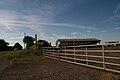
 Shoby House Farm - geograph.org.uk - 3608522.jpg 640 × 480; 59 KB
-

-

-
 Shoby House farmyard - geograph.org.uk - 4455837.jpg 1,280 × 933; 316 KB
-
 Shoby Lane heading north - geograph.org.uk - 3608526.jpg 640 × 480; 73 KB
-
 Shoby Lane into Grimston - geograph.org.uk - 5015744.jpg 640 × 468; 135 KB
-
 Shoby Lane leaving Grimston - geograph.org.uk - 2815261.jpg 4,000 × 3,000; 2.5 MB
-
 Shoby Lane towards Shoby - geograph.org.uk - 5015745.jpg 640 × 462; 99 KB
-
 Shoby Lodge along the A6006 - geograph.org.uk - 3167902.jpg 3,264 × 2,448; 3.07 MB
-
 Shoby Lodge Farm accommodation signs - geograph.org.uk - 5925101.jpg 640 × 569; 117 KB
-
 Shoby Lodge Farm entrance in 2018 - geograph.org.uk - 5925102.jpg 640 × 447; 85 KB


.jpg)


.jpg)
.jpg)


.jpg)


.jpg)


