Category:Großsteingrab Auf Bruneforths Esch
Jump to navigation
Jump to search
| Object location | | View all coordinates using: OpenStreetMap |
|---|
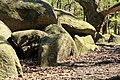
dolmen  | |||||
| Upload media | |||||
| Instance of | |||||
|---|---|---|---|---|---|
| Location | Stavern, Sögel, Emsland, Lower Saxony, Germany | ||||
 | |||||
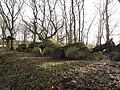
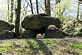
Deutsch: Großsteingrab Auf Bruneforths Esch, Großsteingrab Groß-Stavern 1, Großsteingrab Groß-Stavern I, Sprockhoff-Nr. 846
Media in category "Großsteingrab Auf Bruneforths Esch"
The following 32 files are in this category, out of 32 total.
-
 Bruneforths Esch.JPG 2,592 × 1,944; 2.1 MB
-
 Großsteingrab auf Bruneforths Esch.JPG 3,648 × 2,736; 6.87 MB
-
 NLD Großsteingrab auf Bruneforths Esch 01.jpg 6,000 × 4,000; 4.88 MB
-
 NLD Großsteingrab auf Bruneforths Esch 02.jpg 6,000 × 4,000; 4.42 MB
-
 NLD Großsteingrab auf Bruneforths Esch 03.jpg 6,000 × 4,000; 4.95 MB
-
 NLD Großsteingrab auf Bruneforths Esch 04.jpg 6,000 × 4,000; 3.54 MB
-
 NLD Großsteingrab auf Bruneforths Esch 05.jpg 6,000 × 4,000; 4.57 MB
-
 NLD Großsteingrab auf Bruneforths Esch 06.jpg 6,000 × 4,000; 4.77 MB
-
 Stavern - Berßener Straße + Auf Bruneforths Esch 01 ies.jpg 5,616 × 3,744; 15.96 MB
-
 Stavern - Berßener Straße + Auf Bruneforths Esch 02 ies.jpg 5,616 × 3,743; 32 MB
-
 Stavern - Berßener Straße + Auf Bruneforths Esch 03 ies.jpg 5,616 × 3,744; 17 MB
-
 Stavern - Berßener Straße + Auf Bruneforths Esch 04 ies.jpg 3,744 × 5,616; 16.85 MB
-
 Stavern - Berßener Straße - Auf Bruneforths Esch 01 ies.jpg 5,616 × 3,744; 33.88 MB
-
 Stavern - Berßener Straße - Auf Bruneforths Esch 02 ies.jpg 5,616 × 3,743; 31.69 MB
-
 Stavern - Berßener Straße - Auf Bruneforths Esch 03 ies.jpg 5,616 × 3,744; 28.52 MB
-
 Stavern - Berßener Straße - Auf Bruneforths Esch 04 ies.jpg 5,616 × 3,744; 15.87 MB
-
 Stavern - Berßener Straße - Auf Bruneforths Esch 05 ies.jpg 5,616 × 3,745; 25.47 MB
-
 Stavern - Berßener Straße - Auf Bruneforths Esch 06 ies.jpg 5,616 × 3,744; 31.57 MB
-
 Stavern - Berßener Straße - Auf Bruneforths Esch 07 ies.jpg 5,616 × 3,744; 29.78 MB
-
 Stavern - Berßener Straße - Auf Bruneforths Esch 08 ies.jpg 5,616 × 3,744; 29.97 MB
-
 Stavern - Berßener Straße - Auf Bruneforths Esch 09 ies.jpg 5,616 × 3,744; 33.54 MB
-
 Stavern - Berßener Straße - Auf Bruneforths Esch 10 ies.jpg 5,616 × 3,744; 31.2 MB
-
 Stavern - Berßener Straße - Auf Bruneforths Esch 11 ies.jpg 5,616 × 3,744; 27.32 MB
-
 Stavern - Berßener Straße - Auf Bruneforths Esch 12 ies.jpg 5,616 × 3,744; 28.9 MB
-
 Stavern - Berßener Straße - Auf Bruneforths Esch 13 ies.jpg 3,744 × 5,616; 27.47 MB
-
 Stavern - Berßener Straße - Auf Bruneforths Esch 14 ies.jpg 5,616 × 3,744; 29.88 MB
-
 Stavern - Berßener Straße - Auf Bruneforths Esch 15 ies.jpg 5,616 × 3,744; 26.27 MB
-
 Stavern - Berßener Straße - Auf Bruneforths Esch 16 ies.jpg 5,616 × 3,744; 31.11 MB
-
 Stavern - Berßener Straße - Auf Bruneforths Esch 17 ies.jpg 5,616 × 3,744; 27.79 MB
-
 Stavern - Berßener Straße - Auf Bruneforths Esch 18 ies.jpg 5,616 × 3,744; 27.86 MB
-
 Stavern - Berßener Straße - Auf Bruneforths Esch 19 ies.jpg 5,616 × 3,743; 26.24 MB
-
 Stavern - Berßener Straße - Auf Bruneforths Esch 20 ies.jpg 5,616 × 3,744; 23.67 MB


