Category:Grotte di Catullo (Sirmione)
Jump to navigation
Jump to search
| Object location | | View all coordinates using: OpenStreetMap |
|---|
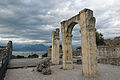
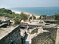
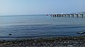
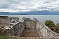
ruins of a Roman villa in Sirmione, Italy  | |||||
| Upload media | |||||
| Instance of | |||||
|---|---|---|---|---|---|
| Culture | |||||
| Location | Sirmione, Province of Brescia, Lombardy, Italy | ||||
| Street address |
| ||||
| Maintained by |
| ||||
| Heritage designation | |||||
| official website | |||||
 | |||||
Subcategories
This category has only the following subcategory.
Media in category "Grotte di Catullo (Sirmione)"
The following 200 files are in this category, out of 209 total.
(previous page) (next page)-
 Ruins of Roman villa Lake Garda.jpg 3,072 × 2,304; 2.63 MB
-
 03I6330002 Sirmione - Grotte di Catullo.jpg 1,280 × 960; 320 KB
-
 03I6330002 Sirmione.jpg 1,280 × 960; 319 KB
-
 1 Sirmione - Area archeologica Grotte di Catullo.jpg 4,160 × 3,120; 3.74 MB
-
 2 Sirmione - Area archeologica Grotte di Catullo.jpg 3,120 × 4,160; 4.84 MB
-
 2017-04-10 04-14 Gardasee 185 Sirmione, Grotte di Catullo (33997295740).jpg 5,866 × 3,816; 16.13 MB
-
 2017-04-10 04-14 Gardasee 186 Sirmione, Grotte di Catullo (34382033275).jpg 5,875 × 3,857; 17.43 MB
-
 2017-04-10 04-14 Gardasee 188 Sirmione, Grotte di Catullo (33571769393).jpg 5,905 × 3,851; 17.72 MB
-
 2017-04-10 04-14 Gardasee 189 Sirmione, Grotte di Catullo (33540139844).jpg 6,000 × 4,000; 17.58 MB
-
 2017-04-10 04-14 Gardasee 190 Sirmione, Grotte di Catullo (34223610552).jpg 4,000 × 6,000; 20.97 MB
-
 2017-04-10 04-14 Gardasee 191 Sirmione, Grotte di Catullo (33571813403).jpg 5,885 × 3,808; 17.06 MB
-
 2017-04-10 04-14 Gardasee 192 Sirmione, Grotte di Catullo (33997367690).jpg 6,000 × 4,000; 19.2 MB
-
 2017-04-10 04-14 Gardasee 193 Sirmione, Grotte di Catullo (33997385170).jpg 4,000 × 6,000; 19.59 MB
-
 2017-04-10 04-14 Gardasee 194 Sirmione, Grotte di Catullo (33571848223).jpg 6,000 × 4,000; 22.14 MB
-
 2017-04-10 04-14 Gardasee 197 Sirmione, Grotte di Catullo (33540243724).jpg 4,000 × 6,000; 20.8 MB
-
 2017-04-10 04-14 Gardasee 199 Sirmione, Grotte di Catullo (33571915293).jpg 4,000 × 6,000; 22.5 MB
-
 2017-04-10 04-14 Gardasee 200 Sirmione, Grotte di Catullo (33571926133).jpg 4,958 × 3,439; 15.24 MB
-
 2017-04-10 04-14 Gardasee 202 Sirmione, Grotte di Catullo (33997495680).jpg 6,000 × 4,000; 19.56 MB
-
 3 Sirmione - Area archeologica Grotte di Catullo.jpg 4,160 × 3,120; 4.73 MB
-
 4 Sirmione - Area archeologica Grotte di Catullo.jpg 4,160 × 3,120; 4.53 MB
-
 5 Sirmione - Area archeologica Grotte di Catullo.jpg 4,160 × 3,120; 4.08 MB
-
 6 Sirmione - Area archeologica Grotte di Catullo.jpg 4,160 × 3,120; 4.33 MB
-
 Accesso al lago.jpg 3,264 × 4,928; 18.45 MB
-
 Albero di ulivo.jpg 1,944 × 1,944; 1.91 MB
-
 Antichità.jpg 4,160 × 2,336; 3.65 MB
-
 Archi - Grotte di Catullo.jpg 2,048 × 1,536; 558 KB
-
 Archi sul lago.jpg 4,922 × 3,281; 10.34 MB
-
 Arco imperiale.jpg 4,928 × 3,264; 7.05 MB
-
 Area archeologica Grotte di Catullo (1).jpg 2,592 × 1,944; 1.07 MB
-
 Area archeologica Grotte di Catullo (2).jpg 1,944 × 2,592; 1.04 MB
-
 Area Archeologica Grotte di Catullo.jpg 2,736 × 3,648; 2.55 MB
-
 Area archeologica Grotte di Catullo.jpg 2,548 × 3,872; 6.52 MB
-
 Built To Last (9644200408).jpg 7,360 × 4,912; 24.84 MB
-
 Calanca daniela-attraverso.jpg 3,543 × 2,362; 3.74 MB
-
 Catullo Sirmione.jpg 2,831 × 1,028; 584 KB
-
 Coast Grotte di Catullo Sirmione 2015-09-05 n1.jpg 4,000 × 2,670; 8.26 MB
-
 Coast Grotte di Catullo Sirmione 2015-09-05 n2.jpg 3,337 × 5,000; 10.74 MB
-
 Coast Grotte di Catullo Sirmione 2015-09-05 n3.jpg 5,000 × 3,337; 13.15 MB
-
 Coastline (9656114919).jpg 7,151 × 4,772; 19.5 MB
-
 Colonnato vista Lago.jpg 3,264 × 2,448; 2.03 MB
-
 Contrafforti Grotte di Catullo Sirmione.jpg 15,884 × 11,758; 117.57 MB
-
 Criptoportico. Lato orientale.jpg 1,599 × 1,274; 504 KB
-
 Fale Lago Garda 39.jpg 2,448 × 3,264; 4.6 MB
-
 Fale Lago Garda 40.jpg 2,448 × 3,264; 4.88 MB
-
 Fale Lago Garda 41.jpg 2,448 × 3,264; 4.3 MB
-
 Fale Lago Garda 43.jpg 2,448 × 3,264; 4.76 MB
-
 Fale Lago Garda 44.jpg 2,448 × 3,264; 2.08 MB
-
 Frigidarium Grotte di Catullo Sirmione 2015-09-05 n2.jpg 4,000 × 2,670; 9.16 MB
-
 Frigidarium Grotte di Catullo Sirmione 2015-09-05.jpg 4,000 × 2,670; 9.22 MB
-

-
 Going Down (9655855561).jpg 4,912 × 7,360; 23.03 MB
-
 Gro123.jpg 1,280 × 590; 177 KB
-
 Grote di Catullo.jpg 3,558 × 2,628; 6.1 MB
-
 Grotte di Catullo (52115228700).jpg 3,200 × 1,800; 2.04 MB
-
 Grotte di Catullo - area archeologica.jpg 2,048 × 1,232; 1.7 MB
-
 Grotte di Catullo - Sirmione.jpg 3,872 × 2,592; 9.59 MB
-
 Grotte di catullo 01.JPG 1,600 × 1,200; 951 KB
-
 Grotte di Catullo 01.jpg 2,272 × 1,704; 364 KB
-
 Grotte di catullo 02.JPG 1,600 × 1,200; 822 KB
-
 Grotte di Catullo 02.jpg 2,272 × 1,704; 409 KB
-
 Grotte di catullo 03.JPG 1,600 × 1,200; 996 KB
-
 Grotte di catullo 04.JPG 1,600 × 1,200; 995 KB
-
 Grotte di catullo 05.JPG 1,600 × 1,200; 990 KB
-
 Grotte di catullo 06.JPG 1,600 × 1,200; 1.71 MB
-
 Grotte di catullo 07.JPG 1,600 × 1,200; 993 KB
-
 Grotte di catullo 08.JPG 1,600 × 1,200; 1,006 KB
-
 Grotte di catullo 09.JPG 1,200 × 1,600; 978 KB
-
 Grotte di Catullo 1 (9629212505).jpg 4,863 × 7,287; 27.34 MB
-
 Grotte di Catullo 10 (9659169822).jpg 7,360 × 4,912; 27.12 MB
-
 Grotte di catullo 10.JPG 1,200 × 1,600; 996 KB
-
 Grotte di catullo 11.JPG 1,200 × 1,600; 983 KB
-
 Grotte di catullo 13.JPG 1,600 × 1,200; 911 KB
-
 Grotte di catullo 14.JPG 1,600 × 1,200; 893 KB
-
 Grotte di catullo 15.JPG 1,200 × 1,600; 904 KB
-
 Grotte di catullo 16 Opera spicata.JPG 1,600 × 1,200; 807 KB
-
 Grotte di catullo 17 Opera spicata.JPG 1,600 × 1,200; 902 KB
-
 Grotte di catullo 18 Opera spicata.JPG 1,600 × 1,200; 810 KB
-
 Grotte di catullo 19 Opera spicata.JPG 1,600 × 1,200; 776 KB
-
 Grotte di Catullo 2 (9629276181).jpg 7,360 × 4,912; 27.78 MB
-
 Grotte di Catullo 3 (9629339447).jpg 7,360 × 4,912; 29.92 MB
-
 Grotte di Catullo 4 (9632954926).jpg 7,360 × 4,912; 24.36 MB
-
 Grotte di Catullo 5 (9633012978).jpg 7,360 × 4,912; 33.24 MB
-
 Grotte di Catullo 6 (9629829345).jpg 7,360 × 4,912; 28.91 MB
-
 Grotte di Catullo 7 (9643996686).jpg 7,360 × 4,912; 32.44 MB
-
 Grotte di Catullo 8 (9644045116).jpg 4,739 × 7,101; 24.9 MB
-
 Grotte di Catullo 9 (9640862331).jpg 4,912 × 7,360; 27.63 MB
-
 Grotte di Catullo a Sirmione.jpg 1,600 × 1,200; 1.11 MB
-
 Grotte di Catullo A Sirmione.jpg 17,590 × 6,730; 74.52 MB
-
 Grotte di Catullo B Sirmione.jpg 20,000 × 5,145; 82.09 MB
-
 Grotte di Catullo banner.jpg 3,845 × 549; 1.63 MB
-
 Grotte di Catullo C Sirmione.jpg 8,957 × 8,159; 55.84 MB
-
 Grotte di Catullo D Sirmione.jpg 15,213 × 14,124; 142.85 MB
-
 Grotte di Catullo e Lago di Garda.jpg 2,048 × 1,536; 529 KB
-
 Grotte di Catullo E Sirmione.jpg 14,437 × 13,684; 123.49 MB
-
 Grotte di Catullo F Sirmione.jpg 11,821 × 12,866; 82.14 MB
-
 Grotte di Catullo from lake.jpg 3,618 × 2,712; 6.76 MB
-
 Grotte di Catullo G Sirmione.jpg 12,072 × 13,067; 84.9 MB
-
 Grotte di Catullo H Sirmione.jpg 13,395 × 6,990; 55.61 MB
-
 Grotte di Catullo i Sirmione.jpg 16,266 × 8,158; 106.06 MB
-
 Grotte di Catullo interno, Sirmione.jpg 1,600 × 1,200; 1.15 MB
-
 Grotte di Catullo J Sirmione.jpg 15,514 × 5,915; 78.21 MB
-
 Grotte di Catullo K Sirmione.jpg 18,539 × 6,125; 83.55 MB
-
 Grotte di Catullo L Sirmione.jpg 11,000 × 6,995; 60.31 MB
-
 Grotte di Catullo M Sirmione.jpg 14,932 × 5,825; 60.18 MB
-
 Grotte di Catullo N Sirmione.jpg 12,218 × 8,576; 73.29 MB
-
 Grotte di Catullo O Sirmione.jpg 18,276 × 8,314; 111.05 MB
-
 Grotte di Catullo P Sirmione.jpg 9,633 × 9,107; 69.71 MB
-
 Grotte di Catullo Q Sirmione.jpg 11,000 × 5,303; 58.31 MB
-
 Grotte di Catullo R Sirmione.jpg 12,396 × 5,940; 62.47 MB
-
 Grotte di Catullo S Sirmione.jpg 10,098 × 5,263; 44.67 MB
-
 Grotte di Catullo Sirmione.JPG 1,944 × 2,592; 2.06 MB
-
 Grotte di Catullo T Sirmione.jpg 15,604 × 5,769; 74.9 MB
-
 Grotte di Catullo z Sirmione.jpg 18,467 × 8,903; 119.97 MB
-
 Grotte di Catullo, arco e viale.jpg 4,000 × 6,000; 5.38 MB
-
 Grotte di Catullo, arco e vista.jpg 6,000 × 4,000; 6.21 MB
-
 Grotte di Catullo, arco.jpg 6,000 × 4,000; 9.97 MB
-
 Grotte di Catullo, colonne.jpg 6,000 × 4,000; 4.92 MB
-
 Grotte di Catullo, Sirmione.jpg 1,564 × 1,173; 322 KB
-
 Grotte di Catullo.JPG 2,592 × 1,944; 1.87 MB
-
 Grotte di Catullo.jpg 500 × 375; 63 KB
-
 Grotte e lago.jpg 2,048 × 1,536; 549 KB
-
 GrottediCatullo.JPG 2,048 × 1,536; 1.42 MB
-
 Grotto of Catullus from Lake Garda 2012 II.JPG 3,250 × 2,430; 4.06 MB
-
 Grotto of Catullus from Lake Garda 2012.JPG 3,230 × 2,402; 2.95 MB
-
 Grottoes of Catullus - Grotte di Catullo (5364).jpg 5,456 × 3,632; 10.93 MB
-
 Grottoes of Catullus - Grotte di Catullo (5370).jpg 5,456 × 3,632; 7.86 MB
-
 Grottoes of Catullus - Grotte di Catullo (5376).jpg 3,632 × 5,456; 9.03 MB
-
 Grottoes of Catullus - Grotte di Catullo (5380).jpg 5,455 × 3,584; 9.08 MB
-
 Grottoes of Catullus - Grotte di Catullo, Cryptoporticus 01.jpg 5,456 × 3,632; 9.45 MB
-
 Grottoes of Catullus - Grotte di Catullo, Cryptoporticus 02.jpg 5,456 × 3,632; 10.31 MB
-
 Il lago visto dalle Grotte di Catullo.jpg 4,729 × 3,133; 1.62 MB
-
 Imagegrottecatullo.jpg 2,048 × 1,536; 1.15 MB
-
 L00 121 »Grotten des Catull«.jpg 6,562 × 4,375; 7.59 MB
-
 L00 122 »Grotten des Catull«.jpg 6,471 × 4,241; 6.63 MB
-
 Lago di Garda,Sirmione, Grotte di Catullo.jpg 4,288 × 2,848; 6.65 MB
-
 Lake Garda Grotte di Catullo 1.jpg 1,024 × 685; 673 KB
-
 Le Grotte dal Lago.jpg 4,928 × 3,264; 19.25 MB
-
 Le Grotte di Catullo sul lago.jpg 3,850 × 2,166; 4.65 MB
-
 Lido delle Bionde from Grotte di Catullo Sirmione 2015-09-05 n2.jpg 5,000 × 3,337; 10.01 MB
-
 Long corridor Grotte di Catullo Sirmione 2015-09-05.jpg 5,000 × 3,337; 15.51 MB
-
 Massicciata.jpg 4,928 × 3,264; 17.62 MB
-
 Mura medievali dettaglio Grotte di Catullo Sirmione.jpg 13,292 × 10,835; 106.22 MB
-
 Mura medievali Grotte di Catullo Sirmione.jpg 9,000 × 5,965; 43.88 MB
-
 Olive grove Grotte di Catullo Sirmione 2015-09-05 n1.jpg 4,000 × 2,666; 11.31 MB
-
 Olive Tree (9659277178).jpg 4,912 × 7,360; 35.39 MB
-
 Panorama dalle Grotte di Catullo, Sirmione.jpg 1,600 × 1,200; 1.03 MB
-
 Paolo Monti - Serie fotografica - BEIC 6364206.jpg 1,121 × 1,180; 1.9 MB
-
 Particolare - Grotte di Catullo.jpg 3,456 × 2,592; 2.99 MB
-
 Penisola di Sirmione con le grotte.jpg 1,024 × 576; 79 KB
-
 Piscina Grotte di Catullo Sirmione 2015-09-05.jpg 4,000 × 2,670; 10.87 MB
-
 Portale ad arco.jpg 1,390 × 1,600; 245 KB
-
 Portico Grotte di Catullo Sirmione 2015-09-05 n1.jpg 4,000 × 2,670; 10.82 MB
-
 Portico Grotte di Catullo Sirmione 2015-09-05 n2.jpg 4,000 × 2,670; 9.65 MB
-
 Portico Grotte di Catullo Sirmione 2015-09-05 n3.jpg 5,000 × 3,337; 12.29 MB
-
 Portico Grotte di Catullo Sirmione 2015-09-05 n4.jpg 5,000 × 3,337; 16.69 MB
-
 Portico Grotte di Catullo Sirmione 2015-09-05.jpg 5,000 × 3,337; 13.82 MB
-
 Rekonstruierte Gesamtansicht des Palastgartens von Westen.jpg 4,096 × 2,160; 8.22 MB
-
 Rekonstruierte Gesamtansicht von Norden.jpg 4,096 × 2,160; 7.69 MB
-
 Rekonstruierte Gesamtansicht von Osten.jpg 4,096 × 2,160; 5.61 MB
-
 Rekonstruierte Gesamtansicht von Westen.jpg 4,096 × 2,160; 7.02 MB
-
 Rekonstruierte Innenansicht der Westhalle.jpg 4,096 × 2,160; 5.18 MB
-
 Rekonstruktierte Gesamtansicht von Süden.jpg 4,096 × 2,160; 7.14 MB
-
 Rekonstruktion des Palastgartens.jpg 4,096 × 2,160; 7.54 MB
-
 Rekonstruktion von Osthalle und Ostterrasse.jpg 4,096 × 2,160; 6.7 MB
-
 Scorcio d'acqua.jpg 2,336 × 4,160; 4.34 MB
-
 Sirmione - Grotte di Catullo - 202109172000 2.jpg 2,560 × 3,412; 4.3 MB
-
 Sirmione - Grotte di Catullo - 202109172000 3.jpg 2,736 × 3,648; 4.36 MB
-
 Sirmione - Grotte di Catullo - 202109172000.jpg 2,736 × 3,648; 4.15 MB
-
 Sirmione - Grotte di Catullo - 202109172005 2.jpg 2,736 × 3,648; 3.67 MB
-
 Sirmione - Grotte di Catullo - 202109172005 3.jpg 2,736 × 3,648; 3.73 MB
-
 Sirmione - Grotte di Catullo.jpg 2,592 × 3,888; 1.43 MB
-
 Sirmione - Le grotte di Catullo.jpg 3,872 × 2,592; 9.95 MB
-
 Sirmione grotte di catullo 1.jpg 640 × 480; 350 KB
-
 Sirmione grotte di catullo 2.jpg 640 × 480; 360 KB
-
 Sirmione Grotte di Catullo Blick auf den Lago di Garda 1.jpg 4,523 × 2,857; 6.99 MB
-
 Sirmione Grotte di Catullo Blick auf den Lago di Garda 2.jpg 4,573 × 3,158; 7.33 MB
-
 Sirmione Grotte di Catullo Blick auf den Lago di Garda 3.jpg 4,519 × 2,789; 7.15 MB
-
 Sirmione grotte di catullo olive.jpg 480 × 640; 367 KB
-
 Sirmione Villa 001.JPG 3,348 × 2,408; 2.06 MB
-
 Sirmione Villa 002.JPG 3,452 × 2,283; 2.84 MB
-
 Sirmione, Grottoes of Catullus, lizard.jpg 4,272 × 2,848; 3.92 MB
-
 Sirmione, Grottoes of Catullus, olive tree.jpg 4,272 × 2,848; 5.59 MB
-
 Sirmione, Grottoes of Catullus, olive trees.jpg 4,272 × 2,848; 4.5 MB
-
 Sirmione, Grottoes of Catullus, view to the church San Pietro in Mavino.jpg 4,272 × 2,848; 3.5 MB
-
 Sirmione, Grottoes of Catullus, view to the Monte Pizzocolo.jpg 4,192 × 2,787; 4.61 MB
-
 Sirmione, Grottoes of Catullus, view to the Rocca di Manerba and Toscolano Maderno.jpg 4,265 × 2,771; 4.02 MB
-
 Sirmione, Grottoes of Catullus-1.jpg 4,272 × 2,848; 5.32 MB
-
 Sirmione, Grottoes of Catullus-2.jpg 4,045 × 2,780; 3.95 MB
-
 Sirmione, Grottoes of Catullus-3.jpg 4,231 × 2,785; 4.99 MB
-
 Sirmione, Grottoes of Catullus-4.jpg 4,272 × 2,848; 4.95 MB
-
 Sirmione, Grottoes of Catullus-5.jpg 4,272 × 2,848; 5.96 MB
-
 Sirmione, Grottoes of Catullus-6.jpg 2,343 × 4,317; 5.3 MB
-
 Sirmione, Grottoes of Catullus-7.jpg 4,272 × 2,848; 6.15 MB
-
 Sirmione, Province of Brescia, Italy - panoramio.jpg 3,456 × 2,592; 3.95 MB
-
 Sirmione-Grotte di Catullo-B&N.jpg 680 × 1,024; 460 KB
-
 Sirmione-Grotte di Catullo.jpg 1,365 × 2,048; 804 KB
-
 Spiaggia di colombare.jpg 3,264 × 1,836; 2.48 MB
-
 Substructions Grotte di Catullo Sirmione 2015-09-05 n1.jpg 5,000 × 3,337; 14.78 MB
-
 Substructions Grotte di Catullo Sirmione 2015-09-05 n2.jpg 5,000 × 3,336; 14.22 MB
-
 Substructions Grotte di Catullo Sirmione 2015-09-05 n3.jpg 5,000 × 3,337; 15.16 MB


.jpg)
.jpg)
.jpg)
.jpg)
.jpg)
.jpg)
.jpg)
.jpg)
.jpg)
.jpg)
.jpg)
.jpg)
.jpg)


.jpg)
.jpg)


.jpg)


.jpg)


.jpg)


.jpg)


.jpg)
.jpg)


.jpg)
.jpg)
.jpg)
.jpg)
.jpg)
.jpg)
.jpg)
.jpg)


.jpg)
.jpg)
.jpg)
.jpg)


.jpg)


&uselang=%E2%A7%BClang%E2%A7%BD&filefrom=Substructions+Grotte+di+Catullo+Sirmione+2015-09-05+n4.jpg#mw-category-media)