Category:Guarlford
Aller à la navigation
Aller à la recherche
village britannique  | |||||
| Téléverser des médias | |||||
| Nature de l’élément | |||||
|---|---|---|---|---|---|
| Lieu | Malvern Hills, Worcestershire, Midlands de l'Ouest, Angleterre | ||||
 | |||||
Sous-catégories
Cette catégorie comprend 2 sous-catégories, dont les 2 ci-dessous.
G
- Guarlford war memorial (5 F)
Média dans la catégorie « Guarlford »
Cette catégorie comprend 201 fichiers, dont les 200 ci-dessous.
(page précédente) (page suivante)-
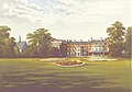 CS p5.388 - Rhydd Court, Worcestershire - Morris's County Seats, 1880 (cropped).jpg 2 297 × 1 614 ; 934 kio
-
 CS p5.388 - Rhydd Court, Worcestershire - Morris's County Seats, 1880.jpg 2 880 × 2 074 ; 1,07 Mio
-
 A.J.Gammond, Clevelode Road, Guarlford - geograph.org.uk - 892901.jpg 640 × 427 ; 261 kio
-
 Across the field to Grove House Farm and the Malverns - geograph.org.uk - 6322001.jpg 1 600 × 1 200 ; 303 kio
-
 Agricultural workers' cottages, Hall Green - geograph.org.uk - 889602.jpg 640 × 427 ; 272 kio
-
 Arable land near Whiteacres Farm - geograph.org.uk - 1079015.jpg 640 × 426 ; 111 kio
-
 Autumnal grasses beside the B4211 - geograph.org.uk - 4655472.jpg 1 600 × 1 200 ; 567 kio
-
 B4211 east of Guarlford - geograph.org.uk - 2205414.jpg 1 024 × 768 ; 139 kio
-
 B4211 Junction With B4424 Rhydd Green - geograph.org.uk - 4919052.jpg 640 × 480 ; 71 kio
-
 B4211 Rhydd Green - geograph.org.uk - 4919050.jpg 640 × 468 ; 43 kio
-
 B4211 Turning on Right to Priestfield - geograph.org.uk - 4919048.jpg 640 × 469 ; 48 kio
-
 B4424 at Rydd - geograph.org.uk - 2527477.jpg 640 × 480 ; 132 kio
-
 Bamford Close, Guarlford - geograph.org.uk - 5171815.jpg 1 024 × 768 ; 282 kio
-
 Beans and burdock, Guarlford - geograph.org.uk - 892742.jpg 640 × 427 ; 309 kio
-
 Bench mark on milestone - geograph.org.uk - 4039150.jpg 2 560 × 1 920 ; 1,06 Mio
-

-

-
 Caravan park beside the River Severn - geograph.org.uk - 4436616.jpg 1 024 × 768 ; 271 kio
-
 Caravans reflected in the River Severn - geograph.org.uk - 4343770.jpg 800 × 531 ; 142 kio
-
 Caravans reflected in the River Severn - geograph.org.uk - 4343778.jpg 800 × 531 ; 146 kio
-
 Caravens reflected in the River Severn - geograph.org.uk - 4343774.jpg 531 × 800 ; 136 kio
-
 Cleared land beside the former Plough and Harrow Inn - geograph.org.uk - 6054634.jpg 1 024 × 768 ; 250 kio
-
 Country road past Heriot's Farm - geograph.org.uk - 1079025.jpg 640 × 426 ; 75 kio
-
 Cow pasture and pond near New House Farm - geograph.org.uk - 889824.jpg 640 × 427 ; 259 kio
-
 Cow pasture near New House Farm - geograph.org.uk - 889810.jpg 640 × 427 ; 274 kio
-
 Disused building in field next to Jasmin Cottage - geograph.org.uk - 6322833.jpg 1 600 × 1 200 ; 425 kio
-
 Disused malthouse, Guarlford - geograph.org.uk - 1566705.jpg 480 × 640 ; 135 kio
-
 Dripshill at dawn - geograph.org.uk - 3173718.jpg 640 × 381 ; 167 kio
-
 Dripshill Wood viewed from the north - geograph.org.uk - 997559.jpg 640 × 426 ; 129 kio
-
 Eight bar gate, Guarlford - geograph.org.uk - 892761.jpg 640 × 427 ; 299 kio
-
 Entrance to Riverside Caravan Park - geograph.org.uk - 4866657.jpg 4 483 × 2 723 ; 2,13 Mio
-
 Entrance to Whiteacres - geograph.org.uk - 898332.jpg 640 × 427 ; 294 kio
-
 Estate cottages - geograph.org.uk - 889740.jpg 640 × 427 ; 253 kio
-
 Falconers Farm - geograph.org.uk - 1076569.jpg 640 × 426 ; 91 kio
-
 Field by the white house near Rhydd - geograph.org.uk - 2335156.jpg 640 × 480 ; 51 kio
-
 Flasher's Wood - geograph.org.uk - 633178.jpg 640 × 480 ; 67 kio
-
 Footpath beside Whiteacres Brook - geograph.org.uk - 5078347.jpg 1 024 × 768 ; 311 kio
-
 Former Garage, Petrol Station at Fowler's Farm - geograph.org.uk - 5364901.jpg 2 425 × 1 219 ; 945 kio
-
 Frosty morning, Portock's End - geograph.org.uk - 1076570.jpg 640 × 426 ; 84 kio
-
 Frozen field - geograph.org.uk - 1076568.jpg 640 × 426 ; 117 kio
-
 Frozen land, near Clevelode - geograph.org.uk - 1079021.jpg 640 × 426 ; 87 kio
-
 Grange Farm Nurseries - geograph.org.uk - 2967712.jpg 1 024 × 577 ; 319 kio
-
 Greenfields, Guarlford - geograph.org.uk - 889844.jpg 640 × 427 ; 274 kio
-
 Grove House Farm (1) - geograph.org.uk - 6322799.jpg 1 600 × 1 200 ; 356 kio
-
 Grove House Farm (2) - geograph.org.uk - 6322804.jpg 1 600 × 1 200 ; 253 kio
-
 Grove House Farm - geograph.org.uk - 889768.jpg 640 × 412 ; 250 kio
-
 Grove House Farm - geograph.org.uk - 889775.jpg 640 × 392 ; 228 kio
-
 Guarlford - Bamford Close - geograph.org.uk - 833654.jpg 640 × 480 ; 70 kio
-
 Guarlford - isolated houses - geograph.org.uk - 833676.jpg 640 × 480 ; 72 kio
-
 Guarlford - shady phone box - geograph.org.uk - 833689.jpg 640 × 480 ; 104 kio
-
 Guarlford - the main road junction - geograph.org.uk - 833681.jpg 640 × 480 ; 73 kio
-
 Guarlford Road - geograph.org.uk - 6255159.jpg 1 892 × 1 236 ; 1,22 Mio
-
 Guarlford Road - geograph.org.uk - 6255160.jpg 1 832 × 1 130 ; 1,29 Mio
-

-
 Guarlford Road on the edge of the village - geograph.org.uk - 6322809.jpg 1 600 × 1 200 ; 349 kio
-
 Guarlford Road, Guarlford, Worcestershire - geograph.org.uk - 4667269.jpg 1 600 × 1 200 ; 536 kio
-
 Guarlford Village Hall - geograph.org.uk - 1566696.jpg 640 × 480 ; 112 kio
-
 Guarlford Village Hall - geograph.org.uk - 637602.jpg 640 × 469 ; 88 kio
-
 Guarlford Village Sign on the B4211 - geograph.org.uk - 4919037.jpg 640 × 466 ; 63 kio
-
 Guarlford Village Turning on the Right - geograph.org.uk - 4919039.jpg 640 × 480 ; 103 kio
-
 Hay bales beside the B4211 - geograph.org.uk - 1004153.jpg 640 × 426 ; 90 kio
-
 Hay bales in a field - geograph.org.uk - 5171911.jpg 1 024 × 768 ; 295 kio
-
 Hayler's End Incinerator - geograph.org.uk - 662359.jpg 640 × 426 ; 88 kio
-
 Heriots Farm, Clevelode Lane, Guarlford - geograph.org.uk - 6321848.jpg 1 600 × 1 200 ; 301 kio
-
 Herriots Farm, Guarlford - geograph.org.uk - 892747.jpg 640 × 427 ; 267 kio
-
 Hilltop windmill site^ - geograph.org.uk - 898705.jpg 640 × 427 ; 258 kio
-
 Honeypot Farm - near Rhydd - geograph.org.uk - 833508.jpg 640 × 480 ; 129 kio
-
 House at Portock's End - geograph.org.uk - 4866649.jpg 4 085 × 2 451 ; 1,58 Mio
-
 Houses at Clevelode - geograph.org.uk - 4344487.jpg 800 × 531 ; 101 kio
-
 Houses at the Rhydd - geograph.org.uk - 4343749.jpg 800 × 531 ; 170 kio
-
 Jasmin Cottage from the field side - geograph.org.uk - 6322830.jpg 1 600 × 1 200 ; 341 kio
-
 Little Herriots, Guarlford - geograph.org.uk - 892832.jpg 640 × 427 ; 249 kio
-
 Long, narrow field, Guarlford - geograph.org.uk - 892768.jpg 640 × 418 ; 266 kio
-
 Looking down Wood Street - geograph.org.uk - 852963.jpg 640 × 480 ; 65 kio
-
 Looking over Willows End to the cloud covered Malverns - geograph.org.uk - 6321840.jpg 1 600 × 1 200 ; 364 kio
-
 Lost the peloton - geograph.org.uk - 4625954.jpg 1 600 × 1 200 ; 270 kio
-
 Men at work, Guarlford - geograph.org.uk - 1566710.jpg 640 × 480 ; 156 kio
-
 Minor road on the northern edge of Guarlford - geograph.org.uk - 2335161.jpg 640 × 480 ; 74 kio
-
 Mushrooms on the edge of South Wood, Malvern - geograph.org.uk - 6321866.jpg 1 600 × 1 200 ; 580 kio
-
 Narrow pasture - geograph.org.uk - 889793.jpg 640 × 427 ; 277 kio
-
 New buildings, Clevelode Road, Guarlford - geograph.org.uk - 892906.jpg 640 × 410 ; 280 kio
-
 New House Farm (1) - geograph.org.uk - 6322814.jpg 1 600 × 1 200 ; 440 kio
-
 New House Farm (2) - geograph.org.uk - 6322821.jpg 1 600 × 1 200 ; 409 kio
-
 New House Farm - geograph.org.uk - 889819.jpg 640 × 399 ; 245 kio
-
 New House Farm and Pond Guarlford - geograph.org.uk - 4919041.jpg 640 × 480 ; 87 kio
-
 New House Farm Pond Guarlford - geograph.org.uk - 4919042.jpg 640 × 480 ; 104 kio
-
 Oak trees near Bills Hill - geograph.org.uk - 1076577.jpg 640 × 426 ; 103 kio
-
 Old orchard, Guarlford - geograph.org.uk - 892775.jpg 640 × 427 ; 270 kio
-
 Pasture, Guarlford - geograph.org.uk - 889840.jpg 640 × 420 ; 251 kio
-
 Path through wheatfield - geograph.org.uk - 894192.jpg 640 × 427 ; 288 kio
-
 Path through wheatfield near Whiteacres Brook - geograph.org.uk - 898298.jpg 640 × 427 ; 269 kio
-
 Path to Whitacres Farm - geograph.org.uk - 898540.jpg 640 × 427 ; 276 kio
-
 Pear tree near Grove House Farm - geograph.org.uk - 889746.jpg 640 × 390 ; 255 kio
-
 Pears in mid July - geograph.org.uk - 889748.jpg 640 × 458 ; 264 kio
-
 Penny Close, Guarlford.jpg 640 × 480 ; 76 kio
-
 Plough and Harrow pub, near Guarlford - geograph.org.uk - 833520.jpg 640 × 480 ; 65 kio
-
 Ploughed field near Whiteacres Farm - geograph.org.uk - 898325.jpg 640 × 372 ; 212 kio
-
 Ploughed field near Whiteacres Farm - geograph.org.uk - 898552.jpg 640 × 427 ; 251 kio
-
 Ploughed field near Whiteacres Farm - geograph.org.uk - 997103.jpg 640 × 426 ; 106 kio
-
 Ploughed field, near Guarlford - geograph.org.uk - 1149948.jpg 640 × 426 ; 113 kio
-
 Pond beside the Plough and Harrow - geograph.org.uk - 1004144.jpg 640 × 426 ; 120 kio
-
 Priestfield road junction - geograph.org.uk - 833512.jpg 640 × 480 ; 77 kio
-

-
 Pylons cross the road near White House Farm - geograph.org.uk - 2335164.jpg 640 × 480 ; 43 kio
-
 Rhydd Green - Bramley Cottage - geograph.org.uk - 833564.jpg 640 × 480 ; 110 kio
-
 Rhydd Green - Hanley Swan road - geograph.org.uk - 833561.jpg 640 × 480 ; 105 kio
-
 River Severn and Clevelode Caravan Park - geograph.org.uk - 4343777.jpg 800 × 531 ; 110 kio
-
 Riverside caravan park, Clevelode - geograph.org.uk - 4343766.jpg 1 024 × 680 ; 283 kio
-
 Road junction at Rhydd - geograph.org.uk - 3552701.jpg 680 × 1 024 ; 230 kio
-
 Road junction at Rhydd - geograph.org.uk - 3552718.jpg 1 024 × 680 ; 219 kio
-
 Road narrows approaching the B4424 - geograph.org.uk - 2335168.jpg 640 × 480 ; 91 kio
-
 Road straightening near Whiteacres Farm - geograph.org.uk - 898318.jpg 640 × 427 ; 249 kio
-
 Road to Sherrard's Green - geograph.org.uk - 1566654.jpg 640 × 455 ; 89 kio
-

-
 Sherrards Green Road - geograph.org.uk - 836041.jpg 640 × 480 ; 85 kio
-
 Sherrards Green, 1 - geograph.org.uk - 4539104.jpg 800 × 451 ; 201 kio
-
 Sherrards Green, 2 - geograph.org.uk - 4539108.jpg 800 × 451 ; 209 kio
-
 Sherrards Green, 3 - geograph.org.uk - 4539111.jpg 800 × 451 ; 191 kio
-
 Short back and sides, hedge cut - geograph.org.uk - 4655525.jpg 1 600 × 1 200 ; 537 kio
-
 Small waterfall, Whiteacres Brook, Guarlford - geograph.org.uk - 892726.jpg 640 × 427 ; 356 kio
-
 Snowy B4211 at Guarlford - geograph.org.uk - 2205412.jpg 1 024 × 768 ; 129 kio
-
 Stile, Wood Street - geograph.org.uk - 1055378.jpg 640 × 437 ; 335 kio
-
 Strange derelict machinery at Fowler's Farm - geograph.org.uk - 4655876.jpg 1 600 × 1 200 ; 522 kio
-
 Stubble field near Whiteacres Farm - geograph.org.uk - 1079009.jpg 640 × 426 ; 110 kio
-
 The "Guarlford Straight" - geograph.org.uk - 889484.jpg 640 × 427 ; 284 kio
-
 The "Guarlford Straight", Malvern - geograph.org.uk - 889486.jpg 640 × 430 ; 285 kio
-
 The B4211 Rhydd Green - geograph.org.uk - 6394173.jpg 1 469 × 871 ; 450 kio
-
 The B4211, Guarlford - geograph.org.uk - 6394172.jpg 1 452 × 948 ; 514 kio
-
 The Herriots, Guarlford - geograph.org.uk - 892753.jpg 640 × 412 ; 257 kio
-

-
 The Plough and Harrow, near Guarlford - geograph.org.uk - 1004137.jpg 640 × 426 ; 72 kio
-
 Track to the pylon - geograph.org.uk - 836034.jpg 480 × 640 ; 72 kio
-
 Track to Woodbridge Farm, Guarlford - geograph.org.uk - 840312.jpg 640 × 480 ; 101 kio
-
 Tree in a ploughed field - geograph.org.uk - 5075856.jpg 1 024 × 768 ; 281 kio
-
 Victorian letterbox, Guarlford - geograph.org.uk - 5172528.jpg 450 × 800 ; 116 kio
-

-
 View of Dripshill from Chance Lane - geograph.org.uk - 852842.jpg 640 × 480 ; 43 kio
-
 View to the Clevelode Road - geograph.org.uk - 898547.jpg 640 × 427 ; 241 kio
-
 View to Woodbridge Farm - geograph.org.uk - 5697997.jpg 1 024 × 680 ; 253 kio
-
 View to Woodbridge Farm - geograph.org.uk - 5698000.jpg 800 × 531 ; 91 kio
-
 Water trough in pasture - geograph.org.uk - 889838.jpg 640 × 407 ; 258 kio
-
 Wet field at Guarlford - geograph.org.uk - 637589.jpg 640 × 480 ; 96 kio
-
 Wheat field and the Whiteacres valley, Guarlford - geograph.org.uk - 896643.jpg 640 × 427 ; 262 kio
-
 Wheat field, Guarlford - geograph.org.uk - 892921.jpg 640 × 421 ; 247 kio
-
 Wheat field, Guarlford - geograph.org.uk - 892924.jpg 640 × 427 ; 281 kio
-
 Whiteacres Farm - geograph.org.uk - 4866652.jpg 3 859 × 2 135 ; 1,2 Mio
-
 Whiteacres Farm - geograph.org.uk - 631887.jpg 640 × 476 ; 106 kio
-
 Whiteacres Farm - geograph.org.uk - 633393.jpg 640 × 480 ; 123 kio
-
 Whiteacres Farm - geograph.org.uk - 633395.jpg 640 × 480 ; 109 kio
-
 Whiteacres Farm realignment (2) - geograph.org.uk - 839146.jpg 640 × 480 ; 106 kio
-
 Whiteacres Farm, Guarlford - geograph.org.uk - 894184.jpg 640 × 427 ; 282 kio
-
 Winter crop near South Wood with the Malverns in the background - geograph.org.uk - 6321904.jpg 1 600 × 1 200 ; 356 kio
-
 Winter trees at Clevelode - geograph.org.uk - 4343781.jpg 800 × 531 ; 178 kio
-
 Wood Street - geograph.org.uk - 1553889.jpg 640 × 427 ; 341 kio
-
 Woodbridge Farm - geograph.org.uk - 833664.jpg 640 × 480 ; 97 kio
-
 Woodbridge Farm lane - geograph.org.uk - 833661.jpg 640 × 480 ; 123 kio
-
 Alternative to stiles - geograph.org.uk - 1159692.jpg 640 × 427 ; 285 kio
-
 Approaching Rhydd junction - geograph.org.uk - 1005083.jpg 640 × 426 ; 88 kio
-
 Blackmore Caravan Club Site - geograph.org.uk - 676833.jpg 640 × 480 ; 58 kio
-
 Blackmore Guide Campsite - geograph.org.uk - 847360.jpg 640 × 480 ; 45 kio
-
 Blackmore lodge - geograph.org.uk - 662367.jpg 640 × 426 ; 91 kio
-
 Bluebell Pub - geograph.org.uk - 700892.jpg 640 × 403 ; 235 kio
-
 Boats at Woodbridge Farm - geograph.org.uk - 637727.jpg 640 × 480 ; 114 kio
-
 Dripshill Farm - geograph.org.uk - 374449.jpg 640 × 426 ; 110 kio
-
 Fallen tree at Blackmore End - geograph.org.uk - 637419.jpg 640 × 480 ; 85 kio
-
 Footpath near Stable Farm - geograph.org.uk - 637754.jpg 640 × 480 ; 99 kio
-
 Footpath to Guarlford - geograph.org.uk - 637585.jpg 640 × 480 ; 94 kio
-
 Footpath to Guarlford - geograph.org.uk - 637586.jpg 640 × 480 ; 88 kio
-
 Footpath to Heriots Farm - geograph.org.uk - 632155.jpg 640 × 480 ; 62 kio
-
 Footpath to Malvern - geograph.org.uk - 637745.jpg 640 × 480 ; 80 kio
-
 Gateway to Guarlford - geograph.org.uk - 637592.jpg 640 × 480 ; 139 kio
-
 Grange Farm Nursery pond - geograph.org.uk - 637614.jpg 640 × 480 ; 128 kio
-
 Guide Camp 2007 - geograph.org.uk - 475530.jpg 640 × 427 ; 245 kio
-
 Harvesting tracks at Guarlford - geograph.org.uk - 633159.jpg 640 × 480 ; 77 kio
-
 Heriots Farm - geograph.org.uk - 632167.jpg 640 × 480 ; 96 kio
-
 Horse gallop at Ox Hill - geograph.org.uk - 637752.jpg 640 × 480 ; 93 kio
-
 Lane at Heriots Farm - geograph.org.uk - 632173.jpg 640 × 480 ; 71 kio
-
 Lane near Guarlford - geograph.org.uk - 637719.jpg 640 × 480 ; 117 kio
-
 Lane to Broadacres Farm - geograph.org.uk - 637406.jpg 640 × 480 ; 84 kio
-
 Lane to Guarlford - geograph.org.uk - 637619.jpg 640 × 480 ; 90 kio
-
 Lane to Guarlford - geograph.org.uk - 637621.jpg 640 × 480 ; 95 kio
-
 Lone tree near Bills Hill - geograph.org.uk - 633165.jpg 640 × 480 ; 96 kio
-
 Malthouse at Guarlford - geograph.org.uk - 637609.jpg 640 × 476 ; 37 kio
-
 Oak tree near Blackmore End - geograph.org.uk - 637417.jpg 640 × 480 ; 92 kio
-
 Pasture at Woodbridge Farm - geograph.org.uk - 637740.jpg 640 × 480 ; 114 kio
-
 Pasture land near Stable Farm - geograph.org.uk - 637760.jpg 640 × 480 ; 75 kio
-
 Path through Bills Hill wood - geograph.org.uk - 633172.jpg 640 × 480 ; 137 kio
-
 Plough and Harrow Public House, Guarlford - geograph.org.uk - 3478.jpg 640 × 479 ; 51 kio
-
 Pond at Blackmore End - geograph.org.uk - 637584.jpg 640 × 480 ; 108 kio
-
 Ponies near Heriots Farm - geograph.org.uk - 632160.jpg 640 × 480 ; 60 kio
-
 Ripening Wheat at Blackmore End - geograph.org.uk - 502001.jpg 640 × 427 ; 262 kio
-
 Road to Blackmore Park - geograph.org.uk - 637759.jpg 640 × 480 ; 64 kio
-
 Road to Priestfield - geograph.org.uk - 637422.jpg 640 × 480 ; 97 kio
-
 Sewage treatment works at Guarlford - geograph.org.uk - 637596.jpg 640 × 480 ; 125 kio
-
 Sink Farm - geograph.org.uk - 395335.jpg 640 × 426 ; 105 kio
-
 Stable Farm - geograph.org.uk - 637756.jpg 640 × 480 ; 68 kio
-
 Stile at Blackmore End - geograph.org.uk - 637582.jpg 640 × 480 ; 123 kio
-
 Stubble field near South Wood - geograph.org.uk - 633162.jpg 640 × 480 ; 82 kio
-

-
 Track from Woodbridge Farm - geograph.org.uk - 637723.jpg 640 × 480 ; 86 kio
.jpg)


_-_geograph.org.uk_-_6322799.jpg)
_-_geograph.org.uk_-_6322804.jpg)


_-_geograph.org.uk_-_6322814.jpg)
_-_geograph.org.uk_-_6322821.jpg)


_-_geograph.org.uk_-_839146.jpg)


