Category:Gugh
Zur Navigation springen
Zur Suche springen
tidal island in the Isles of Scilly, in Cornwall, England, UK   | |||||
| Medium hochladen | |||||
| As en | |||||
|---|---|---|---|---|---|
| Hiart tu | |||||
| Steed |
| ||||
| Leit naibi | |||||
| Breetje |
| ||||
| Lengde |
| ||||
| Huuchst ponkt |
| ||||
| Iinwenertaal |
| ||||
| Grate |
| ||||
| Hööchde auer NN |
| ||||
 | |||||
Meedien uun kategorii "Gugh"
Uun detdiar kategorii stun jodiar 49 datein faan 49 uun't gehial.
-
 360 degrees of sea - geograph.org.uk - 567580.jpg 640 × 480; 50 KB
-
 360 degrees of sea - geograph.org.uk - 567582.jpg 640 × 480; 68 KB
-
 360 degrees of sea - geograph.org.uk - 567585.jpg 640 × 480; 65 KB
-
 360 degrees of sea - geograph.org.uk - 567590.jpg 640 × 480; 66 KB
-
 360 degrees of sea - geograph.org.uk - 567592.jpg 640 × 480; 62 KB
-
 360 degrees of sea - geograph.org.uk - 567594.jpg 640 × 480; 52 KB
-
 360 degrees of sea - geograph.org.uk - 567596.jpg 640 × 480; 56 KB
-
 360 degrees of sea - geograph.org.uk - 567597.jpg 640 × 480; 52 KB
-
 360 degrees of sea - geograph.org.uk - 567599.jpg 640 × 480; 52 KB
-
 360 degrees of sea - geograph.org.uk - 567602.jpg 640 × 480; 57 KB
-
 360 degrees of sea - geograph.org.uk - 567605.jpg 640 × 480; 62 KB
-
 360 degrees of sea - geograph.org.uk - 567607.jpg 640 × 480; 68 KB
-
 360 degrees of sea - geograph.org.uk - 567610.jpg 640 × 480; 59 KB
-
 A Fork in the Path - geograph.org.uk - 821812.jpg 640 × 427; 278 KB
-
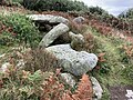
 Ancient Burial Cairn near Dropnose Point - geograph.org.uk - 821798.jpg 640 × 427; 224 KB
-
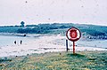
 Boats from the sand-bar - geograph.org.uk - 18118.jpg 640 × 392; 75 KB
-
 Burial Chamber on Kittern Hill - geograph.org.uk - 561683.jpg 640 × 426; 32 KB
-
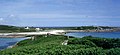
 Central Gugh from The Bar - geograph.org.uk - 1341831.jpg 640 × 278; 66 KB
-
 Cuckolds Carn, Gugh - geograph.org.uk - 910642.jpg 640 × 419; 213 KB
-

-
 From Kittern Hill (1) - geograph.org.uk - 1340039.jpg 640 × 320; 51 KB
-
 Gugh island Scilly.svg 919 × 919; 179 KB
-
 Gugh opposite St Agnes - geograph.org.uk - 875954.jpg 640 × 480; 42 KB
-
 Gugh, lit by the setting sun - geograph.org.uk - 816904.jpg 640 × 427; 113 KB
-
 GughSandbar.JPG 2.304 × 1.728; 2,75 MB
-
 High Tide on The Bar - geograph.org.uk - 570689.jpg 640 × 426; 27 KB
-
 Hoe point looking towards St Agnes - geograph.org.uk - 559909.jpg 640 × 480; 51 KB
-
 Obadiah's Barrow (geograph 3451980).jpg 2.592 × 1.936; 2,98 MB
-
 Obadiah's Barrow - geograph.org.uk - 933202.jpg 640 × 427; 264 KB
-
 Obadiah's Barrow, Gugh (geograph 6284320 by Andrew Abbott).jpg 4.032 × 3.024; 6,58 MB
-
 Old Man of Gugh, Isles of Scilly - geograph.org.uk - 84368.jpg 440 × 640; 133 KB
-
 Porth Conger from The Bar - geograph.org.uk - 1341796.jpg 640 × 278; 74 KB
-
 Porth Conger from The Bar - geograph.org.uk - 817044.jpg 640 × 421; 168 KB
-
 Sand bar to Gugh - geograph.org.uk - 1766260.jpg 640 × 480; 63 KB
-
 Sea Holly on Gugh, St Agnes, Scilly - geograph.org.uk - 1607585.jpg 640 × 480; 205 KB
-
 Sea Thrift - geograph.org.uk - 817056.jpg 427 × 640; 284 KB
-
 Southern Gugh from The Bar - geograph.org.uk - 1341845.jpg 640 × 279; 43 KB
-
 St. Agnes map.png 413 × 358; 11 KB
-

-
 The Bar - geograph.org.uk - 563592.jpg 640 × 426; 26 KB
-
 The Bar at High Tide - geograph.org.uk - 817047.jpg 640 × 427; 196 KB
-

-
 The Gugh - geograph.org.uk - 812626.jpg 640 × 296; 48 KB
-
 The Hoe from Hoe Point - geograph.org.uk - 559902.jpg 480 × 640; 67 KB
-
 The Old Man of Gugh - geograph.org.uk - 816645.jpg 640 × 480; 131 KB
-
 The Way from Gugh - geograph.org.uk - 989819.jpg 640 × 421; 72 KB
-

-
 Waves on Hoe Point - geograph.org.uk - 823298.jpg 640 × 427; 182 KB
-
 Looking across to Gugh from Agnes - geograph.org.uk - 339497.jpg 640 × 480; 95 KB


_-_geograph.org.uk_-_1340039.jpg)


.jpg)

.jpg)


_Bar_linking_Gugh_to_St_Agnes,_from_Gugh_-_geograph.org.uk_-_357390.jpg)


