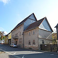
Category:Hauptstraße 21 (Wehrheim)
Jump to navigation
Jump to search
| Object location | | View all coordinates using: OpenStreetMap |
|---|
| Upload media | |||||
| Location |
| ||||
|---|---|---|---|---|---|
| Heritage designation | |||||
 | |||||
This is the category of the Hessian Kulturdenkmal (cultural monument) with the ID 100449 (Wikidata)
|
Media in category "Hauptstraße 21 (Wehrheim)"
The following 3 files are in this category, out of 3 total.
-
 Wehrheim, Hauptstraße 19-23.jpg 4,620 × 4,598; 11.77 MB
-
 Wehrheim, Hauptstraße 21 (1).jpg 4,851 × 5,181; 13.59 MB
-
 Wehrheim, Hauptstraße 21.jpg 6,743 × 4,136; 15.5 MB

.jpg)
