Category:Hauptstraße 38 (Niederhorbach)
Jump to navigation
Jump to search
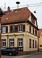
![]() Former school, neo-classical half hipped roof building, first half of the 19th century.
Former school, neo-classical half hipped roof building, first half of the 19th century.
| Object location | | View all coordinates using: OpenStreetMap |
|---|
Media in category "Hauptstraße 38 (Niederhorbach)"
The following 4 files are in this category, out of 4 total.
-
 009 2016 02 19 Kulturdenkmaeler Niederhorbach.jpg 2,694 × 1,856; 3.02 MB
-
 010 2016 02 19 Kulturdenkmaeler Niederhorbach.jpg 1,908 × 2,620; 3.02 MB
-
 011 2016 02 19 Kulturdenkmaeler Niederhorbach.jpg 1,805 × 2,768; 3.04 MB
-
 Niederhorbach Hauptstr 38.jpg 2,304 × 3,072; 947 KB


