Category:Hauptstraße 39 (Kirchberg (Hunsrück))
Jump to navigation
Jump to search
| Object location | | View all coordinates using: OpenStreetMap |
|---|
Media in category "Hauptstraße 39 (Kirchberg (Hunsrück))"
The following 4 files are in this category, out of 4 total.
-
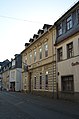 Kirchberg (Hunsrück), Hauptstraße 39 (1).jpg 3,264 × 4,928; 4.73 MB
-
 Kirchberg (Hunsrück), Hauptstraße 39 (2).jpg 3,264 × 4,900; 6.11 MB
-
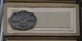 Kirchberg (Hunsrück), Hauptstraße 39, Detail.jpg 2,956 × 1,496; 1.9 MB
-
 Kirchberg (Hunsrück), Hauptstraße 39.jpg 3,256 × 4,873; 6.48 MB
,_Hauptstra%C3%9Fe_39_(1).jpg)
,_Hauptstra%C3%9Fe_39_(2).jpg)
,_Hauptstra%C3%9Fe_39,_Detail.jpg)
,_Hauptstra%C3%9Fe_39.jpg)