Category:Hauptstraße 7 (Höchstadt an der Aisch)
Jump to navigation
Jump to search
| Object location | | View all coordinates using: OpenStreetMap |
|---|
building in Höchstadt an der Aisch, Middle Franconia, Germany  | |||||
| Upload media | |||||
| Instance of | |||||
|---|---|---|---|---|---|
| Location | Höchstadt an der Aisch, Erlangen-Höchstadt, Middle Franconia, Bavaria, Germany | ||||
| Street address |
| ||||
| Heritage designation | |||||
 | |||||
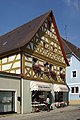
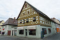
This is the category of the Bavarian Baudenkmal (cultural heritage monument) with the ID D-5-72-135-28 (Wikidata)
|
Deutsch: Höchstadt an der Aisch - Hauptstraße 7 - Bürgerhaus. Zweigeschossiger giebelständiger Satteldachbau mit Zierfachwerkobergeschoss, 1. Hälfte 18. Jahrhundert.
Media in category "Hauptstraße 7 (Höchstadt an der Aisch)"
The following 3 files are in this category, out of 3 total.
-
 Höchstadt an der Aisch - Hauptstraße 7 - 01.jpg 3,357 × 4,196; 5.86 MB
-
 Höchstadt an der Aisch BW 2011-07-27 17-40-01.JPG 2,248 × 3,370; 3.59 MB
-
 Höchstadt an der Aisch, Hauptstraße 7, 001.jpg 4,928 × 3,264; 7.76 MB

