Category:Hauptstraße 76 (Niederhorbach)
Jump to navigation
Jump to search
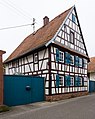
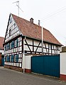
![]() Hauptstraße 76, farmstead.
Hauptstraße 76, farmstead.
- Half-timbered house, late 18th or early 19th century.
| Object location | | View all coordinates using: OpenStreetMap |
|---|
Media in category "Hauptstraße 76 (Niederhorbach)"
The following 5 files are in this category, out of 5 total.
-
 023 2016 02 19 Kulturdenkmaeler Niederhorbach.jpg 1,995 × 2,506; 3 MB
-
 024 2016 02 19 Kulturdenkmaeler Niederhorbach.jpg 1,937 × 2,579; 2.41 MB
-
 025 2016 02 19 Kulturdenkmaeler Niederhorbach.jpg 1,969 × 2,537; 3.16 MB
-
 026 2016 02 19 Kulturdenkmaeler Niederhorbach.jpg 2,661 × 1,878; 3.27 MB
-
 Niederhorbach Hauptstr 76.jpg 2,304 × 3,072; 537 KB


