Category:Hervormde kerk, Ammerzoden
Jump to navigation
Jump to search
| Object location | | View all coordinates using: OpenStreetMap |
|---|
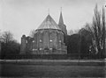
church in Ammerzoden, the Netherlands  | |||||
| Upload media | |||||
| Instance of | |||||
|---|---|---|---|---|---|
| Location | Ammerzoden, Gelderland, Netherlands | ||||
| Street address |
| ||||
| Located on street |
| ||||
| Has part(s) | |||||
| Heritage designation |
| ||||
 | |||||
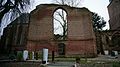
Nederlands: Ruïnekerk, Ammerzoden - anno 14e eeuw
Kerk:
|
This is a category about rijksmonument number 8105
|
Toren:
|
This is a category about rijksmonument number 8106
|
| Address |
|
Media in category "Hervormde kerk, Ammerzoden"
The following 62 files are in this category, out of 62 total.
-
 17ammerzodenkerk.png 1,600 × 1,200; 4.21 MB
-
 5324 Ammerzoden, Netherlands - panoramio (10).jpg 2,048 × 1,148; 707 KB
-
 5324 Ammerzoden, Netherlands - panoramio (12).jpg 2,048 × 1,148; 822 KB
-
 5324 Ammerzoden, Netherlands - panoramio (14).jpg 2,048 × 1,148; 579 KB
-
 5324 Ammerzoden, Netherlands - panoramio (16).jpg 2,048 × 1,148; 750 KB
-
 5324 Ammerzoden, Netherlands - panoramio (19).jpg 2,048 × 1,148; 673 KB
-
 5324 Ammerzoden, Netherlands - panoramio (20).jpg 1,148 × 2,048; 599 KB
-
 5324 Ammerzoden, Netherlands - panoramio (21).jpg 2,048 × 1,148; 659 KB
-
 5324 Ammerzoden, Netherlands - panoramio (22).jpg 2,048 × 1,148; 707 KB
-
 5324 Ammerzoden, Netherlands - panoramio (23).jpg 1,148 × 2,048; 496 KB
-
 5324 Ammerzoden, Netherlands - panoramio (8).jpg 1,148 × 2,048; 670 KB
-
 Ammerzoden - Toren van de Hervormde ruinekerk (2).jpg 2,000 × 3,000; 3.71 MB
-
 Ammerzoden - Toren van de Hervormde ruinekerk.jpg 2,000 × 3,000; 5.49 MB
-
 Ammerzoden Castle Church.jpg 2,048 × 1,536; 657 KB
-
 Castle Church Ruins Ammerzoden Village in the Netherlands.jpg 2,736 × 3,648; 2.33 MB
-
 CastleAmmersoyen-Church.jpg 2,048 × 1,536; 707 KB
-
 De kerktoren in de steigers - Ammerzoden - 20534939 - RCE.jpg 897 × 1,200; 174 KB
-

-
 De verwoeste Hervormde kerk vanuit het zuiden - Ammerzoden - 20534933 - RCE.jpg 1,200 × 859; 213 KB
-
 De verwoeste Hervormde kerk- schip en toren - Ammerzoden - 20534934 - RCE.jpg 860 × 1,200; 169 KB
-
 De verwoeste toren van de Hervormde kerk - Ammerzoden - 20534935 - RCE.jpg 914 × 1,200; 197 KB
-
 Detail hervormde kerk- ruïne gewelfaanzet - Ammerzoden - 20318899 - RCE.jpg 1,200 × 914; 200 KB
-
 Detail toren - Ammerzoden - 20010621 - RCE.jpg 875 × 1,200; 252 KB
-
 Een dorpskerk, RP-T-1882-A-167.jpg 6,588 × 4,160; 5.3 MB
-
 Exterieur KOOR, ZUIDOOST GEVEL - Ammerzoden - 20279595 - RCE.jpg 1,200 × 956; 401 KB
-
 Exterieur NOORDGEVEL - Ammerzoden - 20279593 - RCE.jpg 1,200 × 957; 387 KB
-

-
 Exterieur OVERZICHT OOSTGEVEL (KOOR) - Ammerzoden - 20279594 - RCE.jpg 1,200 × 947; 363 KB
-
 Exterieur OVERZICHT ZUIDGEVEL, ZUIDERTRANSEPT - Ammerzoden - 20279596 - RCE.jpg 1,200 × 956; 407 KB
-
 Exterieur ZUIDGEVEL - Ammerzoden - 20279597 - RCE.jpg 954 × 1,200; 407 KB
-
 Gedeelte noord-gevel met toren - Ammerzoden - 20010628 - RCE.jpg 1,200 × 1,197; 507 KB
-
 Gedeelte noord-gevel, ruïne - Ammerzoden - 20010626 - RCE.jpg 1,200 × 1,197; 487 KB
-
 Gedeelte noord-gevel, ruïne - Ammerzoden - 20010627 - RCE.jpg 1,191 × 1,200; 491 KB
-

-
 Gezicht op de kerk vanuit het zuidoosten - Ammerzoden - 20010617 - RCE.jpg 1,200 × 883; 309 KB
-
 INTERIEUR, KOOR, OVERZICHT NAAR HET OOSTEN - Ammerzoden - 20279603 - RCE.jpg 954 × 1,200; 197 KB
-
 INTERIEUR, KOOR, OVERZICHT NAAR HET WESTEN - Ammerzoden - 20279602 - RCE.jpg 957 × 1,200; 202 KB
-
 INTERIEUR, OOSTGEVEL - Ammerzoden - 20279601 - RCE.jpg 951 × 1,200; 413 KB
-
 INTERIEUR, OVERZICHT NAAR HET NOORDWESTEN - Ammerzoden - 20279598 - RCE.jpg 1,200 × 951; 447 KB
-
 INTERIEUR, OVERZICHT NAAR HET ZUIDOOSTEN - Ammerzoden - 20279600 - RCE.jpg 1,200 × 957; 415 KB
-
 INTERIEUR, OVERZICHT NAAR HET ZUIDWESTEN - Ammerzoden - 20279599 - RCE.jpg 1,200 × 947; 435 KB
-
 Kerktoren - Ammerzoden - 20010623 - RCE.jpg 894 × 1,200; 255 KB
-
 Koor en ruïnekerk vanuit het zuidoosten - Ammerzoden - 20010615 - RCE.jpg 1,200 × 871; 272 KB
-
 Nhkerkammerzoden.jpg 2,576 × 1,952; 1.26 MB
-
 Noord-gevel noord-transept, ruïne - Ammerzoden - 20010625 - RCE.jpg 1,195 × 1,200; 504 KB
-
 Noordgevel koor - Ammerzoden - 20010624 - RCE.jpg 1,197 × 1,200; 537 KB
-
 Onderste deel van de kerktoren in de steigers - Ammerzoden - 20534940 - RCE.jpg 894 × 1,200; 169 KB
-
 Oorlogsschade aan de Hervormde kerk - Ammerzoden - 20534936 - RCE.jpg 909 × 1,200; 211 KB
-

-

-
 Oude kerk Ammerzoden.jpg 690 × 336; 54 KB
-
 Overzicht ruïne van de kerk met toren - Ammerzoden - 20010622 - RCE.jpg 1,200 × 894; 208 KB
-
 Ruins, Castle Church Ammerzoden.jpg 1,536 × 2,048; 665 KB
-
 Ruïne deel zuidgevel hervormde kerk met poort - Ammerzoden - 20318898 - RCE.jpg 918 × 1,200; 219 KB
-

-
 Ruïnekerk, Ammerzoden.jpg 300 × 400; 138 KB
-
 Westzijde van het koor - Ammerzoden - 20010620 - RCE.jpg 875 × 1,200; 326 KB
-
 Zicht in het schip naar het westen - Ammerzoden - 20010618 - RCE.jpg 880 × 1,200; 225 KB
-
 Zicht op de Kerk vanuit het zuiden - Ammerzoden - 20010616 - RCE.jpg 864 × 1,200; 248 KB
-
 Zicht op deel ruïne van schip hervormde kerk - Ammerzoden - 20319918 - RCE.jpg 958 × 1,200; 236 KB
-
 Zuid-oost gevel koor - Ammerzoden - 20010629 - RCE.jpg 1,190 × 1,200; 521 KB
-
 Zuid-oost gevel, zuidtransept - Ammerzoden - 20010630 - RCE.jpg 1,190 × 1,200; 528 KB
.jpg)
.jpg)
.jpg)
.jpg)
.jpg)
.jpg)
.jpg)
.jpg)
.jpg)
.jpg)
.jpg)


_-_Ammerzoden_-_20279594_-_RCE.jpg)


_-_Ammerzoden_-_20010614_-_RCE.jpg)


