Category:Hervormdekapel Deventer
Jump to navigation
Jump to search
| Object location | | View all coordinates using: OpenStreetMap |
|---|
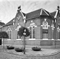
church building in Deventer, Netherlands  | |||||
| Upload media | |||||
| Instance of | |||||
|---|---|---|---|---|---|
| Location | Deventer, Overijssel, Netherlands | ||||
| Street address |
| ||||
| Located on street | |||||
| Architect | |||||
| Heritage designation |
| ||||
| Inception |
| ||||
| Religion or worldview |
| ||||
 | |||||
|
This is a category about rijksmonument number 510741
|
| Address |
|
Media in category "Hervormdekapel Deventer"
The following 2 files are in this category, out of 2 total.
-
 Graaf van Burenstraat 12 Deventer.jpg 640 × 428; 40 KB
-
 Overzicht zuidoostgevel - Deventer - 20350841 - RCE.jpg 1,200 × 1,186; 312 KB
