Category:Highland County, Virginia
Перейти до навігації
Перейти до пошуку
Counties of Virginia: Accomack · Albemarle · Alleghany · Amelia · Amherst · Appomattox · Arlington · Augusta · Bath · Bedford · Bland · Botetourt · Brunswick · Buchanan · Buckingham · Campbell · Caroline · Carroll · Charles City · Charlotte · Chesterfield · Clarke · Craig · Culpeper · Cumberland · Dickenson · Dinwiddie · Essex · Fairfax · Fauquier · Floyd · Fluvanna · Franklin · Frederick · Giles · Gloucester · Goochland · Grayson · Greene · Greensville · Halifax · Hanover · Henrico · Henry · Highland · Isle of Wight · James City · King and Queen · King George · King William · Lancaster · Lee · Loudoun · Louisa · Lunenburg · Madison · Mathews · Mecklenburg · Middlesex · Montgomery · Nelson · New Kent · Northampton · Northumberland · Nottoway · Orange · Page · Patrick · Pittsylvania · Powhatan · Prince Edward · Prince George · Prince William · Pulaski · Rappahannock · Richmond · Roanoke · Rockbridge · Rockingham · Russell · Scott · Shenandoah · Smyth · Southampton · Spotsylvania · Stafford · Surry · Sussex · Tazewell · Warren · Washington · Westmoreland · Wise · Wythe · York
county in Virginia, United States   | |||||
| Завантажити медіафайл | |||||
| Є одним із | |||||
|---|---|---|---|---|---|
| Названо на честь |
| ||||
| Місце розташування | Вірджинія, США | ||||
| Столиця | |||||
| Дата створення / заснування |
| ||||
| Кількість населення |
| ||||
| Площа |
| ||||
| Не плутати з | |||||
| офіційний сайт | |||||
 | |||||
Підкатегорії
Показано 12 підкатегорій із 12.
Файли в категорії «Highland County, Virginia»
Показано 48 файлів цієї категорії (із 48).
-

-

-

-

-

-

-

-

-

-

-

-

-

-

-

-
-

-

-

-

-

-

-

-

-

-

-
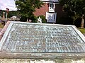 Battle of McDowell plaque.jpg 797 × 591; 122 КБ
-
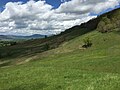
 Blue Grass Valley 1.jpg 4896 × 3264; 8,58 МБ
-
 Blue Grass Valley 2.jpg 4896 × 2914; 9,86 МБ
-
 Blue Grass Valley 3.jpg 4896 × 3264; 10,52 МБ
-
 Blue Grass Valley 4.jpg 4896 × 3264; 9,83 МБ
-
 Blue Grass Valley 5.jpg 4896 × 3264; 9,39 МБ
-
 Blue Grass Valley 6.jpg 4896 × 3264; 8,65 МБ
-
 Blue Grass, VA, USA - panoramio.jpg 9695 × 5179; 9,48 МБ
-
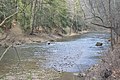 Bullpasture River above Williamsville.jpg 6016 × 4000; 6,49 МБ
-
 Clover Creek, Virginia National Map.jpg 1454 × 1136; 970 КБ
-
 Cows Blue Grass, Virginia.jpg 3456 × 2304; 4,25 МБ
-
 Devils Backbone (Highland County, Virginia).jpg 1600 × 1067; 512 КБ
-
 Doe Hill, Virginia National Map.jpg 998 × 972; 700 КБ
-
 Hardscrabble VA National Map.JPG 657 × 624; 395 КБ
-
 Highland County Area 422 Square Miles historical marker.jpg 6016 × 4000; 7,07 МБ
-
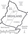 Highland County Virginia Census Map.jpg 1173 × 1407; 406 КБ
-
 HighlandCounty.wmg.jpg 1200 × 691; 104 КБ
-
 Laurel Fork, Highland County, Virginia USGS.jpg 1364 × 706; 1,21 МБ
-
 McDowell cemetery plaque.JPG 1017 × 605; 192 КБ
-
 New Hampden, Virginia National Map.jpg 942 × 888; 623 КБ
-
 Possum Trot, Virginia National Map.jpg 1390 × 1086; 1,1 МБ
-
 USA Highland County, Virginia age pyramid.svg 520 × 600; 7 КБ
_on_the_northwestern_slopes_of_Monterey_Mountain_in_Highland_County,_Virginia.jpg)
_on_the_northwestern_slopes_of_Monterey_Mountain_in_Highland_County,_Virginia.jpg)
_on_the_northwestern_slopes_of_Monterey_Mountain_in_Highland_County,_Virginia.jpg)
_on_the_northwestern_slopes_of_Monterey_Mountain_in_Highland_County,_Virginia.jpg)
_in_northwestern_Highland_County,_Virginia.jpg)
_in_northwestern_Highland_County,_Virginia.jpg)
_in_northwestern_Highland_County,_Virginia.jpg)
_in_northwestern_Highland_County,_Virginia.jpg)
_in_northwestern_Highland_County,_Virginia.jpg)
_in_northwestern_Highland_County,_Virginia.jpg)
_on_the_northwestern_slopes_of_Monterey_Mountain_in_Highland_County,_Virginia.jpg)
_on_the_northwestern_slopes_of_Monterey_Mountain_in_Highland_County,_Virginia.jpg)
_on_the_northwestern_slopes_of_Monterey_Mountain_in_Highland_County,_Virginia.jpg)
_on_the_northwestern_slopes_of_Monterey_Mountain_in_Highland_County,_Virginia.jpg)
_on_the_northwestern_slopes_of_Monterey_Mountain_in_Highland_County,_Virginia.jpg)
_in_Highland_County,_Virginia.jpg)
_in_Highland_County,_Virginia.jpg)
_in_Highland_County,_Virginia.jpg)
_in_Highland_County,_Virginia.jpg)
_in_Highland_County,_Virginia.jpg)
_in_Highland_County,_Virginia.jpg)
_in_Highland_County,_Virginia.jpg)
_in_Highland_County,_Virginia.jpg)


.jpg)


_on_the_northwestern_slopes_of_Monterey_Mountain_in_Highland_County,_Virginia.jpg)
_in_northwestern_Highland_County,_Virginia.jpg)
_in_Highland_County,_Virginia.jpg)