Category:Hild 3, Moergestel
Jump to navigation
Jump to search
| Object location | | View all coordinates using: OpenStreetMap |
|---|
farmhouse in Oisterwijk, Netherlands  | |||||
| Upload media | |||||
| Instance of | |||||
|---|---|---|---|---|---|
| Location | Moergestel, North Brabant, Netherlands | ||||
| Street address |
| ||||
| Located on street |
| ||||
| Heritage designation |
| ||||
 | |||||
|
This is a category about rijksmonument number 519966
|
| Address |
|
Media in category "Hild 3, Moergestel"
The following 27 files are in this category, out of 27 total.
-
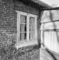 Exterieur achtergevel, detail van raamkozijn - Moergestel - 20327231 - RCE.jpg 1,188 × 1,200; 311 KB
-
 Exterieur gedeelte zijgevel - Moergestel - 20327229 - RCE.jpg 1,179 × 1,200; 478 KB
-
 Exterieur overzicht - Moergestel - 20327220 - RCE.jpg 1,181 × 1,200; 466 KB
-
 Exterieur overzicht - Moergestel - 20327222 - RCE.jpg 1,181 × 1,200; 505 KB
-
 Exterieur overzicht achtergevel - Moergestel - 20327227 - RCE.jpg 1,179 × 1,200; 525 KB
-
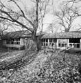
 Exterieur overzicht erf - Moergestel - 20327238 - RCE.jpg 1,188 × 1,200; 527 KB
-
 Exterieur overzicht erf - Moergestel - 20327239 - RCE.jpg 1,183 × 1,200; 496 KB
-
 Exterieur overzicht erf - Moergestel - 20327240 - RCE.jpg 1,181 × 1,200; 482 KB
-
 Exterieur overzicht erf - Moergestel - 20327241 - RCE.jpg 1,188 × 1,200; 558 KB
-
 Exterieur overzicht linker zijgevel en achtergevel - Moergestel - 20327228 - RCE.jpg 1,188 × 1,200; 503 KB
-
 Exterieur overzicht rechter zijgevel - Moergestel - 20327223 - RCE.jpg 1,174 × 1,200; 492 KB
-
 Exterieur overzicht voorgevel met gedeelte schuur - Moergestel - 20327225 - RCE.jpg 1,195 × 1,200; 498 KB
-
 Exterieur restant bakhuis, overzicht achterkant - Moergestel - 20327237 - RCE.jpg 1,188 × 1,200; 542 KB
-

-

-
 Exterieur schade aan voorgevel door boomwortels - Moergestel - 20327232 - RCE.jpg 1,190 × 1,200; 484 KB
-
 Exterieur schade aan voorgevel door boomwortels - Moergestel - 20327233 - RCE.jpg 1,188 × 1,200; 392 KB
-
 Exterieur voordeur, slechte deurpost - Moergestel - 20327230 - RCE.jpg 1,192 × 1,200; 369 KB
-
 Interieur kelder - Moergestel - 20327245 - RCE.jpg 1,190 × 1,200; 254 KB
-
 Interieur opkamer met trap - Moergestel - 20327243 - RCE.jpg 1,185 × 1,200; 237 KB
-

-

-
 Interieur schuur, korbeel - Moergestel - 20327250 - RCE.jpg 1,197 × 1,200; 343 KB
-
 Interieur schuur, oplegging trekbalk aan straatzijde - Moergestel - 20327251 - RCE.jpg 1,178 × 1,200; 303 KB
-
 Interieur schuur, overzicht binnenzijde deuren - Moergestel - 20327249 - RCE.jpg 1,188 × 1,200; 388 KB
-

-
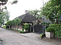 Moergestel Hild 3.JPG 4,320 × 3,240; 2.11 MB


